Dominica- part 2

The Salty Dawg Rendezvous started the evening of February 13th with a welcome dinner at the PAYS pavilion. Despite the 2-3 weeks’ worth of uncooperative sea conditions, about 21 boats made it to the rendezvous. They don’t call them “salty” dawgs for nothing. We are so glad that we made the effort to get to this rendezvous. We had an amazing time and made many new friends. 

PAYS (Portsmouth Association of Yacht Security) coordinated with the Salty Dawg organization to host this event, but PAYS developed the itinerary. Each day offered 1-3 tour options led by PAYS guides, and the evenings found us gathering at the PAYS pavilion or Cabrit Cruise Ship pavilion for dinner, music and dancing. Most of us who were in Dominica for the first time opted to join every tour, so Dave and I were quite busy the entire week. We did so much over six days that I couldn’t possibly retain everything I learned about the island and its culture, but I can give you an overview.

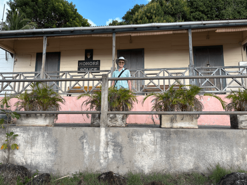
I want to tell you a little about PAYS [link], first. Dominica was not a very safe place for cruisers to visit in the 90s and early 2000s. The government wasn’t particularly interested in doing anything about this, so a small group of local tour guides took things into their own hands and established PAYS, with the overarching goal of ensuring cruisers felt welcomed and safe. They operate at Prince Rupert Bay, outside the town of Portsmouth, on the NW side of Dominica. All members are trained and registered tour guides, and many also own other businesses like a taxi service or restaurant. Over time, they have built what we saw while we were there- an office and attached pavilion where they host BBQs every Wednesday and Sunday from December-May, a good dinghy dock, showers & bathrooms (not the greatest), a mooring field, and they take it in turns to patrol the mixed mooring field/anchorage at night. 

This is a well-run business. You always know who the PAYS members are because their boats are clearly marked and they proudly display their tour guide credentials. They are incredibly helpful, very pleasant, and eager to share their knowledge and love of their island. Yes, they do this to bring in money, but they are not pushy, at least we didn’t find them to be so. Someone might stop by if they see you aboard and ask if you need a ride, water, fuel, tour, etc., but if the answer is “no, thank you,” they move on. We found their prices to be reasonable. Moorings are $12 US per night, with a slightly better deal if you pay for a whole week. Tours that are 6-8 hours run about $60 US for the driver/guide, although there are often other fees, but those are paid directly to whoever established the fee, like the government or a landowner; they were in the $5-$10 US range. We spent more than anticipated, but it was money well spent, and we couldn’t have done anything close for the same price tag in the US or any other developed nation.

Back to the fun stuff- what we DID.

Day 1- Welcome dinner

The welcome dinner occurred during the weekly Saturday BBQ, so there were more than just Salty Dawgs attending. We were welcomed by PAYS and an overview of the week was given by the Dawgs volunteer coordinator, Mary. Dinner was BBQ chicken, rice and salad, a recurring theme to our meals, with endless rum punch. I guess the punch fueled the dancing. We only stayed for a little bit of the dancing because the next day was an early, all-day tour and we wanted to be rested.   

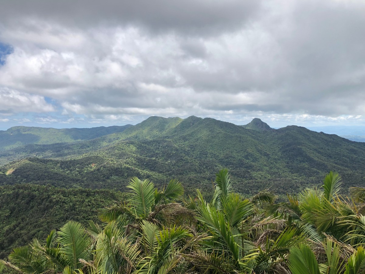
Day 2- Northern Treasures Tour

Guess which part of the island this tour covered 😉. Our driver/guide was Marlon, a fairly new guide with a good knowledge of local plants that he was also eager to expand. As we drove to our first stop, Marlon gave us a little history; he’s still learning that, too. Our first stop was for a hike to Chaudière Pool. Since this crossed someone’s private land, we paid $10 US each for that, but it also got us an additional guide called Anit, who knows the area and flora very well. She and Marlon pointed out various plants along the trail and told us about their uses, both as food and medicine, we even sampled some. Marlon learned a lot from Anit along the way. 

The pool was lovely and both Dave and I changed into swimsuits to bathe in it, and I mean bathe. Anit had collected soap leaf en route and showed us to crush it up, mix it with some water and rub it over our skin. Darned if it didn’t create a little green lather. It felt refreshing, too, though that may have just been the cool water 😁. On the way back, Anit brought us down off the road to her farm and gave us some of the very sweet, tiny bananas I have forgotten the name of, as well as some sugar cane. She was lovely. 

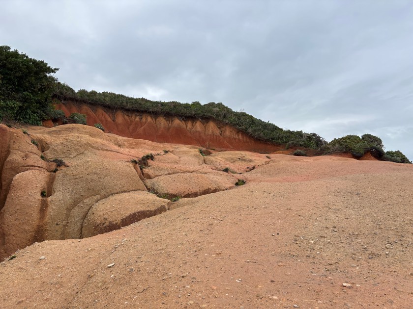
After Chaudière Pool, we had lunch in Calabishe. It was delicious and very big! We then went to the Sea Cliff Gin Distillery for a free tour and tasting (yes, free for anyone, so far). We then made a quick stop at Red Rocks ($2 US per person), thus named because of the iron oxide in the volcanic rocks that form them. The rock is very soft, which surprised me. Our final stop for the day was at the Pointe Baptiste Chocolate Factory ($20 EC per group). It’s a small operation that started in the couple’s kitchen and expanded to a lower level and behind their house. They produce about 2 tons of chocolate a year, all sold locally. It is dark chocolate flavored with local plant products. Even better, we got to taste as many of the 20 different flavors as we wanted. We left with only two bars, but we bought two more when we returned another day with our visiting family. Yum! 

Dinner that night was a fundraiser for the local cancer society and was served at the Cabrits Cruise Ship dock. It was well-catered and consisted of chicken and fish options, rice, salad, and a couple of other starchy sides (local root vegetables). Too tired for dancing that night! We did not stay long after finishing the meal.

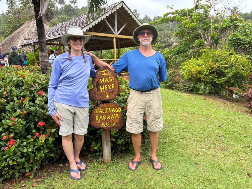
Day 3- Kalinago Territory Tour

This day started with a 2-hour drive across the island to the east side. Our driver/guide was “Uncle Sam.” As we crossed the island he told us a bunch of its history, described the little towns and villages we passed through, pointed out various plants, and told us about the international airport being built by the Chinese. Once we arrived in the Kalinago village, a local guide took over. The information I provide below is partly from the tour, but also from a Dominican history website [link].

The Kalinago, formerly referred to as the Caribs, are the original inhabitants of the island, believed to have arrived from South America. Their history on the island goes back to about 1000 A.D. Today’s Kalinago are the last remaining descendants, most now of mixed heritage. In the not so distant past, they kept themselves to themselves, separate from the rest of the island’s society. As our guide told us this day, however, that is changing and they are integrating more, some even choosing not to live in the territory. 

Theirs is a familiar story, their simple life in harmony with nature was disrupted by the arrival of Christopher Columbus and later, European settlers, with whom they fought. They eventually escaped to the less hospitable eastern side of the island where, in 1763, the British gave them their first, dedicated 232 acres of land. In 1903, the territory was expanded to 3700 acres spanning about 8 miles of the east coast. The original name of Dominica, Waitukubuli, was from their language. It means “tall is her body,” referencing her volcanic mountains.

There are eight villages in the Kalinago territory. We visited their model village, Kalinago Barana Aute. I read that they offer a variety of other tours. Perhaps we’ll do one on our next visit. They are self-governing, with a democratically elected chief and council, but they work in cooperation with the Dominican government and have a representative there. Like most indigenous cultures in the world, they struggle to maintain their culture and traditions, striving to pass them on to younger generations, while also trying to integrate to some extent with modern society. In the case of the Kalinago, they have started to prioritize a rounded education as well as good health care. While they continue to value and practice organic agricultur, and continue their weaving and other crafts, which bring income, they are also looking toward ecotourism and other opportunities. 

As he spoke, our guide led us along a well-groomed trail through this model village with some stunning views. We ended with a simple lunch and the opportunity to peruse and purchase some of their crafts. If I had room on the boat for one of their gorgeous baskets, or thought I could get it back to the US safely, I would have purchased one. Instead, I bought a lovely necklace and matching pair of earrings made of white and red seeds.

We returned to the west side of the island, and that evening enjoyed a dinner of “Caribbean Flavors.” This included salt cod, roasted bananas and breadfruit, green papaya, and cucumber and cabbage salad. For “dessert,” there was cocoa tea, a wonderfully flavorful combination of local cocoa, cinnamon, nutmeg and coconut milk. Delicious! After two long, tiring, exciting days in a row, we did not stay for the music and dancing.

I’m going to stop here for now, since you’ve had to read so much already. I’ll finish up describing the rendezvous and tours in Dominica- part 3, which I’ll post in a few days. 

Until then, stay safe and take care of each other!

Dominica- part 1

Sorry for the delay, folks. I’m not feeling the blog this year. It’s probably because I’m enjoying myself and haven’t really felt like making time to write. At any rate, I’ll catch you up a bit now.

We arrived in Dominica on February 5th, eight days before the start of the Salty Dawg Rendezvous. We landed in Prince Rupert Bay, at the town of Portsmouth. After clearing into the country with customs and immigration, we had a late lunch ashore, purchased a local Digicel SIM card in town, then spent the rest of the day relaxing on Lady.

Our time in Dominica, pre-rendezvous, wasn’t particularly interesting. We were just living normal boat life, just in another beautiful and warm place. We tended to boat tasks like minor repairs, cleaning, changing beds, doing laundry and making English muffins. We acquired some local currency, Eastern Caribbean Dollars, which required ultimately going into the bank after two ATMs refused our debit card. We explored the town of Portsmouth. We took a taxi into Roseau, the capital of Dominica on the southwest side of the island, to get one of our propane tanks filled and to pick up our new Garmin multifunction display. (I described our issue in my post on 1/15; it’s “Bump #4.”) We also met and hung out with a couple of Salty Dawgs who, like us, arrived in Dominica early.

Our explorations of the area included food, of course. We quickly discovered that one can get fresh produce any day of the week on the block near the fishing/town dock. On Saturday, however, they have an even bigger fresh market with MORE produce. Oh, the produce! This island grows quite a variety of produce. I felt like a kid in a candy store, only with healthier options. I even tried a new fruit called sapodilla, or sapotille. We had a particularly tasty Saturday lunch (after the fresh market) of broth and soup. My “broth” contained two small marlin fish steaks, a variety of “ground provisions” (root vegetables like sweet potato), banana, and smoked chicken wing. I don’t know what seasonings were used, but between those and the smoked chicken it was so flavorful! Dave also enjoyed his “soup,” which contained smoked chicken wing, smoked red meat of some kind (probably pork), some sort of root vegetables, in a savory stew-type broth. We were quite pleased.

We spent that morning of the 13th walking around Fort Shirley, located in the Cabrits (twin hills separating Prince Rupert Bay from Douglas Bay to the north). We even hiked across to a viewpoint of Douglas Bay. That evening, the rendezvous kicked off with a BBQ welcome dinner in the PAYS pavilion. I’ll tell you all about PAYS and the rendezvous next time. 

Until then, stay safe and take care of each other!

Six days in Guadeloupe

As you know, if you’ve been following us this season, we left St. Kitt’s & Nevis and eventually made it to Guadeloupe on January 30th(The details, if you missed them, are in my posts on February 1st and 5th). We landed in Deshaies (pronounced Day-ay) on the northwest corner of Basse Terre. Guadeloupe comprises two main islands that form a sort of butterfly shape, with Basse Terre to the west separated from Grand Terre to the east by a narrow mangrove channel, plus, to the south, there is Marie Galante, and west of that a group of smaller islands called Les Saintes.

Fans of the British mystery, Death in Paradise, will know that it is filmed in various parts of Guadeloupe. The Honoré Police Department is in Deshaies, and yes, we stopped to see it, from the outside. We weren’t willing to pay $20 US each to stand in the tiny room for ten minutes and look at the police desks and cell. We heard someone say there’s a tour that takes you to several of the filming sites, for about $100 US per person. No thank you.

Death in Paradise aside, we enjoyed the two days and three nights we spent on a mooring in the harbor of Deshaies. For my birthday on the 31st, we toured the Jardin Botanique de Deshaies (the Deshaies Botanical Gardens). It was totally worth the $17.50 € ($18.54 US)  per person! They were gorgeous, and they went on and on! There were built in water features, including a couple of ponds, a river and a waterfall with a restaurant perched on top. There was also a walk-in lorikeet aviary and another area with various Macaws, most of whom were napping in their little huts when we arrived. We decided lunch would be our main meal of the day for my birthday, so we treated ourselves to a delicious lunch, including dessert, at the restaurant I mentioned atop the waterfall. The views from the deck were spectacular! We had taken the free shuttle up hill to the garden, but after that big lunch decided we should walk the 1+ miles back to the dinghy dock. We opted for a mini charcuterie for dinner, as well as music in our hammocks before bed. It was a wonderful way to spend my birthday!

The next day, February 1st, after croissants ashore for breakfast and getting some gasoline for dinghy, we prepared a picnic lunch (sandwiches on baguette, of course) and went for a hike. Actually, it was more of a rock scramble. We “hiked” up the bed of the Deshaies River, something one can only do when the water level is low, as it was this day. It was beautiful, winding its way through the tropical forest. Occasionally we had to bushwhack a bit ashore to get around parts of the river without good scrambling rocks. Dave cooled himself off in one of the pools in the river along the way. We were aiming for where the river intersected the road that would lead us back to town. About 2 hours into the hike, knowing we had to be pretty close to that road, but not quite sure how close, it started to rain. That made the rocks slippery. Ack! We waited until the downpour stopped, then continued our scramble more slowly for another 15 minutes or so until we came to a spillway across the river with a house on the south bank. Dave scrambled up the north bank toward where he thought it looked like there was a road and confirmed that there was, so I followed. The cruising guide said it was about a 15 minute walk back to town. It was more like 45 minutes and quite steep going down, but we got back uneventfully. It was just lunch time when we got back to town, so we sat on a bench in a little park and ate our yummy sandwiches. Then we visited the local rum store, bought a bottle, then I got ice cream before we returned to Lady. We were a bit sore, but it had been a lovely day.

Deshaies River hike- 5

On Sunday we decided that we wanted a change of scenery before we took the upcoming weather window to Dominica. We moved down to Plage de la Malendure (Misery Beach; sounds nicer in French). We were still sore from the previous day’s hike, so we made water and did laundry, but otherwise rested. The next day, however, we popped across to Pigeon Island in our dinghy and snorkeled around in this part of Jacques Cousteau Marine Park. The reefs are struggling these days, but there was some coral and sponges and LOTS of fish, many schools of them. It was an enjoyable snorkel. After lunch back aboard Lady, we dinghied into the beach to walk about a bit. It’s a vacationers’ spot with lots of dive/snorkel shops along the beach, as well as food shacks/restaurants and souvenir shops. 

The following day we moved down to Marina Sud Ancrage (South Anchorage Marina) on the southwest end of Basse Terre. We filled up with very expensive diesel, cleared out of the country, had lunch at the marina, and then dinghied about a mile back north to the main town of Basse Terre to get a SIM card and some parts Dave needed. I know, it sounds weird to get a SIM the day before leaving the country, but we’re pretty sure that when we return to Guadeloupe in late February, we’ll head to Les Saintes, and we knew we would not be able to purchase a SIM there. The plan we ended up buying is good for two months, so we’ll be all set when we return. It wasn’t easy getting the SIM and plan, since the employees at Orange (the cellular provider) speak little English and I speak little French. Between translators on our phones, our smattering of each other’s languages, and a lot of good-natured patience, I had what I needed, plus an extra 10 GB of data because there was a glitch and I had to wait quite a bit while the lovely woman assisting me called Orange to verify that the package I’d purchased was in fact activated. That was nice of them. We were back on Lady by 4:30 pm, had leftovers for dinner, and watched the Bruins win before retiring to bed.

We landed in Dominica before noon on February 5th and that’s where we are now. We will be here at least through the 23rd (ish). The Salty Dawg rendezvous runs from the 13th to the 20th, and we have family arriving here immediately after that. But I’m going to stop here and fill you in about Dominica later. 

Until then, stay safe and take care of each other!

Back in St. Kitt’s & Nevis

Let’s catch up on things other than traveling between islands…

We finally launched on January 17th. Dave was satisfied with the copper coat work that had been done. (He has since checked the hulls, the day we arrived in Dominica, and said there is no growth on them. Yay!) It also turned out that the hourly rate we were quoted for the work was in ECD (Eastern Caribbean Dollars), so it was only $25 USD/hour and therefore not as expensive a job as we’d thought. We tied up to one of their rickety docks on the 17th and did the bulk of our provisioning that afternoon. We spent the night listening to our lines creak loudly as we tugged bow to stern with the surge. 

The next morning we took off for Basseterre. It was nice to be at anchor again, and the anchorage wasn’t even rolly. We spent a couple of nights, completed our provisioning and bought a SIM card with some local data.

We then moved down to Ballast Bay to get away from the city. We mostly did boat stuff for the three days we stayed there, but we did a couple of fun things. We dinghied ashore for a walk and got rained on a little, but it was nice to stretch our legs in the “country.” We met up with a Salty Dawgs couple. We spent a couple of hours together at an art show hosted at Christophe Harbor Marina. It was open to the public, free, and had some mighty fine eats. We all enjoyed ourselves. Just as we were preparing to return to our boats before the sun set, it rained. We, and our clothes, got a free fresh-water rinse.

On the 23rd we moved down to Nevis, since we still had not explored that island. We encountered two catamarans we had met back in Basseterre and had them over for drinks and apps that afternoon. One was heading to St. Croix the following morning and the other to St. Martin the day after that. So we got in a little more cruiser socializing. We spent a total of 6 nights on a mooring ball in the Charlestown anchorage. The mooring was a very good deal at about $30 USD for the 6 nights. They charge that rate for 3-7 nights, so the closer to 7 nights one gets, the better the deal is. 😁

Charlestown is the only substantial town on the island. It is much cleaner than Basseterre, as were all the parts of the island we saw, and the people were friendlier. We visited the Hamilton House Museum, which has a building dedicated to the history of Nevis, and it has the house Alexander Hamilton grew up in until about the age of 12 or so when his family moved to St. Croix. It’s not set up as a house, rather it has a series of old photos plus placards of information about Hamilton’s life and accomplishments. It was worth the visit and the $10 USD each. We took a bus to the botanical garden and back. The gardens were lovely and worth the $17.50 USD each. Besides, it supports their work. The bus driver only charged us $5 USD total to take us to the garden entrance, which was a little more than ½ mile off the bus route. When we were finished at the gardens, we walked the ½ mile+ back to the main road and a covered bus stop and caught a bus back to town. Other than those two adventures, we just had lunch ashore a couple of times (both yummy!) and made too many trips to the Nevis Bakery for pastry (also yummy). We were awaiting a weather window to get to Dominica, or Guadeloupe first.  I’ve already posted about our journey from Nevis to Dominca, which ended up being three salty trips with an emergency stop in Montserrat. If you missed those posts and want the details, you can read my posts from February 1st  and February 5th.

I’ll stop here for now and fill you in on our six days in Guadeloupe later. 

Until then, stay safe and take care of each other!

Bye Bye BVI, Hello St. Martin

Happy Mother’s Day to all you mom’s out there!

Sorry for the 2 week delay in posting. The day of my last post was also the day our friend Ian arrived, so I haven’t been in the mood to write blog posts. 

We had a lovely time with Ian. We spent a lot of our BVI time relaxing onboard and did a little diving and snorkeling as well, plus had several meals ashore (most, courtesy of Ian). The weather (both atmospheric and sea) wasn’t cooperative for good diving or snorkeling, but we got some in anyway. The dive-able days followed days of wind or rain, which stirs up the water and decreases visibility. Still, we all love dubbing around in the water whenever we can. We ended up back in Benures Bay on Norman Island a couple of times. One time we launched hookah and dove the eastern point of the bay, something Dave & I had not done on our prior stops there. There was a lot of turtle grass strewn with boulders that had some healthy coral and sponges growing on them, and plenty of fish. It’s fun to look for little fish among the grass and in the boulder crevices. As a bonus, that side of the bay had good visibility. Always nice to be in the water.

We were eyeing a weather window for the weekend of May 4th to cross to St. Martin. Ian assisted us in our preparations by helping us clean our hulls. It sure goes faster with three people and the hookah. Earlier in the week I had posted in the USVI and BVI Cruisers Facebook groups, asking if anyone was heading to St. Martin on the same weather window. Wild Rose responded; they’d been thinking of making the same type of post. Indigo Lady worked her way over to Spanish Town on Virgin Gorda and cleared out of the country just before lunch Saturday. Then we moved up to Gorda Sound on the northeast end of Virgin Gorda and laid a track out through the reef, which we were going to have to navigate at night, before backtracking and anchoring next to Wild Rose on the west side of Prickly Pear. They dinghied over to meet us in the afternoon and we planned our departure time and radio check-ins. Then we each set about our night crossing preparations and napping. 

Indigo Lady and Wild Rose hauled anchor around 12:00 AM Sunday. Wild Rose opted to go around the north side of Virgin Gorda while we passed through the reef following the track line we’d laid earlier. In hindsight, we wouldn’t go out through the reef again at night. It is a very well buoyed channel, and the buoys are lit, but they also flash at different times. It was distracting. We successfully got through the reef and out to the open ocean just as Wild Rose was coming around the corner. They hailed us shortly thereafter to let us know that there were fish pots around and they had narrowly missed one. Yikes! We kept as watchful an eye as one can in the dark. I’ll spare you the suspense; we each had a close call, but neither of us snagged a fish pot. Phew! 

The crossing was quite rolly/bumpy, but there wasn’t a lot of slamming, for which I was thankful. Other than fish pots and rolling, which smoothed out a bit as we neared St. Martin, it was an uneventful crossing. I enjoyed starting out at midnight knowing we were cruising into daylight, and it was comforting having another boat with us. We were anchored in Marigot Bay (French side of St. Martin) around 3:30 PM Sunday afternoon, 15.5 hours from anchor up to anchor down. Wild Rose was anchored shortly after us. We’d arrived too late to clear into the country that day, so we ran up our yellow Q-flag, tidied up the boat and rested. Monday morning we met up with Wild Rose to clear into the country, then we went to a fabulous breakfast spot they’d found on the Dutch side last time they were here- Zee Best. It was delicious! We chatted for quite a while, taking the chance to get to know each other a little better. Eventually we each headed off to tend to our own things. Hopefully we’ll hook up with them again before they continue their trek south to Grenada for hurricane season.

Shortly after our arrival in St. Martin, we had another “small world” experience. I received a text from our friends Roxanne and Craig on Seas the Moment. It was a picture of Lady at anchor in Marigot Bay. They are here, too! We met them in Bimini, Bahamas in 2021 and have run into them each cruising season since. We arranged to have dinner together at a restaurant in Marigot. Joining us would be Tom on Imiloa. We met Tom in Charlotte Amalie in January. Turns out Roxanne and Craig know Tom because he was the broker who helped them buy their first catamaran years ago, which was a Voyage 440 just like Indigo Lady. Tom, himself, had also owned a Voyage 440 in the past. We enjoyed a lovely dinner and a lot of conversation. Again, we will hopefully hook up again before they each head off to their hurricane season locations.

One day, we rented a car so Dave, Ian and I could drive around the island, which doesn’t take very long. It was a very rainy day, so touring by car was better than sitting on the boat playing ‘hatchlisthenics’ (jumping up to repeatedly close, and later reopen, the hatches). It was a lovely drive until we hit traffic in Philipsburg, the capital of Dutch St. Maarten, and in Simpson Bay (cruise ship port. It was crazy! We managed to find a fabulous lunch spot slightly off the beaten path with a parking spot to boot. Score! The circumnavigation of the island took us less time than we’d anticipated, so we had time to kill. We visited the Parotte Ville Bird Sanctuary where we fed the birds as they landed on our arms and heads. It was worth the $10/person. After a failed attempt to have drinks at a local brewery (closed!) we ended up at the Dinghy Dock Sailors Bar, then poked around in Budget Marine where we finally found security chain for dinghy at a reasonable price. (Dinghies are frequently stolen in the Caribbean, so we lock her to the docks we park her on during the day and hoist her into her lift each night back at Lady. We wanted to replace our thin cable and lock with a more substantial chain.) After our wonderful dinner that night with Roxanne, Craig, and Tom, we unloaded our purchases at the dinghy dock where Dave had to bail out shin-deep water. Told you it rained a lot. Thankfully, Ian found a 5 gallon bucket nearby, which expedited the task. We parked the rental and returned to Lady.

After we returned the rental car the next morning, we hauled anchor and headed up to Creole Rock for a snorkel. The leeward side (away from wind & seas) was uninspiring, and it was too rough on the windward side to swim around to that side. Alas! We crossed the channel to anchor in Grand Case Bay where we had a less than satisfactory BBQ dinner. Well, my chicken was fine, but the boys’ pork chops & ribs were tough and not very flavorful. The rice and beans were dry. Sometimes things just don’t pan out the way one hopes. We did spend a quiet, calm night in the lovely anchorage, though. After breakfast on Friday we hauled anchor and popped down to Friars Bay for a snorkel. Again, not scenic, but there were lots of boulders and canyons between them to poke around in and we had a lovely, long swim. From there we passed Marigot Bay to check out Baie Rouge (Red Bay) seeking ‘The Arch’ and ‘David’s (aka Devil’s) Hole.’ Red Bay would make a lovely day anchorage, but there was too much surge this day to safely snorkel The Arch and Devil’s Hole. Dave and I will try to come back another time before we leave. We turned Lady around and headed back to anchor in Marigot Bay. We had a lovely final dinner ashore at a restaurant on the French side of the Lagoon, again, courtesy of Ian. (Thanks for all the meals ashore, Ian!) Ian enjoyed St. Martin enough that he’s thinking of taking his wife, Linda, here for a vacation.

Yesterday morning we all went ashore for a light breakfast and then Dave & I walked Ian to the taxi stand and bid him farewell. We then walked around Marigot Market, an open square market with many tent stalls set up. Most sell tourist kitsch made in India or China, but hidden among the kitsch are some real local delights. We purchased, from the artist herself, an African face made of painted coconut fiber on wood. It will look very nice in our living room back home. We continued on to walk through the farmers/fish market, picking up some local produce, and we enjoyed a live performance from a well-known local band called Remo and the Barbwire Band. We returned to Lady for lunch and an afternoon of relaxation.

As I conclude writing this, I’ve just finished the 6th and final load of laundry. Dave has spent the day making water, attaching our new security chain and lock to dinghy, and troubleshooting our leaky holding tank (still no solution, but he thinks he’s getting closer). It’s hot and humid. Thank goodness for the breeze! We will take a dip in the ocean to cool off, then likely retire to our hammocks for the rest of the afternoon.

I’m not sure if my next post will backtrack to some stuff we did in the USVI that I haven’t written about yet, or if I’ll continue writing about our time here in St. Martin. It will depend on my mood this week. Until then, stay safe and take care of each other!

The Wreck of the Willy T2

Last week, I promised you something fun. Here it is. 

The William Thornton Floating Bar & Restaurant has been an attraction in the BVIs since 1989, reachable only by boat. It is anchored in The Bight of Norman Island and serves lunch and dinner daily. It’s reputed to be quite the party spot at night, where many a cruiser and charterer jumps into the water from the top deck and drinks (sometimes simultaneously) until they peter out. The original “Willy T,” as it is affectionately known, was a wooden schooner named for the Jost Van Dyke-born architect, William Thornton, who designed the original U.S. Capitol. Sadly, it sank on its mooring sometime in 1996 when it sprung a leak in the night. An attempt was made to move it to become a reef, but the currents tore it apart. Its steel-hulled replacement, the Willy T2, was a decommissioned tanker that the owners fitted out for their needs. Alas, Willy T 2 was destroyed by hurricane Irma in 2017. The owners purchased a replacement in 2018 and had it renovated to look much like the Willie T2, and after a brief stint anchored in Great Harbor at Peter Island next door to Norman, it returned to its home in The Bight. Yes, we had lunch there with my folks one day, but that’s not the fun part. Keep reading.

What does one do with the wreck of a floating restaurant that is languishing on the shores of Norman Island? If you’re the non-profit organization Beyond the Reef, you dress it up with some pirates, sink it, and install dive moorings so people can tie up their boats and enjoy a dive on this piece of art. (Dave says that now makes it a Wet Willy 😁.) Beyond the Reef successfully sank the Willy T2 in August of 2019 between two reef heads in Key Bay on the south side of Peter Island. All they ask is a $5 donation/person (honor system), which they donate to a local children’s swim program. You can learn more about Beyond the Reef and its other underwater artistic installations here

We anchored in the lovely Key Bay anchorage area, donned our dive gear, and towed our hookah out by dinghy to one of the dive moorings. In the water we went, about 55’-60’ down, the extent of our hoses. Due to our hose limitations, we could only enjoy the exterior of the vessel and the surrounding seabed, but enjoy it we did. It was a hoot! If you have the time, check out Beyond the Reef’s photos of the Willy T 2 build and sinking so you can compare those to the pictures I took for the slide show below. Which is where I am leaving you today.

Enjoy the slides of the Wreck of the Willy TB2. Until next time, stay safe, and take care of each other!

We made it as far as Rockland, ME!

With our alternator finally sorted and our electrical gremlins somewhat under control (though still not completely eradicated), we set off again on August 15th to cruise up the coast of Maine. To ensure the alternator was charging the batteries and not overworking itself, we made only a short hop to the Isles of Shoals that first night. It performed admirably and has continued to so throughout this trip. Yay!

Our first two nights at anchor were rolly. Gosport Harbor at the Isles of Shoals is only exposed to the NE and that was the direction of the fairly short-period swells that first night. Our second stop was at Cliff Island, about ½ mile NE of Jewell Island. There was plenty of room to anchor at Jewell, but we wanted to try a new spot. It was nice and calm until high tide around 6pm. At high tide, the exposed ledge that breaks the incoming swells is under water and not breaking anything. We rolled quite a bit for about 4 or 5 hours. Mid-tide falling to mid-tide rising is the sweet spot at this anchorage. Fortunately that encompassed enough of the night to get some sleep at least. 

The following day we set out for Greenleaf Cove in Muscongus Bay to visit with my cousins, Richard & Sharon in Bremen, ME. The day we travelled to Cliff had been overcast and cool. This travel day was overcast and misty when we woke up in the morning and it didn’t get any nicer. We donned our foul weather gear to keep our butts dry driving from the wet seats up on the fly bridge, and to keep warm. Eventually it started to rain lightly. The rain stopped just before we rounded Pemaquid Point, but then there was fog. Fortunately the fog still allowed for about ½+ nm visibility. The middle part of the ride was also bumpier than we’d expected, but not too bad. We made it to Greenleaf Cove in front of my cousin’s house around 3pm and settled onto one of their neighbor’s moorings. Then we dinghied ashore for some visiting and a yummy, warm soup that was perfect for that day’s weather. 

We spent four nights in Greenleaf Cove, sleeping onboard Dumbledore and visiting with my cousins during parts of the day/evening. Friday was another overcast, showery day that started with me reading and Dave doing some boat tasks before we popped ashore after lunch. We ended up going to an art show and then out to dinner with my cousins and had a really good time. Saturday, Dave & I borrowed my cousins’ car so we could go to Dave’s family reunion in Greene, ME. It was a cozy group of 10 and we enjoyed several hours of conversation and food before heading back to Bremen. We arrived back to find that my parents had arrived. We shared another dinner ashore, courtesy of Sharon. Then my folks stayed at their house while Dave & I returned to Dumbledore for bed. Just after noon on Sunday, everyone packed up lunch and piled onto Dumbledore for a trip 7nm south to Harbor Island for the afternoon. We anchored before 2pm and ate lunch. Then Richard, Sharon, Dave and I went ashore to walk the public trail that the very kind owners of the island maintain. It’s lovely that so many private owners of Maine islands allow public access. If you ever have occasion to visit such an island, please respect the rules and privacy of the owners. We returned to the house for another shared dinner, this one courtesy of my folks. Then they returned to Dumbledore with me and Dave for the night, because we were heading off the following day. 

Just after breakfast this past Monday, Dave and Richard drove to Rockland to park my folks’ car, then returned in Richard’s car. This allowed us to spend a couple of nights with my folks without having to retrace our steps back to Greenleaf Cove. We spent Monday night in Tenants Harbor, going for a short walk about town after lunch (and buying delicious muffins at the general store). The next day, Tuesday, we headed over to Warren Island State Park and spent a night on a mooring there. Warren Island is the only ME State Park designed specifically for boaters. The only way to access the island is by boat; there is no public transportation (ferry) there. We went for a walk ashore, but we had to rush it because we forgot our insect repellent and those mosquitoes were voracious! It is a lovely island that Dave & I hope to return to one day, better prepared for the insects. (The picture at the top of this post is looking from Warren Island to Dumbledore in the mooring field.)

Wednesday morning we set off for Rockland Harbor to drop off my folks so they could head back home to NH. We enjoyed a lovely lunch ashore together before they set off. Dave and I have been here since. Over two days we visited the Lighthouse Museum, the Sail, Power and Steam Museum, and the Coastal Maine Islands National Wildlife Refuge Visitor Center. All were wonderful and we highly recommend all of them! We enjoyed another lunch ashore and a walk along the water on the Harbor Trail. 

This trip started with several overcast, and lightly showery days (although Saturday’s rain was brief and we did have sun). Then we had a nice run of three sunny, warm (but not hot) days. Yesterday we had hoped to set off for the west side of Vinalhaven to ride out some predicted bigger winds. It was drizzly when we got up, but we donned our foul weather gear after breakfast, headed over to Journey’s End Marina for fuel and water, then headed out of the harbor. That didn’t last long. Although the harbor was calm, the exposed part of Penobscot Bay was not, and it was full on raining. So, we turned around and re-anchored, spending the day inside and closed up, chasing the numerous leaks that reveal themselves when it rains all day. (I’ll gripe about that in another post.)

It’s now Saturday, and though the day started gray, overcast and cool, around 3pm the skies became about half cloudy, half clear and the sun is out. Wonderful, right? Well, it is, but we still are likely to start our 3-day trek back to home port tomorrow morning, earlier than planned. Why? Tropical Storm/Hurricane Franklin will be passing between the US East Coast and Bermuda impacting our area mid-week. Don’t panic! the hurricane is not going to hit us. But a hurricane out at sea sends out swells and sometimes higher waves, and those could impede our progress home if we wait too long. It’s still not certain what the effect of Franklin will be, but we can’t afford to wait until the last minute. If it turns out that Franklin doesn’t raise the seas much, we can always dub around our home waters before returning to our dock and land home. 

That’s my update. Given the timing of our return home and the holiday weekend, I will probably post again the weekend after Labor Day and let you know how the end of our trip panned out. Until then, stay safe and take care of each other!  

We fell in love with St. Martin!

The three buddy boats departed the USVI at 10am on Tuesday, May 16, for the 95 nm run to St. Martin, our last overnight passage this season. It was a bit bumpy for a while once we cleared the protection of the BVI land masses. There wasn’t a lot of slamming, fortunately, just rolling in confused seas. Those eventually settled to the wind and a single wave set, on our nose, of course. From there on out the trip was uneventful, and though our bows got an occasional light splash, we never buried them. We averaged just over 4 kts while we were in the current, over 5 kts when not in the current, and only dropping to 4 kts when we had to clear our propellers of sargassum. Making a night passage with buddy boats is wonderful! It’s nice to know there’s company, or help in a pinch, but it’s also just fun to enjoy a little radio chatter on those long, dark night watches 😊. 

We were all anchored in Marigot Bay, on the French side of St. Martin, by 7am. We couldn’t check into the country until 8am, so we had a little time to tidy up, run up our Q-flags, and rest. St. Martin is the smallest, two-nation island. Two-thirds of it is French and the other third is Dutch. For cruisers, checking in on the French side is easy and free, so that’s what we did. Once cleared in, one is free to cross between the French and Dutch sides by land or by dinghy at no cost and without needing to present a passport. So, at 8am we loaded into our dinghies and went to Ile Marine, a local marine store, to use their check-in computer. Once we figured out the non-qwerty keyboard and the French names for countries and anchorages, with the help of the nice man behind the counter, we were in! We continued into town for a walk about and breakfast. We found a lovely restaurant that specializes in eggs benedict, but I opted for the French breakfast of half baguette with butter and jam, croissant, fruit juice and tea. Welcome to St. Martin! Then we did walk about a bit so Caretta and Wild Horses could buy local cell plans before returning to our boats to rest after the long passage.

We spent seven nights at anchor in Marigot Bay, off the town of Marigot. It provides very easy access to restaurants, shops, groceries, and more, all within easy walking distance. It is also a short dinghy ride through an interior lagoon to get to the Dutch side. We filled our days with boat chores, rest, socializing & trip planning on Indigo Lady, and trips ashore for fun, food and provisions. Dave and Barry assisted Mike on Wild Horses in diagnosing some ongoing electrical issues he’d been having. They put their heads together, and after a couple of marathon sessions, were finally rewarded with solutions. Mike and Victoria took everyone out for breakfast one morning as a thank you. So sweet! I indulged in too many croissants and baguettes during our stay, but oh were they good! We went ashore after dinner one night for drinks (and for some of us, dessert) and live music at a restaurant Mike & Victoria had found. It was two guys, one on harmonica and one on electric guitar, doing an amazing job covering a bunch of familiar American tunes, as well as some French ones we did not know. They were full of energy and we enjoyed ourselves very much! We dinghied to the Dutch side to a couple of marine stores one time. Another time we took our dinghies through the lagoon to the Dutch side and out into the open ocean on the south side of the island. We were hoping to land at a beach bar where folks watched people line up at the end of the airport runway and get blown around by the engines when the jets took off. We braved the big waves only to find there was no safe way to land on the beach. Oops! So back we went through the big waves and into the lagoon. At that point we really needed drinks, so we stopped at the Dinghy Dock Bar & Restaurant for snacks and libations. Fun place!

Perhaps the most fun activity we engaged in was an escape room. I discovered that there is one on the Dutch side of the island, housed at the Dutch Blonde Beach Bar. When I ran the idea past our buddy boats they were all in! So I set it up (once I learned they allowed dogs). The real trick was getting there, because we couldn’t take the big boats and it was too far to dinghy or even to dinghy part way and then walk. So I called Dutch Blonde and got the owner, Sunil, and asked if he had any ideas. When I told him we were concerned about public transit with a big dog, he offered to drive us for only $40 round trip for our whole crew plus Ocean. Sweet! Sunil met us in Marigot with his 9-passenger van on a Saturday afternoon. What a great guy! Between the trip there and back he gave us a narrated tour, plus history and politics of the Dutch side. He even stopped at a scenic vista so we could take pictures. He also told us the story of how he ended up in St. Maarten (spelling for the Dutch side) owning a brewery (with no past experience) and opening a restaurant/bar with escape rooms. He knows how to tell a good story.

The escape room was awesome! We were captives on a pirate ship and had one chance to escape while the pirates were ashore plundering and pillaging. We did not succeed in escaping (we got close), but we had a blast trying! This one was challenging. There were three rooms to get through with lots of locked things to open and fun puzzles to solve. Only Victoria and I had ever done an escape room before; the rest were newbies but got right into it. It was fun to see how everyone gravitated to certain tasks. We had so much fun, we were barely bummed that we didn’t successfully complete it. At the end, the guy who resets the rooms let us ask questions about the parts we didn’t finish so we could see the whole picture. I look forward to coming back next season to try another room!

After the escape room, we stayed for drinks and an early dinner. They make amazing, Thai-inspired tacos that we all enjoyed. I had a pina colada, but everyone else enjoyed the locally brewed beer. Sunil chatted with us for a bit, and even shared a shot with us of some yummy, fruity thing his bartender concocted for us- on the house! Then it was time for Sunil to bring us back to Marigot. We left him with hugs and much thanks.

Before departing St. Martin, we wanted to sample another anchorage for a couple of nights, but there was nowhere to clear out of the country from our intended anchorage. We inquired at Ile Marine about clearing out a couple of days early with post-dated departure papers. They said it was no problem. So after a delicious lunch ashore on Wednesday, May 24th, we went back to Ile Marine to clear out and get our papers post-dated for the 26th, our intended departure date. Then we all hauled anchor and headed north to Grand Case Bay. The next day, everyone climbed aboard Indigo Lady and we cruised a little over a mile to a dive mooring at Creole Rock for lunch and a snorkel. There were lots of rocks, very few sponges or corals, but tons of schooling sargent majors! Dave & I saw one sea turtle. Andrea and Barry saw a spotted eagle ray. Mike, Victoria, Andrea and Barry saw an octopus that Barry noticed. Bummed I missed that one! 

We wrapped up our stay at St. Martin with drinks on Indigo Lady followed by a final dinner ashore for some great barbecue. We had only sampled what St. Martin has to offer, and we know there is so much more to enjoy next season. For now, this would have to do. The next day, we would all depart for St. Barthélemy (St. Bart’s), which is where I will pick up next time. Until then, stay safe and take care of each other!

Puerto Rico, part 6- Spanish Virgin Islands

The Spanish Virgin Islands (SVIs) are part of the commonwealth of Puerto Rico and are located off its east coast. The two main islands are Vieques, the largest, and Culebra. There are several smaller islands that are also included as part of the SVIs. Over the course of eight days, the three buddy boats visited four of the SVIs, starting with Vieques. But first, some history.

A little history

If you want the pre-Columbian, or Spanish history, you can check out the Wikipedia links below. I’m starting with the U.S. gaining control of these islands, along with Puerto Rico, at the end of the Spanish-American War in 1898. In 1903, The U.S. established a naval reserve on Culebra for the South Atlantic fleet. In 1911, the U.S. reduced the size of its forces there (because we started leasing Guantanamo in Cuba) and started using it for training maneuvers and later gunnery and bombing practice. In 1975, due to protests by residents of Culebra, these practices stopped and moved to Vieques. In 1941, the U.S, purchased or seized nearly 80% of the land of Vieques as an extension to the Roosevelt Roads Naval Station on mainland PR. It became a bombing range of live munitions for more than 60 years, including depleted uranium bombs starting in the 1970s. Yes, while several thousand people still inhabited the island. Military exercises, munitions testing, and firing range practice continued until protestors in 1999 managed to get the military to cease, but only until April of 2001. Further protests finally resulted in the Navy withdrawing entirely from Vieques in May of 2003. At that time, much of the island was named a National Wildlife Refuge, and the island was placed on the National Priorities List for hazardous waste cleanup. No idea how much “cleanup” has actually occurred. Parts of the wildlife refuge are open to the public, but some are closed due to contamination and unexploded ordinances. [More Culebra history in Wikipedia][More Vieques history in Wikipedia]

Our time in the SVIs

On April 28th, we and our two buddy boats, Caretta and Wild Horses, made the 45 nm trip from Salinas to the Green Beach anchorage on the NW end of Vieques. It was a fine cruise, but even a calm eight-hour cruise is tiring. Dave and Barry each caught a cero (painted mackerel), so they were quite pleased. Fresh fish! After Ocean was taken ashore, we all gathered on Wild Horses for drinks and to plan our next stop. It was early to bed for most of us that night.

The next day, Saturday the 29th was overcast and sprinkling. Just as Dave and Barry were getting into the dinghy for a 9am snorkel, the skies opened up! Oh well, they were going to get wet anyway, so off they went. They found so-so snorkeling, but not at the official Department of Natural Resources (DRNA) mooring ball, but rather at the opposite end of the anchorage. [See my aside about the quality of our snorkeling experiences this season, below.] Fortunately, we’d planned a late morning departure for our three-hour trip to Cayo Icacos, because the rain didn’t let up until after 10am. When it did stop, we all hauled anchor and arrived shortly thereafter into the weekend fray that is Cayo Icacos. This is the largest island of the Cordillera chain off the NE point of Puerto Rico and it’s a popular weekend hangout spot for locals and for day-charterers on vacation. It was hopping! Fortunately, it cleared out around sunset both nights we stayed and we were the only three boats at anchor both nights. Then it was peaceful and lovely. While there, we walked the beach, had a fish taco potluck (courtesy of the fresh mackerels), had another disappointing snorkel at a DRNA dive mooring, then a less than disappointing snorkel near Cayo Ratones where dive boats don’t go. The coral was still mostly dead, but there was more multi-leveled structure and many more, varied fish.

From Cayo Icacos, we and Caretta moved to Lana Cove at Cayo Luis de Pena off the west coast of Culebra while Wild Horses continued on to Ensenada Honda. Mike had pulled his back that morning wrangling the dinghy onto the beach to walk Ocean, and he needed a couple of days of dock landings to nurse it (and that worked). We dove and Caretta snorkeled the south end of the reef in the anchorage. It was the healthiest we’d seen yet, though it is probably slowly dying. Who knows, maybe it’s slowly coming back to life. At any rate, there was quite a bit of pretty, live hard and soft corals and a ton of fish. Well worth breaking out the hookah equipment! We had a lovely, quiet night at anchor. The next morning, Dave & Barry dove the other end of the anchorage, which they said was even better. After cleaning up, we moved the boats a few miles north to the area of Carlos Rosarino Beach, above Punta Grande, on the west coast of Culebra. Our friends on Seas the Moment had messaged us that they had had a great dive from one of the DRNA mooring balls on a reef wall that went from 5-45 feet. It did not disappoint! The four of us used our hookah and dove off from Indigo Lady. It was even better than the spot at Luis de Pena and we were down for about 50 minutes. After cleanup and lunch, we hauled anchor to join Mike, Victoria and Ocean in Ensenada Honda, arriving by mid afternoon. We all went for dinner ashore at the Dinghy Dock Restaurant. 

Ensenada Honda is the bay on the east side of Dewey, the only town on the island of Culebra. On our first full day there together, everyone piled into Indigo Lady and we cruised up to the north anchorage of Culebrita off the east coast of Culebra. We hiked up to the light house ruins from which you can see the USVIs, then over to “The Baths” on the other side of the island. “The Baths” are a natural pool fed by surge from the ocean. It was a bit crowded when we got there, but we soaked in it for a bit before heading back to the beach and then back to Lady for the return trip to Ensenada Honda. The next day we rented two golf carts and took off for world-renowned Flamenco Beach where we basked in the refreshing water and gawked at the graffitied U.S. WWII tanks left there decades ago. Then we found lunch and then tooled around the island from end to end before returning the golf carts. Our last day at Dewey, everyone piled back into Indigo Lady and we all went back to that awesome spot at Punta Grande so Mike & Victoria could enjoy a snorkel there, which they did, each taking turns onboard to entertain Ocean by throwing one of her toys in the water for her to retrieve. Dave, Barry, Andrea and I got on the hookah and dove the wall again. Still awesome! We were back at Dewey by 4pm, in time to shower and rest a bit, before heading to the Dinghy Dock Restaurant for dinner. 

It was a lovely time in Culebra, and that stop concluded our time in Puerto Rico. We all needed to move on. So, on Saturday, May 6th, we again hauled anchor and headed for the US Virgin Islands, which I will tell you about next time. Until then, stay safe and take care of each other!

[Aside: Despite what the tour companies and DRNA say in their ads or pamphlets, if tour boats go there, it will likely not be a “pretty” snorkel site. Yes, you may see fish, even many colorful ones, and if you’ve never snorkeled a healthy reef before, this may be fine for you. I have snorkeled and dived healthy reefs, and the majority of those we’ve seen so far this season are not pretty. The coral is mostly dead. It’s depressing. Still, we keep hoping and diving/snorkeling.]

Puerto Rico, part 5b- El Yunque National Forest

Here’s your brief history lesson:

El Yunque National Forest, located in the municipality of Río Grande in the NE portion of Puerto Rico, is one of our smallest forest at around 29,000 acres, but the only tropical rainforest in our National Forest system. It is part of the Sierra Luquillo Mountains. The area was formally set aside as a reserve in 1876 by King Alfonso the XII of Spain, in order to preserve the area against the rapidly growing population, and at the time, poor agricultural practices. The U.S. acquired Puerto Rico in 1898 and in 1903, President Theodore Roosevelt established the Luquillo Forest Reserve. It became a National Forest in 1906. It was renamed the Caribbean National Forest in 1935, and renamed El Yunque National Forest in 2007. There was timber and other military use during World Wars I & II, but also reforestation efforts. There has been ongoing scientific and conservation research in several dedicated areas of the forest since 1956. Most of the recreational infrastructure was built in the 1980s. The forest and infrastructure has been assaulted and heavily damaged by hurricanes Hugo (1989), George (1998), and Irma & Maria (2017). It is home to the critically endangered Puerto Rican Parrot (we did not see any). [Wikipedia][Forest Service]

Our day in the forest

The main recreation area along Route 191 is the primary attraction. You drive along the road and make stops at designated parking areas to view the scenery and make hikes of various lengths. As of our visit, there was still damage from the 2017 hurricanes, so some trails are closed, including the one to La Mina Falls, which is typically a popular hike. We arrived around 9am, presented our tickets at the entry point, then drove on in. [Tickets must be booked in advance. If you have more time to read, see my anecdote, and additional information about the park, below the slide show.]

  • We stopped at several key points. Here are the highlights. Baño Grande was built in the late 1930s by the Civilian Conservation Corps (CCC), as part of the New Deal era. It’s formed by a stone and masonry dam and arched bridge with cobblestone path. It even had a restroom at one point (now a ruin). The 18-foot deep pool is fed by the La Mina River watershed. It served as a public swimming pool from 1936-1968 when it was then closed due to safety concerns. Now it’s just a scenic spot. 
  • Our main hike of the day was up to the Mt. Britton Tower. This was another New Deal era construction of stone and masonry, built by the CCC in 1937-38 as an observation tower. The hike took us through a palm forest and cloud forest. The views from the top were marvelous! As we descended and got back to the intersection with the El Yunque Peak Trail, we decided we were pretty hot and tired and opted not to pursue that peak. So we returned to our cars and started to head back down toward the entrance, but with a couple of more stops planned. 
  • La Mina Falls may have been closed, but the Juan Diego falls were open to hikers, and it was only about a half mile, mostly flat. Doable for tired footsies and a tired, hot pooch. We followed the Juan Diego Trail to the falls. We were not prepared for swimming, but Ocean had no qualms about laying down in the water, away from the natural pool formed by the falls, where several people were enjoying the cool, refreshing waters. Next time, I’m packing my swimsuit.
  • Our final stop on the way down was a the Yokahú Tower. It’s a 69-foot tower that was built by a former Forest Supervisor in the early 1960s. From its top, one can view four forest types in the National Forest area. Wish I’d read about it before hand. I just stood up there and thought, “Great views!”

After the Yokahú Tower, we headed out of the forest in search of lunch in the town of Río Grande. We ended up at a lovely roof-top restaurant for a late lunch. We got back to our apartments around 5pm for rest and showers. Around 7pm we were starting to get hungry, so we all ordered pizza from a place in Old San Juan that delivers and chowed down in Mike & Victoria’s digs. We were all beat, but in that “we’ve been enjoying the outdoors all day” kind of way.

Enjoy the slide show of El Yunque. As you read in my post last week, we returned to Salinas the following day after a ton of shopping. Our next stop would be the Spanish Virgin Islands, which is what I will tell you about next time.

Until then, stay safe and take care of each other! 

Additional information about the park:

Entering the main area on route 191 requires a ticket, and those reservations are made online through the Forest Service for just $2/car. They control how many vehicles, private and tour, enter the park each day. If you just showed up, it’s highly likely you’d be turned away. Sometimes tickets are available weeks in advance, but most often they’re made available only 24 hours ahead of time, and they go fast! We did not know this in advance, so it was lucky that Dave decided to book our planned Tuesday excursion early Monday morning before we even left Salinas. He went online around 7:30 am and learned that you need to set up an account first, so he did that. At 8am, tickets for the 8-11am entry time became available. It took Dave only 15 minutes to purchase our tickets and by the time he was done, half the slots were gone. He checked about 15 minutes after that, just out of curiosity; there were only 9 slots left. Phew, that was close! 

  • There’s also an 11am-1pm entry option and those tickets become available at 11am.  Regardless of entrance time, once you’re in the park you can stay until it closes at 5pm.
  • The Visitor Center does not require a reservation to enter, but it does incur a fee of $8/person, payable at the gate. We did not visit this.
  • There are a couple of other roads that go through lesser traveled parts of the forest and do not require tickets. There are trails and scenic drives/stops, but some are closed, so check the website first.