We left the Glass Window anchorage on May 3rd and retraced our steps through Current Cut back to the Spanish Wells area where we would stay through May 12th. We returned to this area for several reasons. First of all, Peter, whom we’d met just before my folks left, was returning to the area with some friends and we wanted to spend some time with them snorkeling the reefs near Gun Point because, and this is reason #2, the seas were going to be calm enough to snorkel these Atlantic-side reefs. The third reason was that we had ordered a part for our failed starboard generator and were waiting for it to arrive.
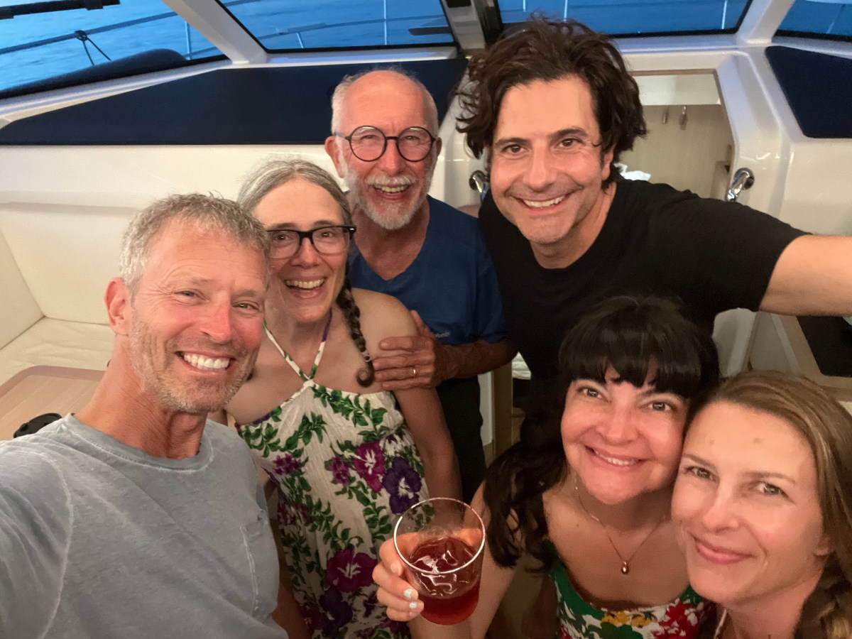
Our first night back in the area we anchored off a small island called Meek’s Patch, located between St. George’s Cay (Spanish Wells is the town on that island) and North Eleuthera. Peter and crew arrived just after us and we spent the afternoon and evening onboard getting to know his friends Michael, Nila and Wendy. We had a great time and they fed us freshly caught mahi! Who knows how long we would have stayed chatting if the thunderstorm hadn’t threatened and sent us scurrying back to our boat. It ultimately amounted to only a sprinkle.
Over the following five days we did some snorkeling together, took Nila to Preacher’s Cave with us, and shared dinner with First Edition four more times. It was usually them providing us with freshly caught fish from that day’s spearfishing. We contributed potato salad once. On our final night together, I made a chicken stew in our slow cooker and we brought it to their boat. After dinner we got to spend a mosquito-free night hanging out in the bow on Peter’s big boat bean bags, chatting the hours away. As always, it was a bittersweet farewell with the promise of seeing each other next season. We know we’ll connect with Peter at least, because he’s usually stationed in Georgetown and we will be heading there next season. Dave & I were up the morning they started their trek back to Georgetown, so we got to bid them fair winds and following seas with air hugs one more time.
I mentioned Preacher’s Cave. The reef on the north side of North Eleuthera that wraps around toward Harbor Island to the east is called Devil’s Backbone. Many ships have wrecked there. In 1684, a group of British from Bermuda set out seeking religious freedom in the Bahamas. Their ship wrecked on the reef. Everyone survived and they slogged their way ashore and found refuge for many months in this cave and the surrounding area. One of their members salvaged their boat (or maybe it was their equivalent of a tender) and sailed to the Carolinas area of the US, got provisions and made it back safely to the Cave. These folks eventually created a settlement in the area. I find cruising challenging enough in this modern era; I can’t imagine leaving one’s home for foreign, unsettled areas like they did!
When we weren’t hanging out with the First Edition crew, Dave and I did some solo snorkeling, renewed our cruising permit at the Spanish Wells Customs office, got one of our propane tanks refilled, got some groceries and more liquor, used the WiFi at Wrecker’s (restaurant at Yacht Haven Marina) for Dave’s STEM Guitar meeting when the cell service went down on the island one afternoon, listened to a couple of Bruin’s playoff games, and I rested my back. I did a little too much snorkeling and my back was horrible for about 3 days (had to resort to taking Flexeril). Once First Edition left, we moved to an anchorage on the south side of Russell Island just outside the entrance to the Spanish Wells harbor (about a ½ mile dingy ride into the public dock). We were there for four days1h5 v doing boat chores, running errands ashore when necessary, had a lot of hammock time, ran into some friends we met in Bimini last season, and were constantly checking on the status of our generator part. It finally arrived the afternoon of the 12th! We picked it up, ran some final errands, returned to Lady and hauled anchor around 3:30 to head back to the anchorage above Current Cut. Anchored by 5:30pm and Dave installed the new part. It did not solve the problem. Damn! A whole bag of Doritoes and a movie in the hammocks as consolation. The next morning, Friday the 13th, we headed to Hatchet Bay.
That wraps up Spanish Wells, and since I’ve already written about Hatchet Bay, my next post will probably pick up with the stop after that, which was Alabaster Bay, unless something else comes to mind. Until then, stay safe and take care of each other.
I’m bombarding you with posts this season! I’ve been in the mood and have had the time. It’s a good use of passage-making time. Most of our passages have been 2-3 hours with an occasional longer one. Today we are cruising from South Palmetto Point to Rock Sound Harbor, about 23 nm and 6 hours. It’s a good time to get ahead.
I’m going to back up to late April/early May when we were still in the Spanish Wells area. If you’ve been following us this season, you know my folks left on April 26th to return home. After we saw them off, we dropped the dock lines at Yacht Haven Marina and cruised to the Atlantic side of Egg Island to do some snorkeling because the seas were actually calm on the ‘outside.’ We snorkeled a couple of times on our own. After our second day of snorkeling we stopped by a new catamaran in the anchorage, SV Breathe, and chatted with Jason & Monica for a bit, arranging to join them for appetizers and sundowners on their boat later in the day. We did do that, and had a great time with them and their buddy boat friends, Cindy & Ron on @SV Reef’n It!
The next day we all snorkeled together. There was a bit more swell and lower visibility, but we still saw some great stuff. Jason takes amazing underwater photos; check out his web page or Facebook page @BreatheSailDive. That evening we had them all over to Indigo Lady for appetizers and drinks and a tour of our boat. They were also able to give us some intel about things to see and do on our way along Eleuthera, which has paid off in spades. We exchanged social media contacts so we could stay in touch, and they headed back to their boats a little after 8pm. Cruisers lament- meet cool people and then have to part ways (I’m sure I’ve said that before). They were heading off for the Abacos the following morning. Sigh. Hopefully our paths will cross next season.
On the last day of April, we moved to anchor off Current Settlement on the southern end of North Eleuthera. This put us in position to pass through Current Cut, between North Eleuthera and Current Island, with the proper tide because it can have a wicked current a boat like ours doesn’t want to go against. We walked through the tiny settlement to sit outside their library, closed that day, to use their WiFi. We were still having data issues at the time, so we took any chance at free WiFi we could get.
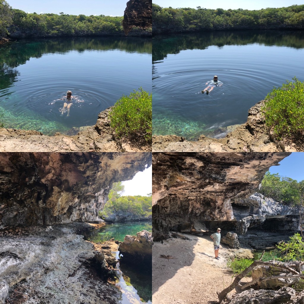
Passing through the cut the next morning was smooth, but the cruise to the Glass Window anchorage was a bit bumpy; not horrible, just not comfortable. It was a nice, calm anchorage though and we arrived in time for lunch followed by a walk ashore. We landed the dingy on the beach and followed a short trail to Queens Hwy to find we were directly across from one of the natural wonders we wanted to see- Queen’s Bath. This is a large area of basically very large tide pools carved out of the limestone from years of bashing by the sea. One can only go down into the baths at low tide and as long as the waves aren’t still crashing and spraying. We got the low tide, but the sea was quite active and we didn’t have the best footwear to climb down anyway, so we appreciated the beauty and awesome power of nature from the top.
We next walked a little further north to Glass Window Bridge. This is a very narrow isthmus just north of Gregory Town and east of Lower Bogue where you can see simultaneously the Atlantic on one side and the Bight of Eleuthera on the other. The Atlantic side sports 80-foot cliffs. In the 1800s it was topped by a rocky ledge (Winslow Homer painted this), which has long since been destroyed by hurricanes. The succession of manmade bridges haven’t fared much better over time. There is no reef to break the waves from the Atlantic side, so storms at sea often create waves that funnel themselves into the narrow Atlantic-side cliffs throwing up waves that wash over the bridge to the Bight of Eleuthera on the other side. Over the years they have occasionally taken an unsuspecting car and/or person over with them (here’s one such story). We were fortunate to see it on a calm day, so we could safely walk across it to take pictures from both sides. My pictures don’t do it justice.
After Glass Window we started our walk back to dingy but decided to go a little past it to see if we could find the restaurant/bar rumored to be nearby. Half a mile later we were sitting at Daddy Joe’s enjoying conch fritters and mac ‘n cheese sticks, along with a drink called a Kerpunkle, which we learned is Bahamian slang for shit-faced. Aptly named, because the drink was strong with rum. Yum! Our ‘snack’ was large and late in the afternoon, so dinner on board was cheese and crackers and fruit.
We’d planned to go back to Queen’s Bath the next day, but dingy needed a patch repair and we wanted to give it a solid 24 hours to set before using it again. So we stayed aboard all day. I made English muffins and did three loads of laundry while Dave patched dingy and did some other stuff. We lazed away the afternoon in the hammocks. The following day, May 3, we moved back through Current Cut to the Spanish Wells side. More about that in my next post. For now, enjoy this video slideshow of the sights described here, stay safe and take care of each other.
Our final excursion at Hatchet Bay was to Sweetings Pond, location of the proposed Seahorse National Park. It is a land-locked pond up to 45’ deep in some places, connected to the ocean somehow underground. It has a diverse array of sealife, minus the predators, which makes it an important refuge for the resident species, especially the seahorses. I found a 2020 Discover article about it that you can read if you like. It’s encouraging to know that the Bahamians are planning to protect this sensitive area and its life, while still allowing eco-sensitive use of it.
Thank you to SV Breath and SV Reef’n It for the intel on how to find this place and what to expect when we got there. There is no signage for Sweetings Pond on the main road and they gave us landmarks to look for. They also told us about the snorkeling rules we couldn’t have known about otherwise until it was too late and we were on site.
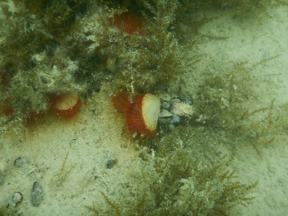
We walked the 1.5 miles to the pond, read the rules, then carefully got in. It was not the best day to snorkel due to the solid overcast, but it was still quite enjoyable. We spent about 40 minutes tooling around along the edges where it was shallowest, about 10’ (Dave went a little deeper). We saw one seahorse. Technically, Dave saw it. Despite his shining the dive light on it and pointing at it, I couldn’t discern it as a seahorse separate from the plant life it was hiding in. Alas! We did see numerous fish like we’ve seen diving some of the reefs; bivalves with bright orange, feathery mantles; fast-moving brittle stars; lovely, white nudibranchs; large crabs hiding under the overhangs; good-sized gastropods. A very worthwhile trip!
Every once in a while, we’d poke our heads above the surface to track the dark clouds that had been fairly far off when we started. They got closer, kicking up the wind and creating a bit of chop on the surface, the darker clouds reducing visibility. We got out of the water, put all our wet gear in the canvas bag we brought, stowed anything we wanted to keep dry in the drybag, donned our coverup gear, and then it started raining just as we set off back toward town. We knew this was a possibility when we set out on this adventure and decided that getting caught in the rain before or after snorkeling wasn’t a bad thing. In fact, we appreciated the free fresh-water rinse. Two very kind people stopped to ask if we wanted a ride, but we declined. No sense soaking their car when it was a fairly short walk. It only rained for about half of the walk back and started again just as we reached the dingy, a sprinkle really. We rinsed our gear and the rain got heavier, so I stayed out to hang our salty clothing and sandy towels and got my hair good and rinsed of the salt.
When I was done, I dried off, changed and Dave made us hot cocoa with dark rum, which we enjoyed while munching on banana bread and playing cribbage. It rained most of the rest of the evening, so we spent it inside playing cribbage, listening to the news, eating yummy pizza, and watching a movie.
I got a handful of decent pictures and put them in this slide show. I struggle with free-diving, so my photos are all from the surface, which limits what I can capture. Enjoy, stay safe, and take care of each other.
Sorry it’s been so long since I’ve posted. When I was in the mood I didn’t have the time, and when I had the time I wasn’t in the mood. Go figure.
The two coincided today- my mood and time, that is. Dave and I are sitting on Wrecker’s deck enjoying some yummy conch fritters and fruity rum drinks while we steal their WiFi so Dave can attend a meeting. The BTC tower (their cell service) went down sometime today, so we couldn’t connect to anything from Indigo Lady, who is anchored between Gun Point and Ridley Head. So here we are and I’m killing time, productively.
Wreckers is the restaurant for Yacht Haven Marina in Spanish Wells, St. George’s Cay Bahamas (part of the Eleuthra string of islands, at the northwest end). We’ve actually been here quite a while. Let me back up and fill you in.
Dave and I and my parents flew from Boston to Nassau April 6th, stayed the night, then caught the AM flight to Great Harbor Cay (Berry Islands) to rejoin Indigo Lady on the 7th. Yay! We were in the marina 5 days doing boat work, then moved to anchor off Bullocks Harbor on the west end of the island for a couple of days. We moved around to Great Harbor (below the Stirrup Cays, owned by Royal Caribbean and Norwegian cruise lines) for another couple of nights. On Easter Sunday we crossed to the west side of the southern end of Great Abaco Island and anchored in Cross Harbor (not a harbor in the real sense) for the night. Monday we headed southwest-ish to the Eleuthra chain. We anchored off Royal Island for the night and the next day headed into Spanish Wells harbor and picked up a mooring for 6 nights. Great town with enough stuff to do ashore as the wind blew hard. We enjoyed several lunches ashore and a couple of take-out dinners. We toured the island by golf cart, swam at the beach on the north end of the island, got a tour of the tiny historical museum, and relaxed. The night of the 25th we left the mooring and picked up a dockside spot at the marina to make it easy (and dry) to get my folks ashore for their flight next day. We availed ourselves of the laundry and the gorgeous shower facilities.
While still on the mooring we met Peter who stopped by to ask about our solar electric catamaran. Small world- he has a solar electric catamaran, built that way, not converted like ours. Small world! His was on the lift in the boatyard while work was done to it, by both him and some folks he hired to help. We shared dinner at Wreckers one night, and we made him pizza aboard Lady another night. He is a kindred spirits, so we have spent a bit of time with him in this area, but more about that in another post, because Dave’s meeting is almost done.
We saw my folks off on the 26th. Their trip home entailed a ferry-taxi-plane-taxi-taxi-plane-bus-car over two days. A ferry and a taxi got them to North Eleuthra Airport. A taxi got them to their Nassau hotel that night and another back to the Nassau airport the next morning. They flew to Boston, took the bus to Portsmouth and drove our car to their house (we left it there at the start of the trip).
And I’m out of time! I’ll give you all some more detail about our experiences in a future post. Until then, enjoy the sunset picture, stay safe, and take care of each other!
While in the Abacos from late May through mid July of 2021, we dove 10 times on 5 different reef systems. Two were small reefs inside the Sea of Abaco, that’s between Great Abaco Island and the small barrier islands to its east. The other three reefs were on the Atlantic side of those barrier islands, but we always dove the leeward sides (facing the barrier islands) because the conditions on the Atlantic side were either too choppy, or there was no place for us to anchor Indigo Lady and it was too far to dingy.
I always enjoy being under the sea watching the fish school along the coral heads, but this series of dives seemed more desolate than our Florida Keys dives back in August of 2020. I went back through the videos from our Florida Keys dives and finally realized what had been missing in the Abacos- fish! Okay, we saw fish in the Abacos, as you’ll see in the video, but we saw far fewer fish, less variety, and rarely any large fish or sharks. I would say the coral was about in the same condition both in the Abacos and Florida Keys, though perhaps a little worse off in the Abacos. I suspect Hurricane Dorian (early September 2019) had something to do with that. Still, there were fish to see, and I do find it peaceful to watch them from inside the fish tank, so to speak.
Fowl Cay National Park
The video that follows is a compilation of five dives done in Fowl Cay National Park over three days in June (two in early June, one in late June). The picture at the top of this post shows the area we explored.
The park was established in 2009. It used to have around twenty dive moorings one could pick up (with a small boat, not Lady’s size), but Hurricane Dorian removed many of them. There were about 6-8 left, or reinstalled, on the Grouper Alley/Flywheel Bay side, labeled in purple on the picture above. We dingied to these from Indigo Lady, which was anchored on the inside of the north end of Fowl Cay. When we dove the Twin Reefs/Tombstone area, labeled in green, we anchored Indigo Lady in a tongue of sand near the anchor mark in the picture and launched hookah from her sugar scoops (the stern steps).
Now settle back and listen to me breathe through my regulator as you as you enjoy the giant fishbowl of Fowl Cay National Park.
We’re still home. We hope to be able to return to Lady in early April; fingers crossed. Until then, I plan to post once a month.
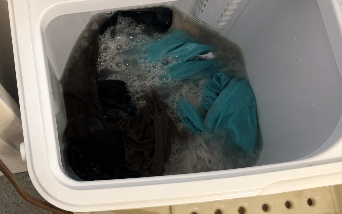
This month is a flashback to this past July when we were in the Bahamas and I had the idea that it might amuse you to see how I do laundry on Indigo Lady. At this point you’re either going to keep reading and then watch the video, or close your browser and wait for my next post. I won’t be offended if you opt for the latter.
Doing laundry on the boat requires some planning. It takes more of my time and attention, and it requires the right timing and weather conditions. Unlike doing laundry at home, I cannot just load the washing machine, go do something else for an hour, switch to the dryer and leave the dried load there until I need the dryer again. Washing the laundry onboard requires my full attention for 60-90 minutes per load, or at least setting timers so I don’t forget what I’m doing. Then there’s the fact that our “dryer” is the sun. The whole process needs to happen during daylight hours on a single day so everything is dry before the sun goes down.
These are my basic criteria.
We need to have enough fresh water in our tanks or I need to do laundry when we’re running the water maker. Each load uses about 20 gallons (maybe someday I’ll actually measure this). Our tanks hold 160 gallons.
I need a sunny morning and afternoon, preferably with a breeze but not a big wind. Less than 10 kts of wind is preferable, though sometimes I don’t have much of a choice. The more wind, the more clothespins I need to use and the more I worry that something will blow overboard (it’s happened).
I like to start around 9 or 10 am, especially if I have to do more than one load. Even if rain isn’t forecast, there can still be showers in the late afternoon/early evening due to local heating/cooling cycles, so I want the laundry dry and back inside by then.
This video demonstrates the actual process of doing laundry with our setup. I squeezed it into 2.5 minutes thanks to iMovie’s speed feature. If I left out anything you’re wondering about, ask in the comments.
We’re safely back home. Let me back up and get you from our final days in the Bahamas to now.
I left off with the day before we were to return to Bullocks Harbor at Great Harbor Cay, and I promised to tell you about the repair Dave was working on. I’ll start with the repair.
Our holding tank wouldn’t pump overboard. Worse yet, after some testing and troubleshooting Dave suspected the tank had become pressurized due to a blockage, most likely the intake to the macerator pump that pumps the tank overboard. A full, pressurized holding tank is bad because whatever needs doing to fix it requires opening the system, resulting in sewage leaking into the boat. Doesn’t that sound fun? Inevitably, when Dave initially opened things up, there was a little spray, but very minimal (I’ve read other cruisers’ horror stories). After that he was able to control the leakage so that it leaked into the bilge (that’s below the floors) which drains overboard. The blockage was where he expected, thankfully, and he eventually cleared it using a hose and pressurized saltwater (which forced more sewage into the bilge). Then he had to replace the pathetic macerator pump that had been problematic for a while anyway. I don’t know how he did it. It was a stinky job and I had to stay in the breeze in the cockpit the entire time to avoid getting sick. Dave’s a trooper! All told he spent a little over 3 hours on the repair and cleanup, that includes cleanup of himself. I followed his cleanup by mopping the floors and walls in that area with bleach water. Glad that’s over!
The following day was Sunday and we returned to Bullocks Harbor. Monday we met the Immigration officer at the marina and extended our visas. We dropped by Brown’s Garden later in the afternoon for snacks and drinks and a final conversation with the owner, Ronny, before we left. That was our last bit of fun for the trip. The rest was all work.
We were monitoring tropical storm Fred and decided that if he were to hit the Berries, it would likely be the coming weekend, so we changed our flights from Saturday to Friday hoping to stay ahead of Fred. (Fred ended up staying far enough south to have no significant impact on the Berries.) Then we changed our inn reservation to match and started preparing the boat and ourselves for our departure. We got a good amount of work done Tuesday while still at anchor in Bullocks Harbor where we had a delightful breeze coming through the hatches. Wednesday morning we brought Indigo Lady into the marina to get her tied up properly for the remainder of hurricane season and to complete the rest of our closeup tasks. We also got our Covid tests, which are required for re-entry to the US by airplane. Conveniently, the woman who conducts these tests is at the marine M-F starting at 10am. Much of Wednesday and Thursday are sweaty blurs- 8 hours each day dripping sweat the whole time. There was a breeze, but we had to go out to the cockpit to avail ourselves of it because it was from the wrong direction to blow into the boat. Thank goodness we’d booked the inn, which was mere steps from the marina, because it had blessed air conditioning plus a small fridge and microwave. We had prepared dinners in advance and were able to reheat and enjoy them in the comfort of our room at the inn. And we could take real showers! By 5pm Thursday, Lady was buttoned up and we waved goodbye to her.
Friday morning a taxi took us to the tiny airport and our 8am flight arrived about 8:30 and departed for Nassau by 8:45. Fortunately, the Nassau airport wasn’t very busy and, despite what looked like long lines, we made it through flight check-in, security, and US Customs pre-clearance in time to sit for about 45 minutes before boarding our Bahamas Air flight to Fort Lauderdale. We were back on US soil by 12:30, in our rental car by 1:30 and at my cousin’s house in West Palm Beach to retrieve our car by 3:30 after a quick lunch at Five Guys (oddly, I was craving a burger and fries, go figure). We chatted for about half an hour with my cousins then headed to our hotel where we took much needed naps. Dave stayed in for the night while I went to meet my cousins Susie and Sarah for dinner at an outdoor restaurant nearby. It was a brief get together, but most welcomed. Saturday morning we started our 2-day drive back to NH, stopping for the night in Rocky Mount, NC. We finally arrived home at 10:30pm a week ago Sunday night. Phew!
We’ve spent the past week getting our land lives restarted and recuperating from the hot, sweaty, busy final days in The Bahamas followed by the long drive home. We did see my family soon after our return. Since we’d been on two airplanes, I ate at a restaurant (even though it was outside, it was in FL), and there was very little masking at any of the rest areas or takeout restaurants at which we stopped, we decided to take Covid home tests before seeing my family, just to be extra safe. Negative- yay! Most of the grudge work of returning to land life is done and now I’m itching to settle back into my land routine and to reconnect with friends and family on a more regular basis.
I’ll probably post once every 2-3 weeks while we’re at home. I believe I promised some diving video slideshows, and I will get to those. I have a couple of other posts planned, such as one displaying the art of the art trail we walked at Manjack Cay (I took a lot of pictures), and I want to create a map of our travels this short cruising season. If there’s anything you’d like me to post about, let me know in the comments section or email me and I’ll try to accommodate your request.
Until next time, stay safe and take care of each other!
Grab a beverage and find a comfy seat; this is a long one.
The Berry Islands are a small chain of islands about 57 nm (nautical miles) SE of Freeport on Grand Bahama and about 72 nm east of Bimini (or about 115 nm east of Miami). The island chain is bordered by the Northwest Providence Channel, the Northeast Providence Channel, and the vast, shallow Grand Bahama Bank. The northernmost islands are Little and Great Stirrup Cays, owned by Royal Carribbean and Norwegian cruise lines, respectively. Royal has dubbed Little Stirrup as “Perfect Day at Coco Cay.” Cocoa Cay is full of beaches, beach bars, water slides, and even a hot air balloon. Great Stirrup is set up as more of an adventure island with ziplines and such. This is from what we’ve read and seen as we’ve cruised by them (7 times thus far). The only town in the chain is on Great Harbor Cay, just south of the Stirrups, population around 400. The Stirrup Cays provide employment for a very large portion of the town. One local we spoke with estimated about 75-80% of adults are employed by those cruise lines in some way. Currently, the cruise lines do not offer excursions to Great Harbor Cay. In town there are two small grocery stores, several restaurants, a marina (one of the best hurricane holes in the Bahamas), several rental properties/inns, an air strip, a bunch of privately owned houses outside of town (owned by foreigners), and lots of friendly people. At the southernmost end of the island chain is Chub Cay, which is a big sport fishing spot that gets a lot of traffic from high speed powerboats from Florida, plus they also provide sport fishing charters for those who fly in. The inbetween islands are either uninhabited or privately owned. I’ll let you look at a map and try to count the number of islands that make up the Berries; I stopped counting at 45. The Berries are not a tourist hot spot, except for Chub Cay, but they do have their regular visitors by land and sea who appreciate them for their quiet, remote anchorages and friendly town.
From Explorer Chartbook: Near Bahamas
If you’ve been following my blog for a while, you may recall that Dave and I were here with my folks, on Indigo Lady, back near the start of the pandemic in late March/early April of 2020. There are worse places to be stuck for two weeks during uncertain times, but I’m glad we’ve had the opportunity to return and enjoy them differently this year. Yes, the pandemic still rages on, but the Bahamas figured out a way to reopen their borders to the much-needed tourists. Just like at home in the U.S., we follow whatever mandates each island group has in place at the time.
You don’t come here for the abundant daytime activities and the night life. This is a place where you meet and talk with the locals and get to understand their way of life. When we were here in late May this year, we biked the southern half of the island, walked about town, and met Ronny and Gaynell who own and run Brown’s Garden restaurant. We returned here from the Abacos in mid July and spent a few days anchored off town again. We returned to Ronny’s & Gaynell’s restaurant. The day we lunched there, Ronny invited us to come back for a cookout that evening that was a sendoff for his wife. She was promoted and would be spending a couple of years mainly living and working in Nassau, visiting with Ronny on weekends as one or the other of them would fly over to the other island. What a sacrifice! But they have plans and are working towards them. It was very sweet of Ronny to invite us and Gaynell introduced us to his family. This is the kind of experience one has on an island like this. Had we been here earlier in the cruising season, we would have availed ourselves of the socializing that goes on in Great Harbor Cay Marina. We heard that they do a group cookout on Fridays and pizza takeout on Saturdays. Alas, the marina was mostly empty when we returned in July; only a few boats stopping for a night or two.
We left Bullocks Harbor the morning of July 21st and started our trek down the eastern side of the island chain to spend some time at those quiet, secluded anchorages. We weren’t in a rush, so we took three days to get to Little Harbor Cay, the furthest south we planned to go. My post from July 24th takes you from Bullocks Harbor through our running aground and to the anchorage behind Little Gaulding. We spent two nights at that anchorage, which we did not enjoy because of the current and opposing swell. The morning of the third day we caught the rising tide down to the northwest end of Little Harbor Cay where we anchored on the west side of the island just below the NW point. It was another sandy-bottom, clear water anchorage and well protected, so it was blissfully calm. There was only one (very large) boat moored bow and stern. We stopped by briefly to say hello as they were heading off in their tender one morning. Turns out the owner of the boat also owns Big Gaulding Cay and they were heading over for a cookout. He graciously invited us to come over, but we weren’t in the mood for a hot day ashore so we declined. We spent three nights anchored here.
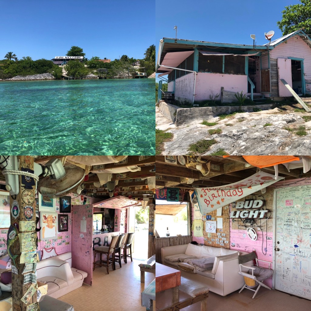
While at this anchorage, we found the little trail across to the Atlantic side and walked the beach. We dinghied over to the west side of nearby Comfort Cay to explore the underwater blue holes someone had told us about. Dave explored the blue holes snorkeling. We weren’t sure about the holding for dinghy’s anchor, so I stayed aboard just in case. I wasn’t terribly interested in this blue hole anyway. When Dave finished, he said he was glad he checked them out, but wasn’t interested in trying to move Lady over there to dive them with the hookah. He’s done his share of deepwater diving and is more interested in the reefs these days. After the blue holes, we decided to act upon the real reason we chose to go to Little Harbor Cay- the opportunity to eat at Flo’s Conch Bar. The restaurant was established in 1993 by Chester Darville, who returned to the island of his upbringing after almost 20 years. His mother, Flo, was the head chef until her passing in 2011. The family and workers are the only inhabitants on this island and they occupy a couple of buildings next to the restaurant. Other than a “camp” on the north end of the island, there are no other signs of civilization. Flo’s is not always open, so one has to make a reservation in advance. Unable to reach the restaurant by email, phone, or VHF, we stopped by after our blue hole excursion to arrange to have lunch there the following day. The restaurant is renowned for its Bahamian dishes and they did not disappoint! We did in fact have lunch there the following day, having arranged to have “a little of everything.” We enjoyed conch fritters, lightly battered and fried fish fingers, coleslaw, and Bahamian peas and rice, accompanied by a rum punch. Delicious! We also got to enjoy conversation with a lovely family who was also lunching there. The son/grandson (about 9-10 years old) regaled us with his knowledge of all things science. He was a joy! Lunch was so huge that we ended up bringing leftovers back to Lady that served as lunch the next day. “Dinner” later that night was cheese, crackers and pepperoni, quite late because we were still full from lunch Flo’s was certainly worth the trip!
Flo’s Conch Bar
The following day we caught the afternoon rising tide back to Hoffmans Cay where we anchored and stayed for 10 days. Hoffmans is uninhabited and the epitome of a quiet, remote anchorage. The only other boats we saw were a half mile or more away and anchored either off Little Gaulding or White Cay. A bit different than last year when we shared the anchorage with several boats also waiting to see what the pandemic would bring for cruisers. It is also much hotter here in July and August than it was in late March/early April. The temperature might get as low as 84-85oF overnight and as high as 89oF during the day (only saw 90oF once). There was a period of several days with very little breeze, making it feel even hotter. The days kind of run together at this point. Most days we did at least one thing off boat, but we spent a couple of really hot, nearly windless days onboard in the shade of our solar panel roof, in the hammocks, dipping into the water to cool off as necessary. Most afternoons were spent in the hammocks, followed by dinner and then either games, a movie, or the Red Sox. We also tended to basic chores and some projects.
Over the course of our stay at Hoffmans we walked to and took a dip in the blue hole on the south end of the island. This blue hole is on land and is fed by the ocean from an opening on its bottom. Someone we met said it’s around 55’ deep. We walked the Atlantic side beach twice, the second time visiting the stranded power boat we saw last year. It has moved! We dinghied into a little bay full of sea turtles and up into the mangrove river on the rising tide. Last year we saw a bunch of fish among the mangrove roots, but this time we saw only a small school of needlefish and a couple of other small fish. Last year we’d seen a school of bonefish in the bay, so this time Dave set up to cast for them but, alas, there weren’t any. We snorkeled the ledges around two small beaches in sight of our anchorage. We didn’t see as much big life this time, although we did see a couple of trigger fish and a 5-6’ shark, which we thankfully only caught a glimpse of before it swam off. It wasn’t close enough long enough for us to identify it properly, but it was probably a reef shark. We walked the long, northernmost beach (also anchorage side) a couple of times. It’s only a “long,” one-mile beach at low tide. You can wade out into the water quite a way in a couple of spots and be standing on exposed sand. At the far end there is a remnant spit of coral that sort of forms a little bay where we saw a baby shark, very whitish and only about 2’ long, likely a juvenile and no idea what species. These walks also revealed one good sized ray, one barracuda, and several trigger fish, all right up in the shallows, plus a bunch of yellowfin mojarras (had to look those up) and little crabs that would scurry away from our feet and burrow into the sand. Along the shore there were many curly-tailed lizards, laughing gulls, plus we saw some sort of heron and an osprey. Our last day at Hoffmans we decided to snorkel off the long beach to see the sealife from in the water. Of course none of the big stuff graced us with their presence that day, but it was a fun and cooling way to spend a hot couple of hours.
Before we knew it, it was time to head back to Great Harbor Cay. As I write, we are two thirds of the way back. We spent Thursday night anchored off Soldier Cay again. This time we snorkeled to the beach and around the southern point and took a brief walk ashore. Last night and tonight we are anchored in Great Harbor behind the Stirrup Cays. Tomorrow we return to Bullocks Harbor. Monday we will go to Immigration to renew our expiring visas; we’ve spoken to the immigration officer, who is expecting us. Then we start the process of closing up and securing Indigo Lady for the next 5 months or so. We’ll do some of the closeup prep at anchor in Bullocks Harbor where we can benefit from the breeze, but the final couple of days we’ll need to be on a slip in the marina. We booked a room at the nearby inn for those final two nights.
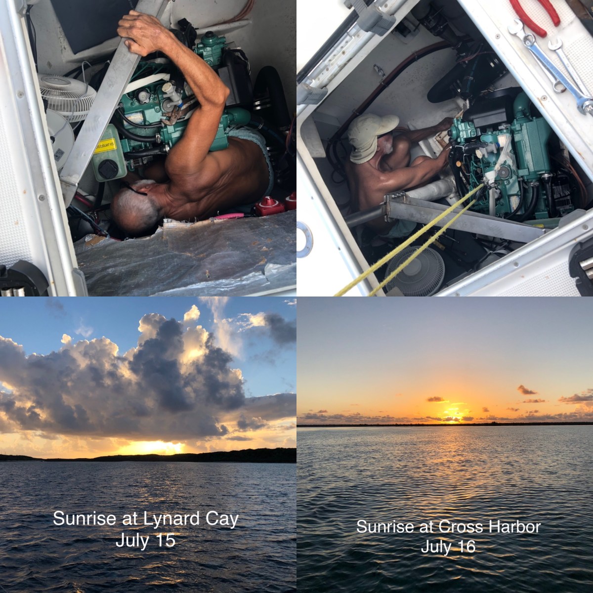
I’m not sure if I’ll have the time or energy to post next weekend. Maybe I’ll knock off something when we’re back in the U.S. and at the hotel next Saturday night. Dave is having an interesting day today, with a couple of troubleshooting/repair jobs, one of which I wouldn’t wish on anybody. You’ll have to wait until next post to find out what that is.
Until then, stay safe and take care of each other!
Our stint at Manjack Cay was our last touristy hurrah before heading back to the Berry Islands. We left Manjack the morning of Friday, July 9th and arrived at Great Harbor Cay in the Berry Islands mid-afternoon on Friday the 16th. Our focus at this point was readying ourselves and Indigo Lady for the two days we would take to get back to GHC and we decided to do most of the preparations at Marsh Harbor.
We arrived at the little bay anchorage just outside of Marsh Harbor on the afternoon of Saturday the 10th. We spent three nights and three very busy days there. Sunday-Tuesday were all work, especially for Dave. In late June Dave discovered there was a leak in the port engine room around the rudder post. It was small, but no leak through the hull is good and small ones have a habit of becoming bigger, so Dave wanted to repair it before heading back to GHC. That repair took from 9:00 am – 7:00 pm Sunday (some of that time was waiting for JB Weld putty to dry). Monday morning we walked to Maxwell’s Supermarket for some final provisions. Back onboard I tended to the unpacking and moving around of provisions while Dave started cleaning our hulls. I made him stop about 2/3 of the way because it was late and he was exhausted. We barely mustered enough energy to heat leftovers for dinner and listen to music in the hammocks before bed. We got little sleep that night due to a storm that started around 11:30 pm and didn’t finish until after 3:00 am. Once again, the storm came from the only unprotected direction in the anchorage, making it bouncy and noisy with the waves hitting the hulls. We dragged ourselves out of bed just after 8:00 am Tuesday. Dave managed to finish cleaning the hulls after breakfast and I did some interior cleaning. Though tired, we decided to make the short 6 nm hop over to Hope Town knowing it would be a bumpy ride. It was, but it was short, and we were rewarded by a calm afternoon and night on a mooring and a final loaf of coconut bread from Vernon’s Grocery.
Wednesday morning we headed over to Lynard Cay. This was the first place we had anchored when we arrived in the Abacos in late May and it was now our launching spot for the return trip, retracing our steps around Hole in the Wall to Cross Harbor, then the following day from Cross Harbor to GHC. Lynard Cay to GHC is a 16-20 hour trip that we could do in a single shot, but I prefer to avoid overnight passages when they’re not necessary and it was not necessary in this case. The weather routing apps we use looked good enough to set out as planned at first light the next morning. We agreed that if conditions weren’t good we’d turn around and try again the next day.
As planned, we set off Thursday morning at 6:30 am, just as the sun was rising, and stuck our nose out into the Atlantic. The conditions weren’t perfect, but seemed doable, better than our trip up anyway. Conditions deteriorated about 2 hours out. We’re still learning how to apply all aspects of a forecast to a planned route. A forecast of 2-4’ seas from the SE with an 8 second period is based on the average top 1/3 of waves and assumes open water with no other influences; there can still be waves shorter or taller and from other directions. We did not account for the wind chop, which layers wind-driven waves over the predicted ones, and on that day the wind and seas were from different directions, which means we had waves from multiple directions- “confused” seas. On top of that, we were heading almost into some of the wave sets, which shortens the wave period making it bumpier. We chose to continue anyway for a few reasons. First, despite the bumpiness we were making better time than the trip up because the wind and some of those confused seas were more off our stern and giving us a bit of a push; it was only going to be an 8 our trip and we’d already done 2 hours. We knew when we made the turn to go around Hole in the Wall we would have the seas completely behind us and once around the point we’d be in the lee of Great Abaco where the water would flatten- that was another 2 hours of the trip. So I had 4 more hours of bumpy conditions to suffer through (the bouncing doesn’t really bother Dave). I’d taken one seasickness pill but should have taken two because I still wasn’t feeling great, mostly tired, and all I could do for 5 of the first 6 hours was stand and stare at the horizon waiting for the torture to end. Onward we trudged. I rejoiced when we made that turn to go around Hole in the Wall! We anchored in Cross Harbor by mid-afternoon and got a nap in before dinner (which I’d had the sense to prepare in advance) and we got a good night’s sleep. The next morning, Friday the 16th, was much better. We left at about the same time of the morning and had following seas the entire 8 hours. We were anchored in Bullocks Harbor by 3:00 pm and in the hammocks with celebratory drinks shortly thereafter.
We’re currently exploring the Berry Islands for the remainder of our time in the Bahams, which is quickly nearing its end. We have booked flights back to the US for mid August. We will pick up our car from my West Palm Beach cousins and start slowly driving home, stopping to visit family and friends along the way, assuming the stupid Delta variant of COVID doesn’t get any worse.
Next week I’ll tell you about our time in the Berry Islands. Until then, stay safe and take care of each other!
The photo is a spoiler. We ran aground yesterday. Oops!
We’re fine. Indigo Lady is fine.
I’ll back up a little to bring you up to speed.
We left Bullocks Harbor at Great Harbor Cay on Wednesday to hang out in the eastern Berry Islands for a while. On Wednesday we rounded the Stirrup Cays and decided it was a bit too bumpy to continue to Hoffmans, so we ducked into Great Harbor (not to be confused with the cay of the same name). Great Harbor is a shallow bay formed by the back side of Great Harbor Cay, Little and Great Stirrup Cays and Lignumvitae Cay. There were perfect conditions for this anchorage so it was nice and calm with crystal clear water over a sandy bottom. There was a cruise ship on Little Stirrup (aka Perfect Day at Coco Cay, owned by Royal Caribbean), but that is so far away it had no impact on us. We had the anchorage to ourselves. The water, being clear with a sand bottom, was cool and refreshing, a nice change from the warm, turbid waters of Bullocks Harbor.
Next morning, Thursday, we hauled anchor around 10am to head for Soldier Cay. It was another gorgeous day this time with good sea state and light wind, so the Soldier Cay anchorage was comfortable. We got another sandy bottom with clear, refreshing water. We walked on the tiny beach at low tide. The rocky north end, plus the small rocky islands north of Soldier are nesting areas for laughing gulls and other birds and they have chicks now. They were not happy when we dinghied along the shores to go snorkeling, and they let us know it by swooping over us. Fortunately none of them lightened their load over us. It was low tide rising for a shallow snorkel. If some of the reefs we’ve dived on were “nursery” reefs, this area was for “newborns.” We saw the standard reef fish, but most of them were so wee! There was a smattering of full-sized reef fish, but mostly tiny ones. So cute! Our big fun here was swimming along the rocky shore toward the cut, kicking as hard as we could to get as far into the cut as possible, then riding the incoming tide back inside. Fun! We did it twice.
Yesterday morning, Friday, we hauled anchor at 7:30am for the high tide through the shallow cut to Hoffmans Cay. We’d done this in reverse last year during the pandemic when we hung out at Hoffmans before heading back to the US. No problem. We cruised the length of Hoffmans and decided to try for the next batch of islands down for a more protected anchorage given that some squall activity was heading our way for this weekend into Monday or Tuesday, possibly from the exposed direction. We should have stayed at Hoffmans.
We were on the falling tide, about 60-90 minutes after high, when we had to navigate a short, shallow cut between Saddleback Cay and Big and Little Gaulding Cays. The shallow draft route marked on the charts conflicted with the notation that said to hug Saddleback about 20’ off its shore. We opted to steer closer to the route line. Mistake! Had we been one boat width (25’) closer to Saddleback we never would have grounded. Had we been half a boat width closer to Saddleback, port hull would have grounded, but we would have wiggled off using starboard. If we’d arrived at peak high tide instead of an hour after high, we wouldn’t have grounded. But ground we did. We were only moving 3 kts, there were no waves, and the bottom was sand and weeds over hard. So we just ground to a slow stop. Dave tried to back us off with the motors. Then he hopped in dinghy and tried to pull us backwards and off. Unfortunately neither effort worked, especially since we wanted to move backwards while the current was pushing us forward. Nothing to do but wait for the next high tide to float us off. The second high tide would also be about half a foot higher, so we knew we’d have plenty of water to float us off, and we were only 0.25nm from our intended anchorage. So close, yet so far!
We were very lucky that not only was it a soft grounding resulting in no damage, but it was also a calm day. We entertained ourselves with some boat tasks in the morning and early afternoon. About an hour before full low, Dave got into the water to walk around the boat to check for depths near and beyond the boat, and to check her hulls. She was sitting fine with no damage. Port was in shallower water than starboard. Deeper water was only about 20’ off our starboard and about the same behind us. We knew starboard would float first and were pretty sure the incoming tide would push us backwards. Dave kept tabs on the water level and when it reached dead low, marked the distance to waterline on our boat hook. This allowed us to check how quickly the tide was rising as the afternoon progressed. We retired to the hammocks mid-afternoon to read and enjoy a drink as the water rose. For once, they weren’t swinging.
Around 5:30pm, Dave noticed that the water was at the waterline on starboard and that starboard bow was bouncing up and down a bit- movement! For the next 20 minutes we sat at the helm station, watching and waiting as we slowly rotated toward starboard. We considered trying to motor the port side off, but then decided not to bother, mother nature was taking care of it. By 5:50pm we were fully afloat, started the engines and proceeded to the anchorage. Anchor down just after 6:00pm.
Phew!
We’ve learned some lessons with this. First, don’t ignore your gut instinct. Dave’s gut had hinted at maybe not attempting the passage on the falling tide; he ignored it. He won’t do that again any time soon. We also should have thought through the discrepancy between the charted shallow draft route and the notation to hug the Saddleback shore and at least split the difference between the two. I was on the bow spotting, which is important in shallow route areas, but with the current pushing us from behind, that hump we grounded on came up too quickly for us to respond, another reason to not tempt fate on a falling tide, even if it is only “shortly” after high. At least for today, those lessons have stuck. We had set an alarm for 7:00am intending to backtrack 2 miles to a more sheltered anchorage south of here. We awoke to overcast skies with 15 kt winds and 3’ choppy seas from the SW (of course, the exposed side of this anchorage). Today’s planned route would have passed through three shallow spots, two of which we were unfamiliar with. Bouncy water is not good crossing shallow areas, even on the high tide, because the bottom of a wave trough can bounce you off of the seafloor. Overcast skies means you can’t read the bottom as you proceed, also a bad idea in shallows. So despite this anchorage being a bit uncomfortable, and not certain our anchor won’t drag if a squall kicks up, it was still the lesser of two evils. Dragging isn’t fun, but we know how to handle that, and there’s deep enough water around us to give us time to respond to a drag even at low tide. Getting stuck in the shallow with squalls threatening would be very bad.
Next week I will backtrack to our final days in the Abacos and the two day trip that got us back to Great Harbor Cay, which is what I’d intended to cover this week. Until then, stay safe and take care of each other!