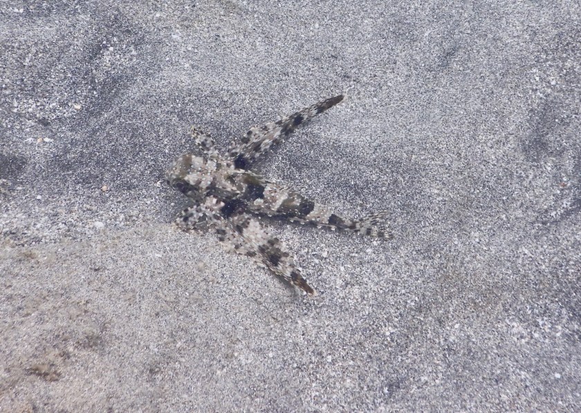
I had never even heard the name, flying gurnard, until the last day of our cruising season in June of 2024. Indigo Lady had been anchored in White House Bay at the southeastern end of St. Kitt’s for a couple of weeks. We had spent several of the latter days at anchor deep cleaning and otherwise preparing Lady to be hauled out for hurricane season. Each afternoon, we’d wrap up our hot, sweaty work somewhere around 3-4 pm and go for a snorkel in the anchorage. On our last day at anchor before heading up to the boatyard, we knocked off work as usual and suited up for a snorkel. We’d snorkeled the area a lot and would see the usual sea life suspects, so this time I decided not to take my camera. I joked with Dave that he should thank me, because it meant we’d see cool stuff. The joke was on me, because that one snorkel excursion revealed to us two banded coral shrimp, several constellations of cushion sea stars sporting 4-6 legs, a mass migration of whelk, a golf ball-sized octopus, and the prize of them all, a flying gurnard!
We were snorkeling over a shallow, sandy patch, maybe twelve feet deep. We both saw the creature at the same time and stopped to examine it. It sort of looked like a lizard fish, of which we’ve seen many, but not quite. Its pectoral fins were quite long, almost the full length of its body, and pointed backward. We popped our heads up and wondered aloud at what it might be, then stuck our heads under water again. Then the creature started to crawl! It looked like there were two tiny hook-like claws near where the pectoral fin joined the body. A crawling fish?
We popped our heads up again and wondered some more. Dave decided to dive down and encourage it to swim, so back down we went. When he flicked near its tail, the fish opened up “wings” (its pectoral fins) that were edged in a beautiful iridescent blue, and it “flew” across the bottom for several feet before settling again. We were determined to burn the image into our brains so we could identify it later back onboard. As soon as we dried off after our return to Lady, we pulled out our identification book and started searching. We found the flying gurnard. With that name, we searched the internet and found various other pictures that looked just like our fish. What a find! Too bad we could only describe it to people and show them other peoples’ pictures online.
Cruising season 2025 started in January. We spent a few days in that same anchorage, but only had time for a couple of snorkels. We did not see a flying gurnard. In early March, we were in the Îles des Saintes in Guadeloupe. While reading the section of our cruising guide about those islands, we read that flying gurnards could be spotted at Îlet a Cabrit. We snorkeled there four or five times over three days, and again in April once or twice. We saw several species we hadn’t encountered before, but no flying gurnard. Bummer! We kept our eyes peeled during every subsequent snorkel and dive, of which there were many, in Guadeloupe and later Antigua, but we never saw a flying gurnard. Until our last snorkel of the season…
We were back in White House Bay, St. Kitt’s by late May for an early haul out this year. It was a much shorter stay this time, so our close-up tasks were condensed to only three days. We were too exhausted at the ends of the first two days and did not snorkel, but we vowed to snorkel on our last day before moving up to the boat yard for haul out. Into the water we went on that last day, and this time I took my camera. We stopped at every patch of sand we crossed over, searching for the elusive flying gurnard. At last, it happened. We both saw the fish at the same time- lizardfish looking but with pectoral fins too long. We popped up our heads at the same time and planned for Dave to flick its tail and for me to have my camera ready with recording already started. So that’s what we did, and we got video! The fish just scooted away a bit from Dave’s first attempt, without opening its wings, but eventually, Dave coaxed it to display all its glory and I captured it on film. Quest complete!
So here are a couple of pictures and a video I took of the flying gurnard for you to enjoy. If you’d like to learn more about this fish and its unusual fins, go here.
We left Barbuda at 8:00am on May 4th to return to Antigua. There was a strange vibration around our starboard motor, so for half the trip we ran just using the port motor. Once we got into the calm waters inside Boone Reef on the north side of Antigua, we started the starboard motor again, because the vibration was only happening when we were slewing to the left during a roll over a swell, and the water inside the reef was flat. Dave later discovered that the vibration is due to something minor related to how the external pieces abut each other. It can wait to be fixed once we’re on the hard in St. Kitt’s.
We were anchored in Parham Bay, on the north shore, just before 4:00pm and shortly thereafter dinghied ashore to pick up a few items at the local market. We asked one of the fishermen where the market was and he gave us directions. It closed about 20 minutes before we got there. Bummer! There was supposed to be another market around the other side of town, but we decided not to walk that far lest it also be closed, being Sunday, after all. Plus, we were exhausted from our seven-hour cruise down from Barbuda, and it was hot. We’d come back in the morning.
It was a good thing we decided not to seek out that second market Sunday evening, because when we went in search of it the next morning, it was not where Google Maps and our cruising guide (which also had the wrong market name) had it marked. We did find it, however, thanks to the directions of another local, and procured the handful of items we sought. We went back to Lady and moved about three miles east to anchor off Great Bird Island. It was a much prettier and quieter anchorage than Parham Bay, which hosted a boatyard and a power plant, the latter emitting a low, persistent, rumbling sound. In addition, we could see the bottom at Great Bird. After lunch, we snorkeled some bits of reef in the shallow water off Great Bird. It was both depressing and a bit hopeful. We anchored dinghy in sand, but her stern was floating over an immense stand of dead staghorn coral. So sad. Looking closely, however, I noticed that there is new staghorn growth coming off the ends of some of the old, dead base. These bits were 6” long or less, but it’s a sign of rebirth. Coral grows very slowly; perhaps in the not too distant future this reef will thrive again (she says, hopefully, not really believing the words she types). At other parts of this shallow reef, there were also some soft and encrusting corals, also signs of hope.
The following morning started with rain and solid overcast, but by early afternoon the rain had stopped and the sun was peeking out occasionally, so we decided to snorkel again. This time we took dinghy to Whelk Rock, about ¾ of a mile from Great Bird. This reef is immense! It was at spots breaking the surface and got down as much as 15-20 feet in other spots. The base coral structure was, again, dead, but there was a lot of regrowth of soft and encrusting corals, and there were some fish, the usual suspects. Again, this reef system must have been amazingly beautiful in the not too distant past. 😔
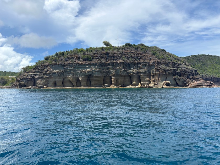
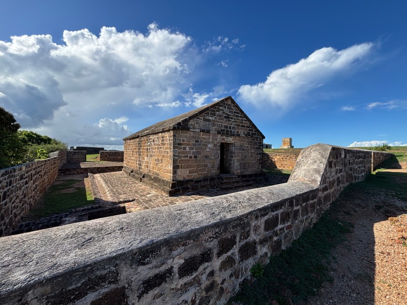
We’d had enough of mostly dead reefs, so the following morning we headed to the south coast to anchor in Freeman Bay, just outside of English Harbor, home of the historic Nelson’s Dockyard. Conditions were quite calm, so we were able to take the shorter route through a channel at the north end of the reef system, then cruised down the east coast of Antigua. It only took about three hours, so we were anchored in plenty of time to snorkel the Pillars of Hercules. The snorkeling, as expected, was pathetic, although we did see some good-sized fish, as well as scattered corals and sponges, the latter of which we had not seen on the other Antiguan and Barbudan reefs. The Pillars, however, are quite impressive. These limestone structures were carved out of the cliff by thousands of years of erosion by wind, rain and crashing waves.
Pillars of Hercules
We swam directly from Lady to the Pillars and back. Once we dried off, we made ourselves presentable and went ashore to the Port Authority to pay the requisite fees for staying in this anchorage. Both English and neighboring Falmouth Harbors, plus the land immediately surrounding both, are part of the Nelson’s Dockyard National Park, thus the fees. We paid a one-time per person entry fee for the park, a daily per person garbage and environmental fee, and a per-foot/per night boat length anchoring fee. Our 5-day/4-night total for three people was under $100 US. Not too bad.
After paying our fees, we bopped around Nelson’s Dockyard a bit so Ian could see it. Then, we walked the short distance to Falmouth and found a restaurant for dinner. Just as we were leaving the restaurant, it started to sprinkle. By the time we got back to dinghy, tied up at Nelson’s Dockyard, it was raining. By the time we got back to Lady, we were soaked to the point where we had to wring out our clothes. Then we had to make room for our wet clothes and ourselves inside, which we managed. It could have been much worse, because there were thunderstorms around us, but they, and their associated lightning, stayed away as we passed the wet evening inside playing cards.
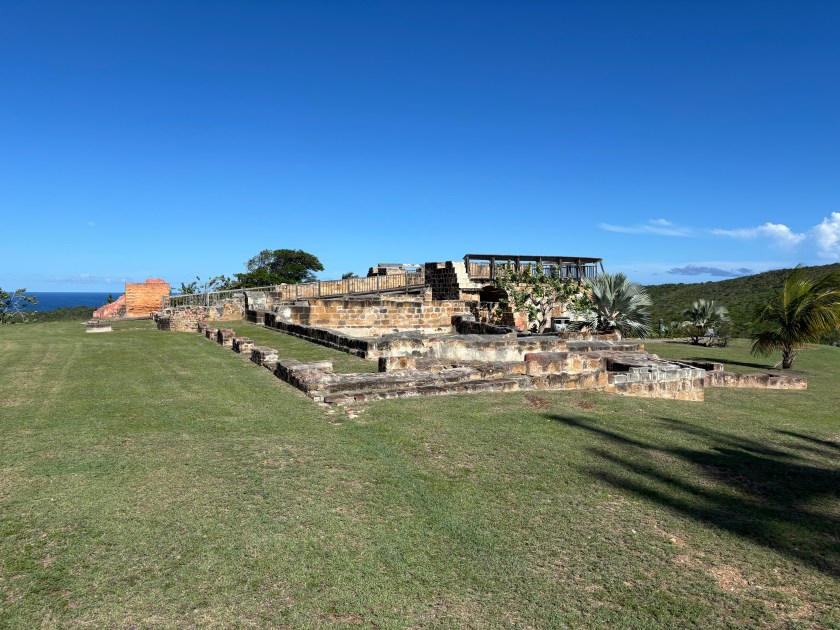
The Freeman Bay anchorage is small and very close to land, and therefore bugs, so we moved over to Falmouth Harbor the next morning, right after breakfast. There was a better breeze and we were further from land, but still only a short ride to a dinghy dock. Shortly after anchoring, we dinghied ashore to pick up our rental car, then we set off to tool around the island for the day. First we followed a largely coastal route across the south coast and up the west coast, stopping at a little place in the town of Five Islands for lunch. We inadvertently drove right through the busy heart of St. John’s after our attempts to circumnavigate it failed (thanks, Google Maps 🙄), then headed east/southeast stopping at Betty’s Hope Sugar Factory ruins to explore those. They had a concise, informative display about its history and that of the sugar industry on Antigua, and the remaining ruins are clustered nearby. It was worth the $2 US donation per person, even though we only got 30 minutes to tour it before they closed for the day. We continued back toward English Harbor to Shirley Heights Lookout for Reggae night, stopping to look at some of the Shirley Heights Fort ruins first. Dave and I had gone a few weeks earlier to their Sunday night music event, but didn’t eat because the line was hours long. This time, there were far fewer people and no line for the food, so we had a nice dinner, listed to the introductory steel drum band, and left before the Reggae even started. We were all tired, and our early departure got us back to Lady before it was fully dark.
Betty’s Hope windmill and old gears (on the ground)Block House at Shirley Heights
Yesterday we spent another day with the rental car exploring Antigua. We started by going to Clarence House which has served as home to British Navy Commissioners and later to Governors of the Leeward Islands. Sadly, they only do private tours on certain days, and Fridays was not one of them. So, we headed over to the Dow Interpretation Center to look at the limited remains of Fort Dow, and to watch the 15-minute audio-visual presentation about the history of Antigua and English Harbor. It was a good overview, but Dave and I had already learned the content when we visited the museum in St. John’s shortly after arriving here.
Fort Dow
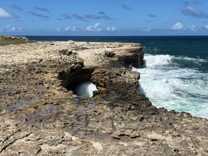
With our history lesson finished, we continued our driving exploration of the island by heading up to Devil’s Bridge National Park at the northeast corner of the island, stopping for lunch in Long Cove first. Devil’s Bridge is a low, natural limestone rock arch and surrounding blowholes, carved out by the crashing waves from the open Atlantic- nothing between it and Africa other than ocean. It was interesting enough. The seas weren’t that big, so the wave crashing was less impressive than I would imagine it is when the Trade Winds are higher. I took some photos, but our timing was bad for sun position, so they don’t really show the bridge well. Alas!
Devil’s Bridge
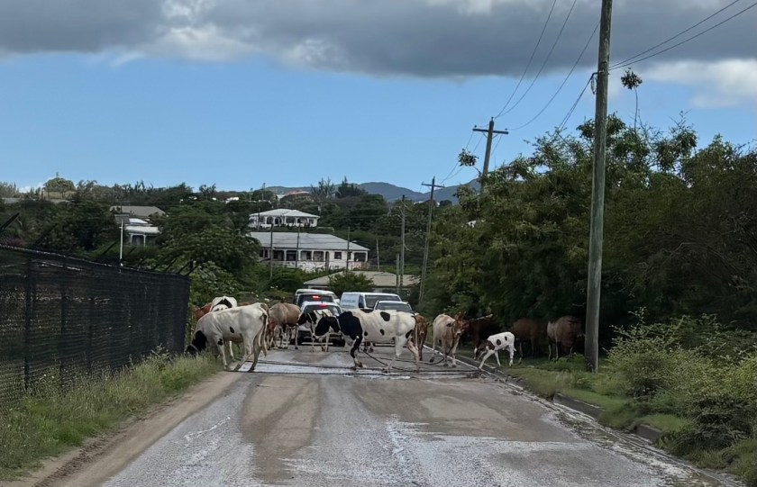
After Devil’s Bridge, we just tooled around the island a bit longer on the speed-bump and pothole-riddled roads. We attempted to reach Body Ponds Nature Park, but our attempts were foiled, at both its entrances, because Google Maps, at least on this island, does not distinguish between paved roads and unpaved/heavily rutted/almost washed out roads/cow paths. (Thanks again, Google Maps!) We gave up and headed back to Falmouth, stopping for a beer at a little craft beer brewery before heading back to Lady. (The boys report that the beer was “okay.”)
Antigua traffic jam 🙂
This morning we gassed up and returned the rental car after making a stop at Budget Marine for a couple of replacement blower fans and a cabin fan. We also popped over to Port Authority to see about renewing our cruising permit, which expires today. We learned that (a) cruising permits can only be renewed in Jolly Harbor, where we are not, and (b) if we stay anchored where we are until we leave the country, we don’t need to renew the permit at all.
Ian leaves us tomorrow. We want to head to Montserrat for a few days before heading up to St. Kitt’s. We’ll probably choose option “b” from above, since we’ll probably head to Montserrat early this coming week.
My next post will either be from Montserrat or St. Kitt’s & Nevis. Until then, stay safe, and take care of each other!
We didn’t do much in Antigua after my last post on 4/26, other than prepare for the arrival of our friend, Ian. We moved back to Jolly Harbor, did a little provisioning and some boat chores. Ian arrived Sunday afternoon and we just talked the rest of the day, through dinner and until bed. The morning of the 29th we popped ashore so I could use some WiFi and see a doctor to make sure there was nothing wrong with my right ear, which had been off and on extremely itchy deep in the eustachian tube. Other than a little irritation, all was clear. Good. That afternoon we moved up to Dickenson Bay at the NW part of the island to stage for our jump to Barbuda the following morning.
We hauled anchor around 8:00am the morning of 4/29 and had a comfortable 6-hour cruise up to Barbuda. Thus far, it’s been the most comfortable crossing we’ve had this season. We were anchored up near Codrington Lagoon by 2:00pm.
Barbuda, with a population around 1600-2000, lies about 30 miles north of Antigua. Together with Antigua, they gained their independence from Great Britain in 1981. Barbudans didn’t necessarily want to be part and parcel of a single nation-state with Antigua, and their relationship is fraught, to say the least, especially since Hurricane Irma, but that’s a story I don’t know much about. The 62 square mile island’s length is oriented NW to SE. It is composed largely of limestone and volcanic rocks from a long-extinct volcanic arc. The highest point of land on the east side tops out at about 125 feet above sea level. The west side of the island is characterized by Codrington Lagoon, a saltwater lagoon about 6 miles long and about 1½ miles wide at its widest point.
For most of its existence, the lagoon’s connection to the open ocean has been an inlet through the mangroves on the northwest corner of the island. It is otherwise separated from the open ocean by a long, narrow, sand spit. Codrington Lagoon is ecologically important for several reasons. First, it serves as the nesting grounds for the largest Magnificent Frigatebird colony in the world. It is also home to several other bird species, the rare Antiguan racer snake, and the smooth-headed iguana. It is a nursery for lobster, conch and fish that are important to the Barbudan economy. For example, they export lobster throughout the world. The lagoon and its sand spit also protect the island’s main settlement of Codrington from impacts of storm surge and hurricanes. In the past, two hurricanes (one the 1960s and the other in the 1990s, I believe) have breached this sand spit, but it repaired itself within two years or so. Hurricane Irma in 2107 breached this divider again, only instead of repairing itself over the past several years, the breach has become wider, reaching almost 2 miles! If this breach doesn’t repair itself, it will have lasting impacts on the island and its inhabitants, both human and non-human. (Cited from Smith Warner International.)
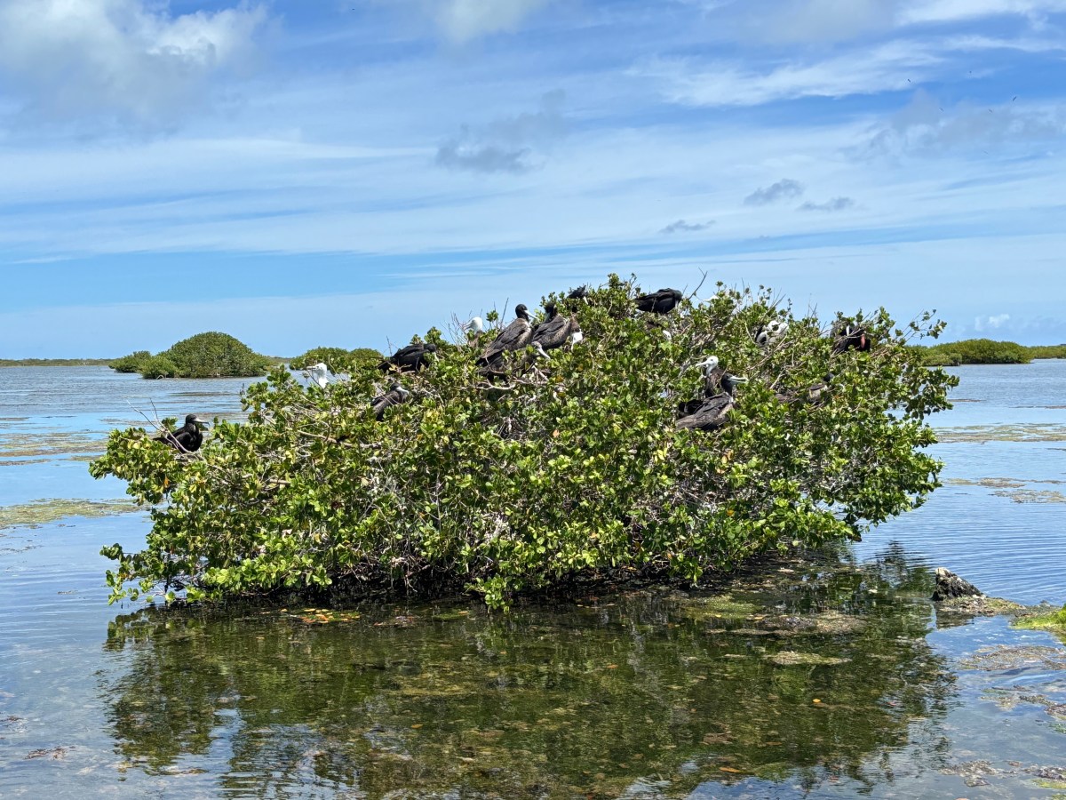
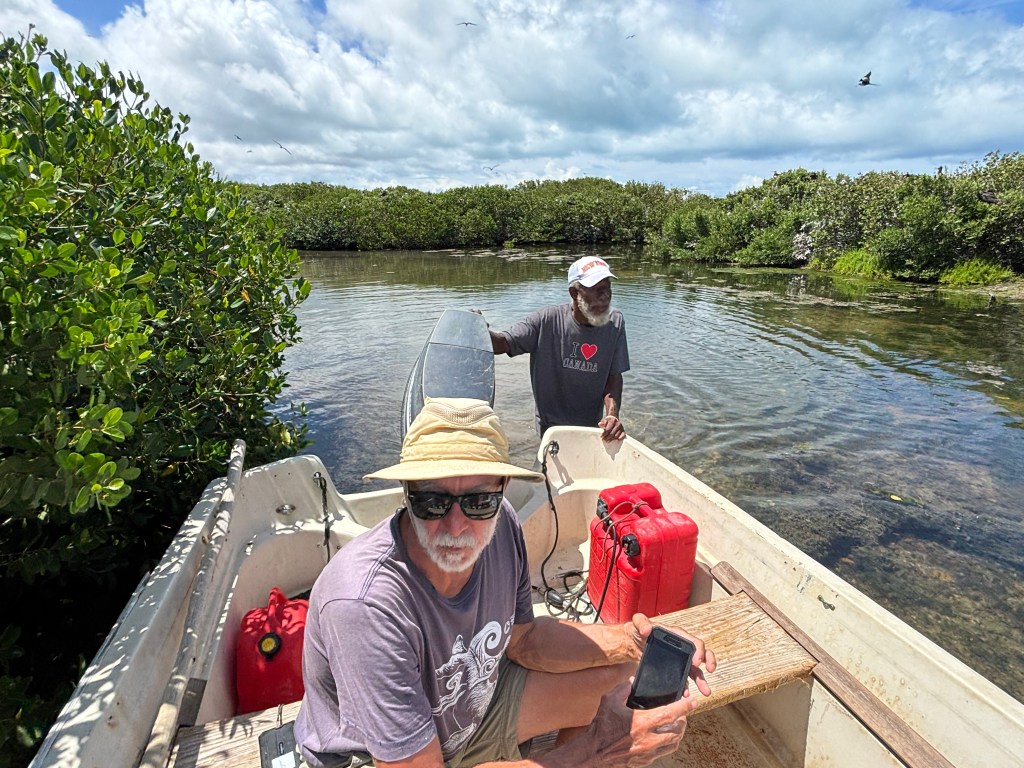
The morning after we arrived at Barbuda, we set out in dinghy at 8:30am to meet our guide for the Frigate Bird Sanctuary, a tour we had arranged before our arrival. We met George Jeffrey at the Codrington fishing dock, and the three of us, plus two other cruisers set off with George to see the birds. The first stop he made was well outside of the sanctuary where George told us a bit about the sand spit breaches I mentioned before, plus a little about the current troubles between Barbuda and Antigua. Then he took us to a small sandbar where he stopped again. That sandbar, devoid of all but a handful of tiny new growth mangroves, is the former site of the sanctuary. In 1960 (maybe 1961?) a hurricane hit Barbuda. Before its arrival, the Frigatebirds flew off to evade the storm. Upon their return, they found their mangroves gone, so they just flocked to another section of mangroves a little further north, and they’ve been there ever since. Then it was time to meet the birds.
What an amazing sight! In a stretch of mangroves approximately ¼ x ¾ of a mile, are thousands upon thousands of birds (I’ve seen estimates ranging from 12,000-20,000). The mangroves were heavily laden with (mostly female) adults and chicks of various ages. They were squawking, but it wasn’t as loud as I’d expected. George got out of the boat and slowly maneuvered us through the shallow waters, through upsidedown jellyfish-infested waters (they don’t sting) around the mangroves so we could observe them closely. We spent about a half hour just watching the birds. They are the national bird of Antigua & Barbuda and are on the Barbudan flag. George told us a bit about them, and I looked up more information later, all of which I share below (and include the links I used so you can read more if you like). There are pictures at the end of this post.
Frigatebirds are agile aerialists, that can fly for days on end, but they don’t go into the water. Their feathers, in fact, are not waterproof; they would be unable to lift themselves back out of the water. They feed on small fish (locally, flying fish are a favorite) which they scoop from the water’s surface, or steal from other birds. Adults are about 3½ feet long (beak to tail) with a wingspan of about 7½ feet. They have a deeply forked tail. All adults have black feathers, but the females’ chests are white while the males sport a bright red throat pouch. That throat pouch is how they woo females during mating season, which generally runs from September-April (peaking in December), which explains why we saw chicks of varying ages. Once a female has chosen her mate, the two build a nest where the female deposits a single egg. Both parents share the work of incubating the egg, which lasts about 50 days, and then feeding the chick. The males take off after about three months. The chicks fledge at about five months. The female continues to feed the chick for another four months or so. The chicks are fuzzy white and grow into their black feathers over time, with their heads changing color last. We saw newer chicks of fluffy white with only a few small black feathers forming on their wings, and we also saw older chicks just waiting for their heads to go black. (Audubon)(Lonely Planet)(Wikipedia)
Codrington Lagoon, where this colony resides, became a National Park in 2004. One can only enter the sanctuary with a local guide. The National Park only charges $5 per person to enter the sanctuary. Our tour with George cost $60 for all five of us together, so $12 per person. If you’re ever in Barbuda, I highly recommend taking this tour. If you can’t get George, there are several other guides as well.
The day after our Frigatebird tour, May 1st, we hauled anchor late morning and moved Lady to a reef anchorage on the south side of Barbuda, settling in Gravenor Bay. We spent two nights there, and this morning we moved about a mile closer to Spanish point at the southeast end of the island. There is a lot of shallow patch reefs to explore in this area, and we’ve explored many of them over the past 3 days. These are not very healthy reefs, but they’re better than what we’ve seen in Antigua. They are certainly heavily storm damaged, as evidenced by the coral rubble, and they also suffer from what ails all the reefs we’ve snorkeled and dived on in the Caribbean- bleaching, disease, and overuse (by incautious tourists). Unlike our experiences in Antigua, however, there is more sign of recovery here. We did not see any sponges, but there were many corals. A large number of them were sea rods, but there was quite a variety of other corals as well, just in smaller numbers. There were the usual fish suspects, and we saw several southern stingrays and sea turtles, and Dave saw an eagle ray. It was nice to finally have some snorkeling worth doing, and it was encouraging to see the regrowth.
Either tomorrow or Monday we will head back to Antigua to do some snorkeling on the north side reefs. Then we may move south to Falmouth Harbor to do some snorkeling there and explore the island’s interior by car before Ian returns home.
Until next time, stay safe and take care of each other!
Young chickChick gaining black wingsFledgling (note the white head)Adult femaleAdult maleMangroves full of FrigatesDave and our guide, George
From Marie Galante we popped back west to Îles des Saintes for some more snorkeling. We thought about diving, but the hookah is loud and there are a lot of people snorkeling where we wanted to dive, so we just snorkeled. The visibility is very good, so snorkeling is just fine. We spent two nights at Îlet à Cabrit, our favorite snorkel spot in Guadeloupe, and one night at Pan du Sucre. The snorkeling at the latter was good, but not as good as Îlet à Cabrit.
Hoping late March would provide an opportunity to head to Antigua, we decided to revisit the west coast of Guadeloupe, where we had spent six days back in late January/early February as we island hopped down to Dominica. On 3/22, we headed north to the anchorage about 1 nm south of Basse Terre, outside Marina de Rivière-Sens. Shortly after arriving, we dinghied into the marina and tied up to the wall so we could walk to Fort Delgrés. It was only a 20 minute walk, which turned out to be a good thing, because the fort was closed due to lack of water. Bummer! So back to the marina we went. It was hot, but at least there was a breeze, and most of the walk was along a pretty esplanade.
The next morning we traveled the 10+ nm north to the anchorage at Plage de la Malendure. We’d been here for two of those six days in early February and knew then we wanted to return. Just after our arrival and lunch, we snorkeled right off Lady on the north end of the bay, which we had not done last time. It was soon obvious why so many people from the little beach in the NE corner of this bay snorkel up and down this stretch; there is so much to see! It’s almost as good as Îlet à Cabrit. There’s lots of rock rubble for structure, covered in a fair amount of coral, including soft corals like sea fans, plus there were a ton of sea plumes (also a soft coral), many sponges, and lots of fish. The closer we got to the NW point, the more barrel sponges we saw. We snorkeled here two more times over the next few days.
Also while in this anchorage, we snorkeled the south and east sides of Pigeon island again, which we had done in early February. This visit, however, we also snorkeled the north and west sides. There is a lovely wall with lots of coral, sponges and fish. We thought it would be hookah-worthy for a dive, but weren’t sure it was worth setting up hookah for just one dive. There is also a spot with dive mooring balls just north of the NW point of the Bay, aptly named Pointe de la Malendure. We dinghied over to it and snorkeled there. Great reef! Now there were two spots we thought were hookah-worthy, and we knew there was another spot with mooring balls another mile north of this one. That afternoon, we set up hookah. We did dive the site just north of Pointe de la Malendure and the site one mile north of that, but we opted not to dive the wall at Pigeon Island. Pigeon Island is very busy with tour boats all day long, taking divers and snorkelers. Trying to navigate all that with the noisy hookah and two 60-foot hoses just seemed rude. The other two sites are much less busy. When we dove the nearer dive site, there was only one other small boat with divers, who we never saw and was gone by the time we resurfaced. At the more northerly site we had the reef to ourselves. Both were very good dives, with the nearer one being a little more diverse in its flora and fauna. We were glad we set up hookah.
About 4:00pm on 3/29, a National Park Service boat pulled up to tell us we were in a no-anchoring zone, along with 3 other boats. They kindly explained the markers that our charts simply labeled as “special purpose buoys” (not a helpful label), and gave us a QR code for their Marine Park app that shows where one can and cannot anchor in all their marine park locations. Very helpful, once I translated the French 🙄. So we and the three other boats moved a little further south in the bay. Sadly, we are no longer right next to the good snorkeling, but we had our six days, so we can’t complain. Had we recognized the official park boundaries, we wouldn’t have anchored there in the first place.
I’m writing this on April 1st (no joke) and we’re still anchored at Plage de la Malendure. Today is our 10th day here. It’s nice and all, but I am starting to get a bit bored. Yes, it is possible to be bored in paradise. We’d hoped for a weather window to head to Antigua, but that didn’t pan out. Then we thought maybe we’d go to the other marine park on the north side of the island between the “butterfly wings,” Grand Cul de Sac Marin, but that’s a lot of shallow reef navigating and there were supposed to be increasing winds and a big swell from a northerly direction, plus intermittent cloud cover which reduces the light needed to see the reef well. We don’t have local knowledge of the place, so it seemed unsafe to risk trying our hand up there. On top of that, it looks like we’re stuck on the west side of Guadeloupe at least through this coming Saturday.
Now what? We’re being indecisive. We know we don’t want to risk the marine park on the north. There’s not much sense going back to Les Saintes, because (a) it’s a bit far in the wrong direction for going to Antigua, and (b) the conditions the next several days won’t be great to head there anyway. Ditto for the south coast of Grand Terre. That leaves us three main anchorages on this side of the island. As long as we’re being indecisive, we may as well stay put and get some stuff done.
Over that past two days, I made cookies, weeded through a bunch of photos and did a small load of laundry. We went ashore to grab a few items at the nearby grocery store and discovered a reasonably priced laundromat with a washer and dryer large enough to wash two complete sets of queen sheets, plus a mattress cover in one load. On Lady that would be five loads and take two days. Score! After our grocery run, we got our bedding and headed back to the laundromat. We had lunch at the nearby boulangerie during the wash cycle. During the dry cycle, Dave explored the hardware/homegoods store next door while I caught up on email. Back at dinghy, we met two American men, cruisers just setting off for a bike ride. We chatted with them for a bit. It was our first socializing since our cousins left March 5th 😳. I miss socializing with other cruisers.
Now it’s April 1st and we still aren’t sure what we want to do with ourselves. We’re pretty certain we won’t stay in this anchorage the rest of the week. We’ve exhausted the activities we care about here. We had hoped to go to the zoo nearby, but there’s no good way to get there from here. It’s at least 1.5 hours walking each way. The bus schedule is limited and might give us at most an hour at the zoo, IF the buses are on time, which we’ve heard is an issue, and a taxi would double the cost of the excursion. Not sure the small zoo is worth it. This is an issue on this side of the island. The bus routes and schedules are limited and there are not many places accessible on foot from the anchorages. There are only two other anchorages on this side of the island that provide an opportunity to do anything ashore. If we head back south to the anchorage near Basse Terre, we may be able to rent a car and go see some sights. If we go north to Deshaies, we could rent an electric scooter, but I’m not sure how far we could range on that. At any rate, we’ll likely move someplace new tomorrow.
Mother Nature is having her April Fool’s joke today. She’s been sending us sunny moments punctuated by periods of rain. We’ve given up trying to sit in the cockpit or trying to keep the hatches fully open. We’re now inside with only our slider and the two small side hatches open. Good thing it’s not hot.
When this posts on April 5th, we’ll still be somewhere in Guadeloupe. Hopefully the post after that will be from Antigua, but we won’t hold our breath, and I suggest you don’t either.
Until next time, stay safe and take care of each other.
I’d rather be in my hammock reading than blogging. So today I’m going to give you some eye candy.
In early March, we saw a football-sized common octopus at Îlet à Cabrit, Les Saintes, Guadeloupe. I managed to catch a video of him swimming, crawling and then hiding.
Enjoy the show!
Until next time, stay safe and take care of each other.
Four of my cousins from Maine arrived late evening on 2/20. They had flown into Guadeloupe on the 19th and took the ferry the following afternoon from Point à Pitre to Roseau, Dominica. Dave took a taxi to drop off that Garmin display we had to return and to pick up the cousins at the ferry dock to get them back to Portsmouth and Prince Rupert Bay. They were onboard by 7:00pm and we turned right around for dinner ashore at the Purple Turtle restaurant. The service was SLOW, but the food was well worth the wait.
The following day was pretty low key. We took everyone ashore to get local currency and to pick up some fresh produce. We were planning to stay aboard the rest of the day until our friends on Sunny Girl showed up in the afternoon and asked who wanted to hike the Cabrits. Dave and I had already done it, but the cousins joined Kevin and Marsha. When they all returned, we had Kevin & Marsha stay for drinks and apps.
One tour Dave and I did not mind at all repeating was the Indian River tour, only this time, per the recommendation of Faustin Alexis, one of the PAYS guys, we did a 7:00AM tour. It turned into an 8:00AM tour because it rained at 7AM. Alexis picked us up as soon as the rain stopped and he gave us a lovely tour. We were early enough still that there were no cruise ship groups touring the river yet. Since the bush bar at the end of the tour route was closed in the morning, Alexis instead gave us a walking tour through the forest. It was worth getting up early to do the morning tour! We got back to Lady just before lunch and were deciding what to have when lunch came to us. A man and two women came up in a small boat selling chicken roti for $15 EC each (that’s $5.50 US). Easy, cheap and yummy! We spent a lazy afternoon aboard after that.
We had a 9:00AM tour with Alexis on Sunday 2/23. He took us first to the Syndicate Nature Trails and we walked one while he pointed out the flora and described its uses. His knowledge is vast. We then backtracked through Portsmouth to Calibishie where we had lunch before proceeding on to the Chocolate Factory. After that, Alexis took us back to Portsmouth via the northernmost road that passes through the old volcano crater and past the cold sulfur springs, complete with sulfur smell. Along the way, Alexis described his island to us. Born and raised here, he’s seen a lot of changes during his lifetime, most of the recent ones not necessarily good changes, especially since their economy has been depressed since the 1980s, and it worsened after Maria hit in 2017 and the 3000+ student medical school left the island for Barbados. We were back on Lady by 5:30pm after a fabulous, but long and tiring day. Lunch had been late and large, so we had a snack-y dinner and were all in bed by 9:00PM.
We were boat bound all day on the 24th because it rained off and on all day. The weather wasn’t much better on the 25th, but we had to go ashore, despite the rain, to do some final errands and clear out of the country so we could head to Guadeloupe. We were drenched! The rain mostly stopped by the time we returned to Lady and we dropped the mooring and set off for Les Saintes. The first part of the crossing was a bit bumpy until we cleared the northern tip of Dominica and Dave could alter our course to put the seas behind us. We made good time to Les Saintes, averaging 6.5 kts, and we were even lucky enough to get the last mooring ball in the anchorage at Bourg de Saintes at the island of Terre de Haut.
It was not raining in Les Saintes, and their mountains were not under clouds! (It rained to some degree every day we were in Dominica, for three weeks.) We spent our first full day walking about town, getting a mid-morning pastry treat and lunch later. In the afternoon, we snorkeled a wrecked ferry in the anchorage, close enough that we could swim to it right from Lady. The following day we returned ashore to hike up to Fort Napoleon. It was a hot uphill walk, but well worth it. The grounds are a lovely, well-maintained garden and the fort houses and excellent museum. The placards are all in French, but I got the gist of most of it. The walk back to town was faster and less sweaty, since gravity was in our favor, and we found delicious sandwiches before returning to Lady.
The last three days of our time in Les Saintes were spent on a mooring at the Îlet à Cabrit, 1nm west of Terre de Haut. This is a quiet, uninhabited island, though several day trippers showed up by small boat on the weekend. We explored the ruins of Fort Lorraine and of a hotel that never amounted to much, but mostly we snorkeled. The west end of the island has particularly good snorkeling, despite the sad state of reefs in general. There was an extensive grass bed, plus rubble and coral, many sponges and quite a variety of fish. Richard & Sharon even saw an octopus! The rest of us were jealous. Still, Dave and I saw several fish we’d never seen before, including a coney, a chain moray eel, a sharptail eel and a goldspotted eel.
We spent the final two days with our cousins up in the anchorage at Îlet de Gosier on the south coast of Grand Terre (the right butterfly wing of Guadeloupe), about 3 miles east of Point à Pitre. The anchorage is off a little island named for the nearby mainland town of Le Gosier, just a short dinghy ride from the anchorage. Îlet du Gosier is a park that vacationers, mostly French, and locals frequent. A small ferry runs continuously, during daylight hours, between the island and the town dock in Le Gosier. We did dinghy to the little island to explore it and the numerous little beaches around it. Late afternoon we went ashore to walk about town and to have dinner.
The following day we walked over an hour to the marina near Point à Pitre to decide if we would go there the next morning to drop off the cousins to go to the airport. It turned out to be too risky, not knowing if a mooring ball would be open or where we might anchor. When we walked out of the marina office, however, Bob talked to a cab driver who was dropping off a fare, and she spoke English! So he arranged for her to pick us all up at 1:30 PM at the aquarium (our next stop) and to also pick them up in Le Gosier near the dock the next morning. Win! So we backtracked to the aquarium and enjoyed about 90 minutes there. It’s small, but well curated, emphasizing local fish and their environs. The aquarium has the only sea turtle rescue in the eastern Caribbean. We grabbed drinks at the bar/restaurant outside the aquarium while we waited for the cab driver. Once we were back in Le Gosier, we sought out a late lunch. It was so late, in fact, that we opted to pick up baguettes, cheese and hard meats for an appetizer-like dinner later on Lady.
The morning of March 5th dawned bright and sunny. We had breakfast together, then the cousins started packing up to return home and otherwise soak in the warm atmosphere before they had to meet the taxi at noon. We joined them in the taxi and ultimately bid them adieu in the parking lot of a mall, where they graciously had us dropped off so we could sort out more data, since the data on our local SIM had been used up.
And this is where I shall leave you for now. I will tell you that I am writing this on March 22nd and Dave & I are still in Guadeloupe, eyeing a potential weather window late next week to move on to Antigua. Next time I will tell you more about our time in Guadeloupe. Until then, stay safe and take care of each other!
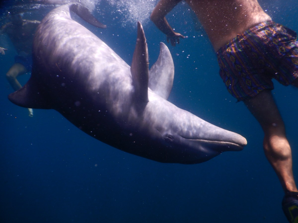
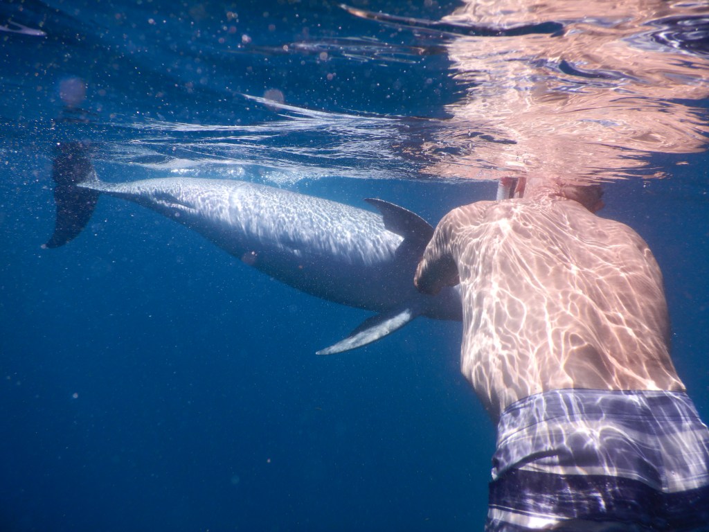
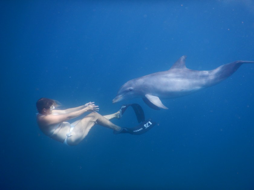
A couple of posts back I promised to tell you more about Dave and I swimming with a wild dolphin. I’m finally making good on that promise.
We were in Prince Rupert Bay, Dominica. One day before the Salty Dawg Rendezvous even started, Dave noticed a fin in the water a fair distance behind our boat, then he noticed a dinghy hanging out near the fin, and two swimmers in the water. Using our binoculars, we realized there was a dolphin playing with the two swimmers. This went on for about 30 minutes before the dolphin disappeared and the swimmers returned to their boat. We later learned from one of the PAYS guys that there was a dolphin that had been frequenting the bay for the past two years, frequently playing with swimmers.
The day after my cousins arrived, one of them noted a dolphin not far from our boat. Dave got in the water, but the dolphin disappeared, so Dave came back. Then we saw the dolphin reappear with a group of swimmers off to our starboard. This time we both got in the water and swam over to join the group.
It was amazing! The dolphin swam from swimmer to swimmer for about 20 minutes, sometimes just cruising by, sometimes pausing for a moment. It appeared to enjoy belly rubs, as it would often swim up and turn its belly toward a person. Dave got a brief ride holding its dorsal fin once. We both got to run our hands along its side a few times. It felt almost like cool, hard rubber. Despite its close passes by the humans, it never hit anyone with tail or flipper; it has an amazing sense of its surroundings. When it got tired of the play, it simply swam away.
Best wildlife encounter ever!
I did remember to grab my underwater camera before jumping in, but we were more focused on interacting with the dolphin than capturing photos and video, but we got a few good shots. Enjoy the stills and the video of the first drive by the dolphin gave me.
Until next time, stay safe and take care of each other!
Lisa pats the dolphinDave pats the dolphin
Dave should enter this in a photo contest! Wish we knew who the woman is so we could send this to her.