Luperón to Puerto Rico

We interrupt the chronology of our trip to notify you that we made it to Puerto Rico. Sound the horns! Ring the bells! Huzzah! 

Here’s the story…

In case you missed it, we arrived in Luperón on March 13th. We were there for 25 days waiting for a weather window to continue east. The first potential weather window presented itself for March 27th, but we didn’t take it for various reasons I may describe at another time; it turned out to be a good decision. We had our eyes on a potential second window for the following week, but it didn’t pan out. Our chance finally arrived Easter weekend and it was going to be a good one. We would get our despacho (departure papers) on Saturday and head out either that night or the wee hours of Sunday morning to start our direct shot to Puerto Rico. Silly us! 

Easter is a BIG deal in the DR. We didn’t understand how big until we learned Thursday morning that Customs & Ports was closing at noon that day and wouldn’t reopen until Monday morning. In the DR, one checks out with Customs & Ports first, then goes to the Armada for the official despacho. With Customs & Ports closing Thursday, there would be no despachos until Monday morning. The other thing you need to know about DR despachos is that the day you get it is the day you leave port. Yikes! The conditions would not be good to depart until late Saturday night, and there was no guarantee that the weather window would hold long enough if we waited until Monday. What to do? 

Several boats were in the same situation, so we created a WhatsApp group to discuss strategy. Four of us (Indigo Lady, Wild Horses, Caretta, and Bitty Rose) decided to get our despachos Thursday, leave the harbor anchorage and stage in the little Pinzon anchorage just outside the official harbor and hope the Armada ignored us for the holiday weekend. 

The Armarda did not ignore us. 

At 2pm on Friday, I got a call from a representative of the Armada. They wanted to know why the four of us were still there, and threatened to take our despachos if we didn’t leave right away. I begged a little time to confer with our buddy boats and said I’d call back to let them know of our decisions. After some texting amongst the group members, and a call to Chris Parker (the human weather router we use), we all decided to leave, but really wanted to wait until midnight once the seas and winds had settled. I called the Armada representative and explained that midnight was the safest time to leave and if we were forced to leave earlier, the Armada may have to come rescue a boat or two (perhaps a slight exaggeration). Irritated, he finally told me that if anyone was there in the morning he was taking our despachos, and he hung up. 

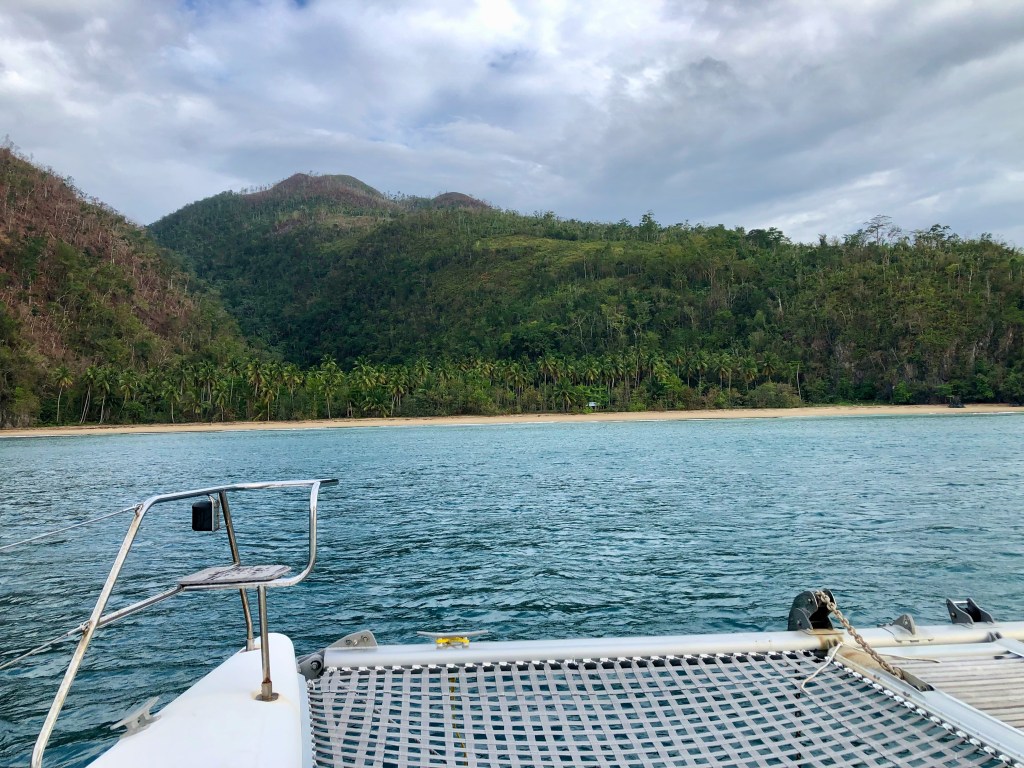
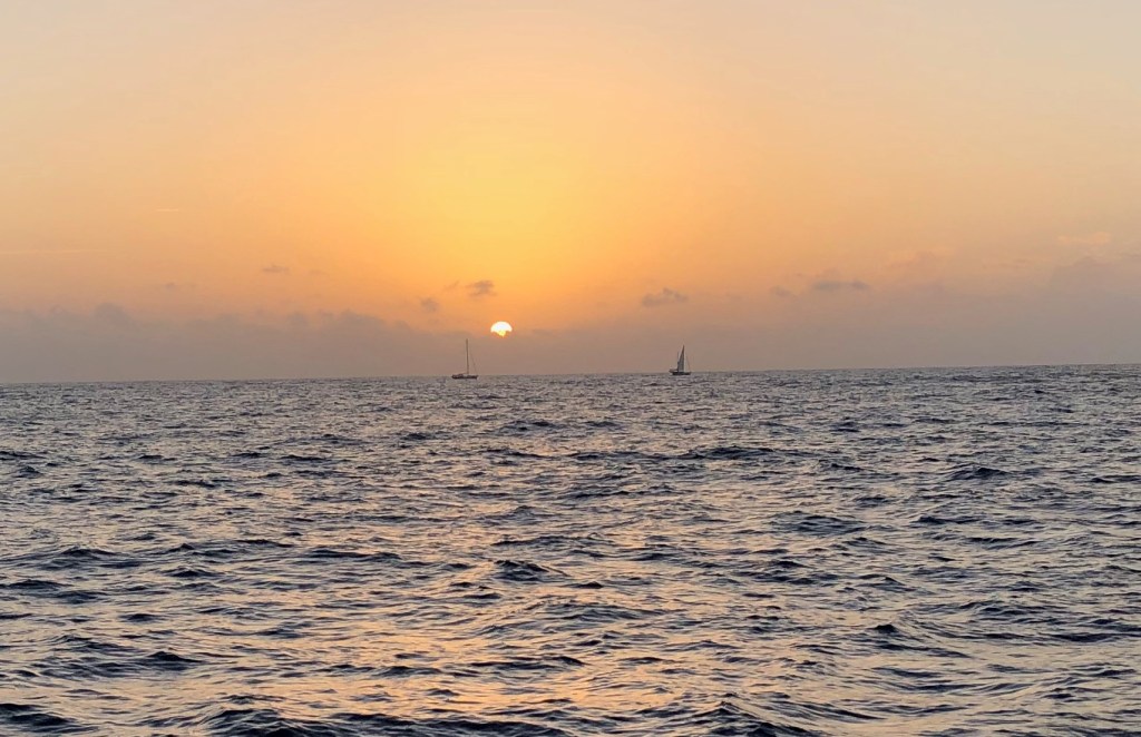
So…at 12am Saturday morning we all hauled anchor and had a very decent passage to Río San Juan, 52 nm east of Luperon. We dropped anchor for the day, when the winds & seas pick up, and rested until 12am Sunday morning when we all hauled anchor again and headed for Escondido another 55 nm east. It was a good passage and we brought up the rear, anchoring around 10am or so. We passed a quiet Easter Sunday in the shadow of some mighty fine mountains, with a little village barely visible just beyond a beach. Our next stop would be Puerto Rico. Bitty Rose left just after 5pm Easter night while the rest of us waited until 4am Monday morning. It was a quiet, calm cruise of about 15-20 nm around Cabo (Cape) Cabron and Cabo Samaná. As we were passing the mouth of Bahía Samaná (Samana Bay), Dave & I took a different route than the others, so at this point our stories diverge for about 24 hours.

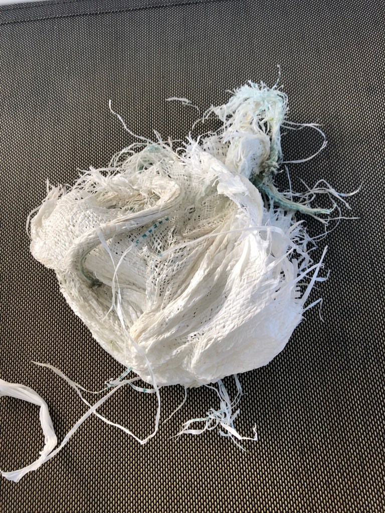
Our friends on Wild Horses and Caretta went north of what’s called the Hourglass Shoals. Dave and I opted to continue down along the DR east coast to near Punta Cana (Cana Point) before turning into the Mona Passage south of Hourglass Shoals. The first 7 hours from Escondido around the capes and across the mouth of Samaná Bay were wonderfully calm. Then, around 11am, the wind and seas started picking up a bit. Then they started picking up a lot. It was a very bumpy, wet ride for the next 3-4 hours as we hobby-horsed and took water over both bows. Good thing Dave installed and deployed the wind/rain shield or he would have been soaked! We slowed to 3 kts and started talking about bailing out at Punta Macao to wait until the seas subsided. The wind and seas started calming a bit, but we were still only making 3 kts. Hmmm… We’ve been in worse seas making better time, so Dave suspected that something wrapped one or both of our propellers. Now we had two reasons to stop at Punta Macao. We’d lost radio contact with our buddy boats not long after we learned they were experiencing the same bumpy conditions (too far away), but we picked up another sailboat that hailed us. We both decided to stop at Punta Macao and did, in fact, meet there. 

I started to get a little nervous because our despacho was for Samaná; it was not an international despacho to clear out of the country. We had read that most folks who stop in Punta Macao get a visit from the Armada, who would want to see our despacho and would ask why we had not stopped in Samaná. Why didn’t we get an international despacho? From what we had read, most boats that set out from Luperón end up stopping in Samaná anyway because the weather window doesn’t hold. If we had officially cleared out of the country with an international despacho, and then had to stop in Samaná, we would have had to pay to check back into DR. We wanted to avoid that, so we took a gamble. Turns out I worried needlessly. 

We set anchor at Punta Macao around 5:30pm and immediately started pulling out snorkel gear and tools for Dave to check our props. We had something wrapped around the shaft of our port prop, but starboard was clear. Dave had to launch the hookah so he didn’t have to keep coming up for air while he worked. I sat in the sugar scoop and handed him tools and took what he handed me. He removed the prop and was then able to remove the wrapped stuff quickly and reassemble the prop. Turns out it was not a fish net, as we had anticipated, but was one of those synthetic burlap type bags. While he cleaned gear, I warmed our dinner. We ate quickly and then hauled anchor, along with our new buddy boat. Maybe the Armada saw that we were making a repair and decided to hold off visiting until they knew whether or not we would leave. Maybe they were recovering from the busy holiday weekend and had no intention of visiting us at all. Regardless, they did not visit us and we did not need to defend our travel plans. Phew!

This is what wrapped our prop

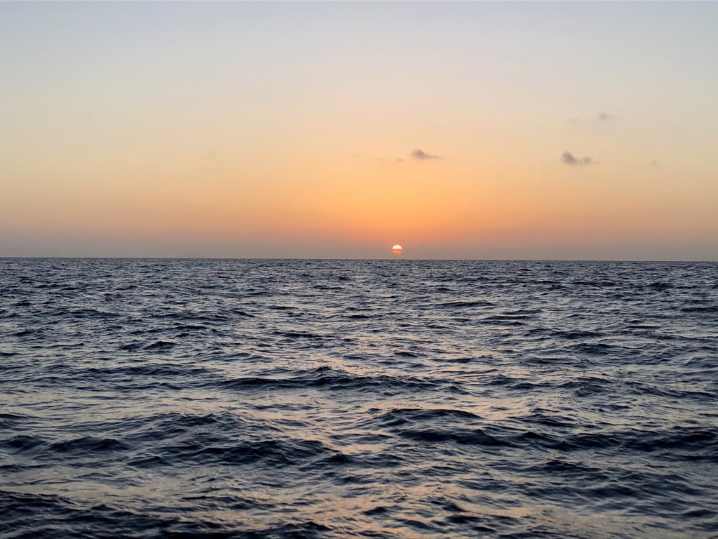
The seas had calmed and our passage continued smoothly but for a couple of hours during one of Dave’s wee hour watches when it got a bit bumpy again, but not as bad as the afternoon. It was nice having a buddy boat in sight and in radio communication, especially during the night watches. I saw sunrise over the Mona Passage in calm seas. We learned to stop the boat and clear our propellers of accumulated sargassum seaweed occasionally, by pulsing them in reverse, to keep up our speed. Seas were glassy for a bit, then a bit bumpy about 10 nm out from Puerto Real until we were close enough to be in the lee of the island. We arrived in port around 1:30pm. Wild Horses and Caretta had arrived about 8am, and Bitty rose the day before. Hail, hail, the gang’s all here!

Sunrise over the Mona Passage

Now we are at our second Caribbean island and one step closer to the Caribbean Sea. By the time you read this, we’ll actually be there, because as I type, we are en route to our first anchorage on the south coast of Puerto Rico, the northern border of the Caribbean sea. 

Next week I’ll probably wrap up our stay in Luperón and then after that, pick up with our Puerto Rico adventures. Until then, stay safe and take care of each other!

A Visit to Santo Domingo

Our friends on S/V Guajira had arrived in Luperón almost a week ahead of us. The gorgeous weather window that brought us to Luperón from TCI the following week was supposed to have brought then to Samaná on the east end of the Dominican Republic. A day prior to that, conditions had not been great and the Armada had to rescue a boat off the coast. They kept the port shut to outgoing traffic for two days, which stranded everyone who had been banking on using that beautiful weather window. At some point I really am going to have to write about weather windows and clearing in and out of island nations. The bottom line is that Guajira was still in Luperón when we arrived.

The morning after we arrived, Guajira invited us to join them on a Wednesday-Thursday road trip to Santo Domingo, the Capitol of DR, located on the south coast. Of course we would! So we booked a room at the same hotel. Juan picked us up in their dinghy the next morning, Wednesday, around 8:30am and we met Alison and their friend, Glyn, at the Las Velas marina where they had brought the rental car. Off we went! 

The first part of the 3-4 hour drive was through the beautiful countryside and mountains. We made good time to Santo Domingo, but it took us about 20 minutes to find parking, all on street. Turned out to be just around the corner from the hotel, so score on that one. We stayed at the lovely Mosquito Boutique Hotel in the historic Colonial Zone of the city. It was too early to check in, so we left our bags in the hotel’s laundry room and set out in search of lunch. We ended up at Buche Perico about a block and a half away and had an amazing lunch. After lunch, we went for a walk about town looking to learn a little of the history and tour some museums and ruins (often the same thing). We were thwarted at a couple of places, including the Fort, because they were closed in preparation for some big upcoming event. Alas! We did, however, get to tour the palatial home of Christopher Columbus’s eldest son. We stumbled upon a free Taino artisans’ exhibition. The Taino were the indigenous peoples of Hispaniola when the Spanish arrived and enslaved them, almost wiping out their entire population. I wish I knew more Spanish so I could have picked up more of their history. There was a man making pots, another sculpting figurines of their various gods from clay, and another grinding chocolate (which we could taste). There were women displaying and selling their knit and woven goods. There was food to sample. It was a great find!

Late afternoon we returned to the hotel to finally check in, shower and rest for a bit before meeting down in the hotel bar for drinks before dinner. Dinner was at Jalao, right next door to where we’d had lunch along a little park. I had a traditional Dominican dish called mofongo, which I’d been wanting to try. It is a mashed plantain base with spices served with spiced pork and beef, in my case. Delicious! Now I want to learn to make it. It was a beautiful evening sitting outside eating. It reminded me of eating late on Piazza Navona in Rome.  We all slept well that night.

We met for breakfast in the hotel atrium the next morning. The atrium was gorgeous! It was open to the sky and surrounded by the walls of the rooms (door sides opening toward atrium), laundry room, bar, entryway and reception, and the building next door. It was filled with potted plants, a fountain, a tree, and vines dangling down from the railings of the walkways along the rooms of the second and third floors. Breakfast was included in the room price and consisted of eggs cooked to order, fresh fruit juice of choice, toast, and fresh fruit and coffee or tea. Since checkout wasn’t until noon, we had time after breakfast to tour the nearby Cathedral of Santa María la Menor. It is the first and oldest Catholic church in the Americas, constructed between 1504 and 1550. It is a lovely and still functioning Gothic-style cathedral belonging to the Archdiocese of Santo Domingo. From the cathedral, we returned to the hotel to check out, put our bags in the car, and trotted across the street to a ruin we had seen upon our arrival. It was the remains of the first hospital in the Americas, dating from 1503. The current ruins are unlikely to have much of that original hospital left as the structures there were rebuilt and repurposed several times. We gave it a quick view, then hopped back in the car.

We headed to the outskirts of the city in search of the national park called Los Tres Ojos (the Three Eyes). What a gem in the city! It’s a cave mostly open to the sky with three lakes below ground level. It is believed to have formed over 10,000 years ago, at the end of the ice age, when the ceiling collapsed. They’ve done a great job constructing paths and landscaping to guide visitors to the lakes. One lake is reached by a small, rectangular wooden ferry that seats about 10 people and is pulled across by a “driver” on a pulley & rope system. It was a lovely bit of nature in the city.

It was then time to head back to Luperón. The trip back took a little longer because we missed a U-turn on their completely divided highway that would have taken us in the direction we needed to go. There are only certain points along the highway around the Santo Domingo area that allow one to reverse direction. We ended up having to go back through the city rather than around it, and there was quite a bit of traffic. Eventually we were on the open road. When we got hungry, we stopped at one of the dozens of roadside comedores. These are small roadside, family-run cafes, open to the road, with small kitchens, limited menus, and all local food. It was good and inexpensive, but they had the music up way too loud. We made another quick stop at a combination liquor/grocery store for some rum and were back in Luperón by 6pm. We spent Friday onboard recovering from our whirlwind exploration.

Here’s a slide show of some pictures from our Santo Domingo trip. I took way too many and had to spend hours weeding them out. When will I learn? Enjoy the pictures. Until next time, stay safe and take care of each other!

Turks & Caicos to Dominican Republic

This was our first overnight passage with just Dave & I onboard, which meant standing 3-hour watches with little sleep in between. I needed it to be an easy passage, so we used Chris Parker of the Marine Weather Center to help us find the right weather window and route. It was a straightforward trip, so he suggested we depart late morning on March 12th so we would arrive by noon on the 13th in Luperón, and he gave us a waypoint to head for that would keep us out of the worst of the westward flowing current as long as possible before heading more southerly for Luperón. It was a beautiful, calm passage! 

We hauled anchor at 11:00 AM on the 12th and cruised on solar and battery alone until 4:00 PM. Then we turned on the port generator and cross-ship cable and ran both motors off the one generator the rest of the way. Most of the time our motors were set at 2.8 KW each and we made 4.5-5 knots. We started 3-hour watch rotations at noon, with the off person trying to catch a nap. The moon just started to rise during the last 15 minutes of my 9pm-12am watch. When Dave came up to relieve me, we both went forward to sit in the tramp at the bow for a few minutes to admire the stars. We could even see the Milky Way! During Dave’s 12-3 AM watch we hit the westward flowing Antilles current which slowed our eastward progress a little, so Dave bumped up the power to 4 KW each to maintain our speed at 4.5 kts. On my 3-6 AM watch I had to slow us down again so we would be approaching Luperón Bay after sunrise allowing us to see the fish net floats we’d heard about. During that shift, the half moon and stars were casting enough light that I could see the horizon in all directions. It was during this watch that I also started seeing boats again, both on the AIS  and radar, and visually by their lights. Sometime around 5am, two cruise ships crossed our stern about 1.5 miles off heading to Puerta Plata a little to the east of Luperón. We entered Luperón Bay around 8:00am on the 13th.

Friends who had arrived a week ahead of us had given us some information about the check-in process and mooring balls. I had also been asking questions in a Dominican Republic FB group run by the Seven Seas Cruising Association station host, who happens to be based in Luperón Bay. She and her husband told us to hail them when we arrived, which we did, and they got the ball rolling or the Armada to come out to our boat to start the paperwork, and for the local mooring ball owner, Papo, to escort us to a good spot to anchor until he had an open mooring. It was nice to have all that facilitated for us. The Armada showed up within the hour, with an English-speaking interpreter, and gave us the paper allowing us to be here. We gave them fresh-baked (on the way in) chocolate banana bread and soda. We later went ashore to complete the check-in process by visiting Immigration ($75 for 30 days), Customs & Ports ($30 port fee) and Agriculture ($10 and a promise we had no forbidden produce onboard). We returned to Indigo Lady, took down the Q-flag and ran up the DR flag (which we had to buy from Papo because did not have one- ack!). Papo wouldn’t have a mooring for us until the next day, so we moved to a better anchoring location out of the channel. Our friends on Guajira invited us over for drinks and snacks around 6pm. So we rested for the afternoon and joined them for a couple of hours of low-key conversation and camaraderie. Dave and I returned to Lady for a late, light dinner and bed. We slept like rocks until 8am the next morning!

After three years, we finally made it to our first Caribbean country! Technically, we’re still in North Atlantic waters, because the north border of the Caribbean Sea is the south coasts of Hispaniola and Puerto Rico. (For those geographically challenged, Hispaniola is the island containing Haiti and The Dominican Republic.) We arrived March 13th and we’re still here as I type this today, April 1st (no fooling) waiting for a good weather window to continue east to Puerto Rico. That wait will continue at least until late next week. Our fingers are crossed that that potential weather window actually materializes. This is the longest we’ve been stuck waiting for the right conditions to continue our journey, and perhaps I will write about that another time. As I’ve said before, there are worse places to be stuck, and we are enjoying ourselves with exploring and meeting new people while we wait.

This is enough for one entry. I’m going to continue to write while I’m in the mood, but I’ll parse that out over a couple of posts. Until then, stay safe, and take care of each other!

Turks & Caicos

Settle in, folks. I’m cramming our entire two weeks in Turks & Caicos into a single post. Although the Turks & Caicos Islands (TCI) cover only 75 miles to the Bahamas 500+ miles, it is very difficult to get around, so we did very little of interest ashore, and there wasn’t much to be done in the water, either. So one post is all it’s worth. I’ll give a little description of TCI, then get into what we did. I’ve labeled the two sections so you can skip one or the other if you like.

Description

The Turks & Caicos Islands are geologically similar to the Bahamas- coral limestone outcroppings, mangroves and turquoise waters. From east to west, the shallow Caicos Bank is bordered by the larger islands to the north of Providenciales, then North, Middle and East Caicos, and by reef to the south. Throw in West Caicos on the western edge and South Caicos on the eastern edge. From South Caicos, travel east across the deep water Turks Island Passage to reach Grand Turk Island, with little Salt Cay and even tinier Big Sand Cay to the south and a little east. TCI comprises 40 islands and cays, 11 of which are inhabited. The total population is around 32,000, with 90% of those residing in the Caicos group of islands, over 23,000 in Providenciales alone. The north side of the northern islands is outlined by reef as well. One can arrive by boat either on the north side or south side of Providenciales, but once arrived, there’s no way to reach the opposite shore without going back out and around the western edge of Providenciales, unless you are a very shallow-draft boat, like 2’ or less. In the past, TCI was known for the production of salt and sisal, and for sponge farming. The remaining local industries include some fishing, as well as some locally grown produce from more fertile North Caicos. Otherwise, TCI relies very heavily on tourism these days, with cruise ships going to Grand Turk. 

The Taino and Lucayan Indian peoples populated the islands from the 500s to 800s. Once the Spanish arrived in 1492, they sold the Tainos and Lucayans into slavery on Hispaniola, which both depopulated the islands and resulted in the near extinction of both peoples. The Spanish, French and British dominated the islands in the 16th-18th centuries, bringing in African slaves, but there were no permanent settlements until the Loyalists fled America during the Revolution, some landing in the TCIs. Pirates also used the area as a hangout. The islands were annexed by Britain as part of the Bahamas in 1799. In 1841, 7 years after Britain abolished slavery, an illegal slave ship, the Trouvedore, sank, and the surviving 192 African slaves came ashore to freedom and settled. Their descendants comprise about 90% of the “belonger” population today (ie- not more recent transplants). In 1973, Bahamas became independent from Britain, but TCI remains to this day a British Overseas Territory. They have a governor appointed by the reigning British monarch, and since their 2006 Constitution, a Premier who is the political leader and head of government. You know, the typical colonial empire story. (Thanks to our 2018 Explorer Chartbook of the Far Bahamas with Turks & Caicos for providing all this information. It saved me from using up our data for the research.) 

Our Explorations

The alarm went off at 4:45 AM on Sunday, February 26th. We started the coffee, did a quick check of the marine weather, then hauled anchor at 5:00 AM to start our passage to Turks & Caicos (TCI- for Turks & Caicos Islands). We bid farewell to the Bahamas after three years, and watched the sun rise over the Atlantic. Guajira departed an hour after us, knowing they would travel faster than we would and eventually pass us, which they did sometime late morning. We had both had terrible crossings to Mayaguana, where we met each other, and were looking forward to a beautiful, calm, day passage to TCI. We were not disappointed! We had gentle swells that only got gentler the closer we got closer to TCI. At just past 7:00 AM, a fish hit one of our lines and shortly thereafter, Dave landed a good size Mahi that ended up netting us 5 lbs of fillets. Woo hoo! Guajira was graced with a Mahi as well, shortly after us. We were anchored in Sapodilla Bay on the south side of Providenciales by 2:00 PM, Guajira having anchored about an hour before us, at which point they radioed us with information about depths and location. I went up to the roof to remove the Bahamian flag and run up the Q-flag. We decided to clear into the country the following day, so we stayed aboard resting for the remainder of Sunday. (In brief, for those unfamiliar, you are not allowed to step off your boat until you have officially cleared in with Customs & Immigration. At some point I’ll post about the clearing in and out process for cruisers.)

We radioed Guajira Monday morning, and since they had a working phone, they made the arrangements for both them and us to get slips at South Side Marina where Customs & Immigration would meet us for check in. This time we got to return the reconnaissance favor to Guajira, who draws 6’ of water to our 4’. We headed into the marina on half tide rising and reported depths back to them, seeing 5.7’ at the shallowest before high. So they timed their entry for about an hour after us and had no problem getting in. It’s good to have a buddy boat! We had lunch aboard while we waited to clear in. The officials arrived about 1:00 PM and Dave was back on board by 2:00 PM. With the freedom to finally go ashore, Mom & I washed sheets and towels in the marina laundry while Dad & Dave remade the beds. We all took luxurious showers ashore! That night, the four of us, plus Alison and Juan from Guajira, attended a potluck hosted at the marina every Monday night. We met some interesting people, including the past and present owners of the marina. We even saw a Space-X launch!

We spent the next two days exploring Providenciales, the most populated island of the TCI, by rental car. There is practically nothing one can get to by foot from any of the marinas or beach landings, so exploring requires a rental car. 

On Tuesday, we checked out the shopping in the Grace Bay area, which had mostly kitsch or high end stuff that has nothing to do with the TCI. We had lunch at the Mango Reef restaurant at Turtle Cove Marina on the north side of the island, then went to snorkel at Smith’s Reef. It was a challenging entry from the beach, so my folks just paddled around near shore a bit. Dave and I swam the short distance to the reef only to be disappointed by mostly dead coral, poor visibility and a few fish and one small sea turtle. People on one of the TCI Facebook groups raved about the snorkeling here, but I’m not sure what their frame of reference was. It was not the same as ours, however. We had been planning to then go snorkel the “Coral Gardens” off Grace Bay beach, but decided it would likely be the same and so did not do so. We had dinner at Bob’s Restaurant at the marina. Alison and Juan had picked up their friend, Glynn, who is crewing with them to Puerto Rico, and they sat near us at dinner so we could chat while we waited for food.

The next day we headed for Northeast Point National Park, the furthest point NE on Providenciales. The paved road became a very dusty but graded, hard-packed dirt road, then a single lane dirt road, ending in a “parking area,” which is really just a couple of bump offs from the little road before it becomes beach sand. From there it was a very short walk to the beach on the Atlantic. We walked northeast toward the point, pretty close to a mile away. My folks stopped earlier, but Dave & I went all the way and took the obligatory pictures at the aid to navigation light. We were treated to gorgeous views! There is an awful lot of resort development going on in an area that is supposed to be a National Park. Makes one wonder whose palms are being greased. After our beach hike, we drove the coastal road back toward town looking for Da Conch Bar restaurant that we’d heard was very good. We found it. It’s on the beach and is entirely outdoor seating under the shade of palm trees. The seating is split between being up on platforms and down on the beach in the sand. Yummy food, too. 

We left the marina late Thursday late morning. First, we had coffee with another couple we’d met, Brent and Debora on M/V Change of Pace; they are also heading to Puerto Rico via Dominican Republic. We bid farewell to both Change of Pace and Guajira and headed back to Sapodilla Bay for the night before moving on to West Caicos the following day. That island is on the western entrance to the Caicos Bank. We’d passed it transiting to TCI from Bahamas. We anchored in good sand among the well-dispersed coral heads on the north side of the island. This area is a National Park. There is a lovely, long sand beach and scattered corals. There’s also a would be marina around the north point on the west side of the island, and development of what appears to be a resort, in a National Park. Go figure. We spent three nights here exploring our surroundings in this peaceful anchorage. The coral was, as usual, mostly dead, but there were spots with fish, and one patch of coral not far from our boat had some live coral as well. It was a relaxing few days after our city excursions. We met only one other boat  that stopped to say hello; they were also originally from NH! Monday morning, the 6th, we headed back to Providenciales, this time anchoring a little east of Sapodilla Bay, behind Bay Cay. It made for a short cruise to South Bank Marina the next morning for my folk’s final day and night onboard.

We arrived at South Bank Marina about 9:00 AM on the 7th, filled our diesel tank with their clean, filtered fuel, and then took up our spot on the dock for the night. After that, it was all about chores. Mom & Dad worked on packing while Dave & I met the rental car guy in the parking lot and then worked on getting our empty propane tank refilled and on reprovisioning for the next 8 weeks. We stopped at the local brewery so Dave could by a couple of cases of their beer (in cans- yay!), so we just had to sit and enjoy a draft beer. We shared a stout, a type I actually enjoy.  We finished our errands, returned to the marina, showered, and took my folks back to Bob’s Restaurant at South Side Marina for a farewell/upcoming anniversary dinner. We played a final round of Michigan Rummy back on Lady before bed. 

We got my folks to the airport by 9:00 AM the following morning, Wednesday the 8th. After bidding them farewell, we did a few more errands before we had to return the car for noon. The most important errand was to replace the connection for the propane tank that Dad had noticed was leaking when he put the newly refilled tank in place. Thank goodness he noticed! We managed to find what we needed after several stops and Dave replaced the part back on Lady before we pulled out of the marina mid-afternoon. We anchored off Cooper Jack Point, a bit east of our last anchorage, and there we stayed through Friday, March 10. During that time we did a bunch of boat chores and passage preparation for our upcoming, overnight passage to Dominican Republic. Dave cleaned, sorted and stored our snorkeling gear, spent a couple of hours cleaning our hulls, washed down our decks and made water. I did laundry and prepared various food stuffs for the passage (and beyond), vacuumed and washed the floors, and created our exit ticket for TCI and entrance tickets for DR online. Alison and Juan called us at one point with a bunch of helpful information about Luperón, where they had safely arrived Wednesday morning, the day my folks flew home. Sadly, they would not be there when we arrived, as the weather window that would bring us to Luperón would send them to Samaná.

Dave dinghied ashore to clear us out of TCI Friday afternoon, and at sun-up on Saturday we were underway to Big Ambergris Cay, our final stop in TCI before our passage to Luperón. It was a very calm passage and we were anchored by 2:30 PM. That was enough time to enjoy a snorkel at two nearby coral heads before drinks, dinner, a movie and bed. 

Sunday morning dawned bright and calm, so I did yoga on the tramp walkway. We had a hearty breakfast and tended to a couple of final tasks. We’d planned a 12:00 PM departure, but the sun was so good, we opted to leave at 11:00 AM and cruise on solar and battery as long as we could. So we hauled anchor and set off for Luperón. You will have to wait for next weekend’s post to hear about that trip. 

Until then, stay safe and take care of each other!

Mayaguana

Our overnight passage from Rum Cay to Mayaguana started out very nicely at 7:30 am on Tuesday morning, February 21st. We enjoyed lovely, calm conditions right up until 10:30 pm. Then it started getting a little bumpy. Since it was an overnight passage, Dave, Dad and I stood 3-hour watches starting at noon on Tuesday. I was third in the rotation, so my first watch was 6-9pm, then Dave took over from me. Around 10:30pm I realized it was getting bumpy and noisy, so I laid there not sleeping. When Dave came down at midnight after Dad relieved him, I went to lay up in the salon and still couldn’t sleep. It was getting bumpier. At one point during Dad’s watch, all three of us were up trying to decide what to do to ease the ride a bit. We changed course to go west and south of the Plana Cays, rather than north of them. This bought us a few hours of calmer conditions. Sadly, at about 3:30 am, during my second watch, we had to turn back into them. Then the starboard generator started acting up like it had back in January. I woke up Dave and we watched it for a while, but ultimately had to shut it down and turn on the cross-ship cable so the port generator could run both motors. That ‘failure’ of part of our system invoked that residual fear I have from our stranding in 2019. I realized, however, that it wasn’t as extreme this time. The fear was there a little, but mostly I was pissed off that conditions were, once again, not as forecast. The sunrise was beautiful, but seas got no better, in fact they got a little worse, and there was a period of time when we saw too many 8-10’ waves. It felt like we were in a washing machine. We did some tacking above and below our course line to keep the worst of the waves just off our bow. Eventually we were close enough to Mayaguana and its extensive reef to benefit from some slightly diminished seas during the final 1-2 hours of the trip. We were anchored by just after 3:00 pm on Wednesday the 22nd. The tacking turned our 128 nm trip into a 140 nm trip, but we still made good time despite that and beating into the seas for 16 hours. We averaged 4.5 knots, and though uncomfortable, were never in danger. Dave made fruity rum drinks and then pizza, good comfort food after a lousy passage. We started a movie, but were all nodding off, so we went to bed and were sound asleep by 9:00 pm. I slept straight through the night for nine hours. 

After a good night’s sleep, I was coherent enough to take note of our surroundings. We were anchored in Abraham’s Bay, named for the settlement on its east end. The bay is huge, running five miles from east to west and almost two miles north to south. Like the anchorage at Rum Cay, this one is really just open water bordered by land on the north and east sides and an extensive reef system on the south and west sides, more extensive than the one at Rum. Also like at Rum, the reef breaks the worst of the waves, better at low than high tide, but with the seas up, it was a rolly anchorage, this time with occasional light slapping without the big vibrations. We read that the population on the island is around 200, divided between three settlements, but with the preponderance of people in Abraham’s Bay Settlement.

About mid-morning the next day (Thursday), the only other boat in the anchorage, Guajira, hailed us on the radio to say hello. They had arrived earlier the day before in the morning after having been beaten up on their passage from Crooked Island, so we compared notes. We also compared travel plans and realized we were both en route to Puerto Rico via Turks & Caicos, then Dominican Republic. We planned to get together for drinks at some point and discuss the possibility of traveling together, at least to TCI (Turks & Caicos Islands). The rest of the day was a light chore and recuperation day. After breakfast, Dave & Dad got the starboard generator running again. I guess it just needed a nap. Then Dave made water and went out to give our gunnels a freshwater rinse after our very salty passage. I did laundry and then relaxed the rest of the day.

After checking the forecast predictions on Friday, we and Guajira determined that Sunday would be a perfect day to cross to TCI. So I spent the morning clearing us out of the Bahamas and starting the clearing in process for TCI, both done online. In the afternoon, Juan and Alison from Guajira came over for drinks and snacks and we talked nonstop for several hours. They are kindred spirits! We planned to cross to TCI together on Sunday. Juan also allayed our concerns about transiting the north coast of Dominican Republic, when the time comes, so now we feel like we have more options than making the single, 120+ nm jump from Luperon to Samana against wind and sea. We knew short hops were possible but had had some concerns about safety in the isolated bays.

Saturday morning we moved Lady to the east end of the bay so we could dinghy ashore to explore the town. On our walk to town from Government dock, a nice lady stopped in her vehicle to greet us. She was the former principal of the island high school- a fellow educator! Then a nice officer hailed us in town to see if we needed anything. We were looking for lunch, so she called a friend of hers to see if she could make us lunch (from her house, not a restaurant). She could make us either burgers or chicken with fries. We ordered the burgers and walked about a bit while we waited. We stopped at the “grocery store” next door and chatted with the owner, Reggie. He grew up on the island until age 14 when he moved to Nassau to work. He traveled the world a bit, always returning home to visit. He finally moved back permanently when his mother passed away over ten years ago. Reggie and we agreed that if more people traveled, they would be more accepting and less fearful of peoples’ differences. It was a lovely chat. We ambled back to the house of the woman making us lunch to tell her we were nearby whenever our food was ready. Then a nice woman hanging her laundry next door offered for us to sit at her makeshift benches and table under a shade tree. We chatted with her for a bit, and she even brought us some sugar cane to chew on while we waited and then let us eat our lunch there. It was a lovely few hours on shore and everyone we met was so friendly and welcoming. I really appreciate that about the family islands of the Bahamas.

We returned to Lady, hauled anchor and moved about 11 nm to Southeast Point to stage for an early morning departure for TCI the next day. Guajira dropped anchor there just before us. We confirmed our plans via radio and then settled in on our own boats for a good night’s sleep, dreaming of a calm passage, which I will talk about in my next post.

Until then, stay safe and take care of each other!

Rum Cay

At 7:30 AM on February 18th, we hauled anchor at Cape Santa Maria, Long Island and headed for Rum Cay. It was a decent, 6.5-hour passage. There were maybe 3-5’ swells with about a 7-second period on our starboard quarter. No slamming, just a steady roll as we proceeded. It got a little bumpier with some slamming closer to Rum Cay, but it was short-lived and not too loud. The anchorage on the south side of Rum Cay is really a shallow “bay” that is bordered on the north by the island and on the SE by a reef. It is pretty much exposed from SW-SE. The reef breaks the waves, better at low tide than at high. It was more rolly from half tide rising to half tide falling, and less rolly as the other half of the time. 

The next day we dinghied ashore late morning to explore a bit and find lunch. There is an old marina at the east end of the island that was destroyed during a hurricane about 10 or so years ago. A couple of docks remain, but most were never repaired. We counted four boats tied to the intact docks. Beyond the marina, the inlet continues, lined by private homes (of wealthy people from away) and their docks. One such dock had no home and a nice sturdy ladder. We tied up there. We wandered toward “town” and stopped at Kay’s Sand and Beach Bar (she’s in the Explorer Chart Books). She also has a little gift shop and groceries. I bought a few gifts and a couple jars of pasta sauce, and she graciously agreed to make us lunch, despite the short notice. We didn’t realize we needed to call ahead of time. We were fine with burgers and fries, so we sipped some drinks while we waited in the shade and breeze outside. Her 3-year-old granddaughter joined us, bringing along some of her toys. She was adorable! It was fun to watch her figure out how to stack a round ball on top of a square item (Dave may have helped a bit). She was pleased as punch when she proceeded to accomplish the stacking herself. Lunch arrived and we devoured it! We went back to Lady, then Dave and I took off to spear fish at some of the coral heads nearby. Dave scored a couple of small lobsters, which was better than nothing. He hit one large fish, but it came off the spear before he could haul it out of the rocks. Bummer!

Rum Cay was really just a quick stop before making a long, overnight jump to Mayaguana. The forecasts made the 20th look like a viable day, but we weren’t certain. So that morning we got up early and poked our noses outside the protection of the reef. It didn’t take long to determine that we were going to be beaten up if we continued, so we turned around and went back to the protection of the bay for another night. This time, we anchored closer to government dock where it was a bit less rolly. That gave us the whole morning for chores. Dave installed a replacement speaker. I did some laundry and set up our passage dinner for the next night in the instant pot. Dave had to enlarge the hole for the speaker, which resulted in a layer of white dust in parts of the galley. Once he was done, the boat got a thorough cleaning. With that done, Dave and I went ashore again to find some lunch and talk with a local or two. We ended up at Ocean View restaurant, where the lovely proprietor said she could give us pork chops and rice. Works for us. We chatted with her and a man who came in who we assumed was her son. We learned that there are only about 50-60 residents on the island. As for work, the government and consul employ a few, but that’s it. Many go to Nassau for work, while others stay and fish. Sounds mostly like a subsistence lifestyle. When the marina was active, more cruisers came to Rum Cay. Since its demise, however, few stop or stay long. The owner told us they had a big celebration coming up that Friday, called Rum Cay Day. Family would be coming in on the mailboat in the next day or two to visit and celebrate. We always manage to miss those events. Alas!

We had just finished our afternoon drinks on Lady when we noticed a dinghy with two young men approaching. Rob and Finbar, of S/V Sophia, had seen our names in the logbook at Kay’s, where we had noted we were a solar electric catamaran from NH. They were from VT and wanted to say hello to fellow New Englanders, and to learn about our solar system. We invited them aboard for conversation, which evolved into an invitation for dinner. We enjoyed several hours with these 24-year old adventurers who had been friends since high school. They bought the sailboat during the heat of the pandemic and learned to sail. Then they bought a different boat and set out south, getting as far as St. Martin. We met them on their return north. They’re spending a couple of months in the Bahamas, then heading up the east coast of the U.S. planning to get to Maine for the summer. Hopefully Dave and I will cross paths with them this summer on Dumbledore. 

The following morning, we were up at 6:30 AM to check the forecast and saw that we were good to proceed to Mayaguana. Rob dinghied over to give us a pint jar of homemade maple sugar as a thank you for dinner the previous night. We bid them fair winds and following seas, then hauled anchor and left for Mayaguana by 7:30 PM.

This was our first overnight passage of more than 24 hours since that ill-fated trip back in November of 2019. The passage wasn’t as bad, thankfully, but the latter half of it certainly was not what was forecast. You’re going to have to wait for my next post to hear the details, though. Until then, stay safe and take care of each other!

Long Island, Bahamas

We hauled anchor at 7:30 AM on February 12th and set off from George Town to Thompson Bay on the west side of Long Island. It got a little bumpy over Little Exuma Island, but we turned course to hug the coastline of Hog Cay, which gave us a smooth ride for a few hours. It got bumpy again when we rounded the sandy point at the end of Hog Cay, but after an hour or so, we ended up in the lee of Long Island and the ride smoothed out again. We were anchored in time for our afternoon libations.

We knew the first full day in Thompson Bay, would be rolly because the winds were coming from the west, the exposed side of the anchorage. We also knew they would be clocking NW-N-NE later in the day, which would calm the bay. Despite the bumpy bay in the morning, we decided to go to the Long Island Petroleum fuel dock to top off our diesel tanks. It got a little dicey. The wind and waves were pushing us onto the dock (that just means toward). Getting onto the dock wasn’t a big deal. Dad tossed the bow line to the gentlemen waiting for us, then Dave let the wind and waves slowly push us toward the dock and we tied off the stern. The dock had rub rails and we had fenders out. The real trick was getting Lady off the dock against the wind and waves. Good thing Dave is a very experience captain. We put working turns* on the bow and stern. Dad dropped the bow line, Dave gunned the engines and steered the bow hard away from the dock, I dropped the stern line, and we were away. We returned to the north end of the bay, but tucked in closer to land this time to get more out of the swell. It worked.

*Working turn: For you non-boaters, that means both ends of the line are on the boat with just a loop around the dock post. Just drop one end of the line, let it hit the water and haul it in.

Once we were back at anchor, Dave and I took a wet dinghy ride ashore to do some reconnaissance. The dinghies already tied up at the dock were bouncing in the waves like a bunch of bucking broncos! We added ours to the mix and proceeded ashore. We checked out the well-stocked market, then walked down to the tourist office and got information about rental cars and things to see and do on the island. Before heading back to dinghy, we picked up some locally made sweet treats at the convenience store to enjoy on Lady with our afternoon drinks. But before that event, we picked up my folks and dinghied to the calm beach on the north end of the bay and ended up chatting with a bunch of other cruisers who had arrived while we’d been ashore, including our friends, the Hunters. That was fun, hanging out and chatting with other cruisers.

The following day was Valentine’s and we spent it driving around Long Island doing some sightseeing. We picked up the car in Salt Pond (where the dingy dock is) and started driving south toward Clarence Town. Our first stop was at the tiny, well curated Long Island Museum in Buckley’s Settlement. From there we continued south and stopped at Dean’s Blue Hole, in Dean’s Settlement. It is the second deepest blue hole in the world at about 600 feet. There was a lovely beach with several families hanging out and a few people snorkeling in the blue hole. Dave and I scrambled up to the overlook to take pictures. Breath-taking!

We continued our trek to Clarence Town and stopped at Flyfish Marina’s Lighthouse Point restaurant for a very quick lunch. We asked before ordering if they thought it was feasible to get our meals and still leave in time for our tour at Hamilton Caves about 15 minutes away. It was feasible, and lunch was both yummy and filling. I suspect our service was quick because it turned out the waitress’s uncle is the one who owns the caves. We ate fast, then headed back north to Hamilton Settlement for our 1:30 pm tour of the caves. We made it with 2 minutes to spare!

The caves were awesome! They are currently owned by Leonard Cartwright, who is also the tour guide. He’s in his early 70’s. The caves have been in his family since the 1800’s, when they bought them from the Queen! The caves were first excavated by the Loyalists sometime in the 1700’s. It is believed that the Lucayan’s used them somewhere in 500-700 AD. They gathered and cooked near the front, but also went deeper to seek shelter from storms and hurricanes. To this day, Leonard collects the fine-grained bat guano as fertilizer for his garden. The tour covers the safer, open parts of the cave- no crouching or crawling needed, but he remembers as a child playing hide and seek in all the offshoots. That must have been fun! He’s added a little garden-type area under some natural light holes in the ceiling. He uses it for dinner parties. Clever! Coming upon it is like finding an oasis in the desert. We saw three of the five bat species that inhabit the cave, though I can’t remember their names. One of them is the tiniest bat species at about only ¾” in size. It was an amazing tour, and Leonard was a good storyteller. After our tour we started the trip back to Salt Pond to return the car. We stopped at a little café/department store, a couple of liquor stores (the one in Salt Pond was closed!), and a little gift shop with local-made items mostly (which we didn’t buy). It was a lovely day.

The next day, Dave and I went ashore to explore the local cave that turned out to be right next to the car rental place. It wasn’t as big as Hamilton Caves, but it was still impressive. We even saw some big brown bats. When we were done exploring, we collected Mom & Dad from Lady and returned to shore to have lunch at Sou’ Side Restaurant. It was yummy and friendly. We chatted with a local (a transplant, not a born islander) while we sipped our rum punches and awaited our meals. We picked up a few items at the market before returning to Lady. 

We spent our final day in Thompson Bay anchorage dubbing around with chores, then the following day we headed to the northwest end of the island to anchor just below Cape Santa Maria to stage for a hop to Rum Cay the following day. It was a bit rolly with wrap-around swell from the point, but it was lovely and quiet. Dave, Dad and I decided to dinghy ashore to the beach for a walk. As we approached the nearer beach, we could see the swell was actually crashing onto the beach, so we headed for the beach a little further down. The swell wasn’t crashing ashore, so we approached. Bad idea! The surge may not have been crashing, but it was washing VERY strongly onto the beach. Once caught in that, dinghy was thrust ashore repeatedly. Getting dinghy off the beach and back into the water was a mess. We eventually managed it, but I think it was more luck than our efforts. We returned to Lady a little wiser.  Friday, February 17th sent us to Rum Cay, east of the north end of Long Island. That is where I will pick up next time. Until then, enjoy the slide show of Long Island, and stay safe and take care of each other!

Why I fear passages

Our bumpy ride to George Town was a minor nuisance compared to the second half of our overnight passage from Rum Cay to Mayaguana Island, and this latter passage isn’t even the worst we’ve had. My fear of passages has a history. So I’m going to use this post to explain. 

My boating experience pre-Dave consisted of day trips in coastal waters with good conditions. I did one 8-day stint on a research vessel when I was in college where we had one day with 15-20 foot seas, but we were on a larger vessel and I was 19 years old, so what did I know or care? The first passage I ever did was in 2009 when we helped Dave’s brother and sister-in-law, Mark and Deb, sail their catamaran from Jamaica to Panama with another couple. I was nervous but there was a lot of experience and expertise on board. As soon as we left the harbor, we had 10-12 foot seas on the port beam, so we were constantly banging and getting splashed, even in the cockpit, which was the least noisy place to sit. Sleeping was impossible because of all the banging. I was not impressed, but nobody else seemed all that concerned, so I grinned and bore it. The final three days of that passage were calm and smooth. 

The second passage I did was in 2014 when we bought Indigo Lady in the BVIs and sailed her home. I was part of the trip from BVI to West Palm Beach, Florida, from where I then flew home to go back to work. We were at sea for nine days, almost always out of sight of land. I was nervous, and I still really knew nothing about cruising. For a while we had 10-12’ following seas. That means they were coming from our stern, as was the wind, giving us a push, which is helpful and comfortable. I know now that those seas would have made for an abysmal ride if we’d been going in the opposite direction trying to get to the BVIs. Also, it was July and therefore early hurricane season, which hadn’t fully registered with me when we planned this. My biggest concern was about what would happen if someone needed medical attention at sea. Well, we had Mark aboard, recently retired doctor, and he brought a satellite phone for emergency communication. I was more concerned that our 160 gallons of water would last five people 9 or more days. It did, with some to spare.

I started learning more about cruising, and gaining real-time cruising experience as we cruised NH and ME waters on Indigo Lady both before and after her conversion to solar electric, all coastal cruising. Knowledge is a good thing, but for a natural worry wart like me, some knowledge resulted in stress, stress about things I hadn’t known to worry about when I was still ignorant. Oh goody. On top of this, we are ‘early implementers’ of solar electric propulsion as the primary means of propulsion; we have diesel generators to run the electric motors when necessary, such as during overnight passages or cloudy days.

Since we started offshore cruising with Indigo Lady in 2019, we’re about 50:50 for comfortable passages when we include day-long (8+ daylight hours) and overnight passages. The one that left a psychological scar that I’m still trying to recover from, was our first multi-day passage that left us stranded 80 nm offshore of Georgia in 2019. 

As I’ve come to learn, being ‘early implementers’ of our type of propulsion system means that things won’t work quite the way they should, and our systems certainly did not. We were en route from Beaufort, NC to Vero Beach, FL in November of 2019. The forecast was for improving conditions over the four days we would be at sea, and they were pretty good when we set out on a Monday morning. Until they weren’t. Long story made short: the sea state turned nasty on Tuesday with lots of slamming of waves against our bridge deck, and we were being blown further off our course out to sea; Wednesday the starboard system shut down and we were chugging along with one motor; Thursday morning the port system shut down. We were stranded at sea with no propulsion, fortunately with calm conditions at this point. For those of you unfamiliar with this story, this post gives the complete details. 

Fortunately for my psyche, the day we ended up stranded was gorgeous and calm, and we were able to coordinate rescue quickly. What left the scar was the fact that our systems were not trustworthy at a time when we needed them to be. All I could think of was what could have happened if they had shut down when we were in those big seas. What would have happened to us if we’d lost propulsion when we were pushed into the Gulf Stream, which flows northeast? Ever since then, I associate the banging of rough seas against our hulls with our propulsion systems failing and being stranded 80 nm from shore in need of a Coast Guard rescue. 

The lasting impact of that event is that I worry every time we have to make a long passage. What if the events of November, 2019 repeat themselves? That fear has resulted in many an argument between me and Dave about when we should set out on a passage. It doesn’t help that he has a very high risk tolerance, while I have a very low one; always have had. We look at weather routing apps and see very different things. I tend to see potential disaster. It’s been trying for both of us, but I’m working on getting over the fear, and we’re working together on making passage decisions that work for both of us. 

I didn’t run away screaming after that stranding event. I got back on the boat, and we’ve made more passages since, and I’ve continued to learn. I’ve been following other cruisers’ social media long enough now to have learned that everyone who makes offshore passages gets stuck in unpredicted, nasty conditions, often more frequently than they would like. Only Mother Nature truly knows her own mind, and she changes it frequently. This bit of knowledge, however, has actually been a comfort to me, because I’ve stopped doubting our ability to interpret the forecasts and weather routes we get from the services to which we subscribe. We’ve also made a ton of upgrades to our systems since 2019. The companies have worked with Dave to make changes and upgrades that greatly reduce the likelihood that we would get stranded again. Dave has learned more about the weeds of our systems than he ever imagined he’d need to know, but that has gone a long way to getting those systems to where they are today. We have better safety and communications equipment onboard now, so that I feel more confident about dealing with at at-sea emergency, should one arise. I’ve also found therapy to be useful in helping me work through the fear and in helping me communicate with Dave better about my concerns. There are fewer passage-making arguments now. I’m making progress.

So that is why I fear making passages, and why I hate it when a passage gets rough. Neither our bumpy ride to George Town, nor our subsequent bumpy ride to Mayaguana scratch the surface of our offshore passage in 2019. Still, I hated them because they made me relive that fear. If you’re still up for reading a little more, below is a brief description of our passage to George Town, during which we implemented some strategies that help me stress less about bumpy rides. I don’t want to break the chronology of our trip any more than I have, so I’ll save the description of the Rum to Mayaguana passage for later.

The bumpy ride to George Town

We set out into very calm conditions for George Town. We were in good company, too, because not long after sunrise, we saw more than another dozen boats behind us and heading in the same direction. I guess we all read the forecast the same way and were looking forward to the forecasted conditions. Too bad we were all wrong.  

Within two hours the less than 3-foot seas became 4-5 foot seas (almost double what was predicted), from two directions, and with a shorter period between waves than predicted. It was a noisy, bumpy ride that triggered that old fear again, despite the beautiful, sunny skies and numerous other boats for company. This time, however, we had planned several bail out points in case conditions got too bad or I just couldn’t take it anymore. The last of these was 13 nm from George Town, about 2-3 hours for us. We also knew that if we passed that last bail out and then got uncomfortable, we could turn around, putting the seas behind us, and go back to that anchorage. Another thing I’ve learned about making passages is what is dangerous vs. just uncomfortable. This was just uncomfortable, mostly mentally, so when we were nearing the final bail out point, Dave checked in with me and I said we should just keep going, which we did. The final hour of the trip had us traversing the extensive and protected, and therefore calm, Elizabeth Harbor at George Town where we found ourselves a lovely spot to anchor. Another step forward in dealing with the fear.

That’s my saga about passages, complete with a recent example of putting some techniques in place to quell my fears. This coming weekend I’ll pick up where I left off in the chronology of our trip and tell you about our time at Long Island and Rum Cay. Until then, stay safe and take care of each other!

George Town, Great Exuma, Bahamas

We left Little Farmers Cay about 6:30 AM on February 4th and headed to George Town. We had a wonderful time in George Town. We’d planned to stay only 2-3 days, but the weather had other ideas, so we ended up staying 8 days. It was incredibly windy most of the time we were there, which made for some wet dinghy rides to and from land, and kept us aboard the boat a couple of day, but it was sunny and warm. I’ve said this before, but I’ll say it again; there are worse places to get “stuck” because of disagreeable sea conditions.

George Town is a small town on Great Exuma Island, about 2/3 of the way down. Elizabeth Harbor is a very spacious, protected basin between Stocking Island, which is about 3.5 miles long, and Great Exuma Island, with myriad places to anchor. It has quite the cruiser community, many of whom winter there every season. They run a cruiser’s net, with a regular agenda, every morning at 8:00am on VHF 72. They bid farewell to departing boats, have business news, community news, general boater needs (looking for help with, looking for a part, etc.), taxi share, welcome new boats, and at the end of the official net, they answer people’s questions. We tuned in our first morning to chime in as new arrivals and to ask questions about trash, dingy landing, etc. We learned there was a Friday pig roast at Chat ‘n Chill, a restaurant/bar on Stocking Island, as well as a cruiser hangout/activity spot. There are all kinds of events that happen for adults, kids, and families. They have morning yoga at Chat ‘n Chill; one of the beaches has regular water aerobics; they have Sunday non-denominational, Christian worship beach service. There’s also volleyball, dominoes, impromptu and planned beach bonfires/pot lucks, seminars. It’s an amazing, welcoming community!

While at George Town, we participated in a few of the cruiser events at Chat ‘n Chill, did some provisioning, and a little dinghy adventuring. We attended the Sunday pig roast. Another day, my folks and I went to Chat ‘n Chill to make our own conch horn while Dave helped a couple of other cruisers trouble shoot their solar electric systems, a need he learned about on the net that morning. When he finished, he joined us at Chat ‘n Chill for lunch. Yum! Mom and I indulged in frozen mango daiquiris. Also yum! We also went to the Saturday “treasures from the bilge” white elephant/swap event where cruisers either give away or sell for cheap, items they no longer need or want. We came away with a good spatula, some 4’ long zip ties, and a couple of books. My dad gave away his old swim fins. 

Our non Chat ‘n Chill excursions included trips into town for provisions, and a walk about town to look at some shops. One day, while Mom & I got groceries, Dave & Dad went to the tourism office to help troubleshoot their VHF radio. Mom & Dad got to attend Church that first Sunday. We ran into our friends, the Hunters and had a couple of chats with them. Dave, Dad and I made a very wet, 2-mile dinghy trip around a point north of George Town to beach dinghy, which Dad babysat, while Dave and I made a 2-mile round trip walk to an auto parts store and a pharmacy for stuff we needed. The return dinghy ride into town was just as wet. We were pretty soaked by the time we got back to Lady at 4:00 pm. On one of our stay aboard days, I did four loads of laundry, made granola and granola bars. Dave and Dad cleaned the hulls. After our last trip into town, we moved from our anchorage on the south side of Rolle Island to an anchorage a little south of Chat ‘n Chill. This made for a shorter, somewhat drier dinghy ride to Stocking Island. That same day we did a little dinghy excursion to the southernmost hurricane hole in Stocking Island and stopped at a tiny beach with a sign that read “Atlantic Beach path.” Dad stayed with dinghy while Dave, Mom and I walked to the Atlantic side and enjoyed a stroll on the very long, sandy beach. What a view! We rejoined Dad, who had been enjoying the sea life, including a good sized ray that cruised by. 

Sunday the 12th was the next weather window for continuing east. So that morning we hauled anchor during the morning cruiser’s net and bid our farewell to the community, thanking them for all they offered. We were on our way to Thomspon Bay on the west side of Long Island. That is where I will pick up with next weekend’s post. (If you’re interested in one of the parts of cruising I very much do NOT enjoy, read my mid-week post this coming Wednesday.)

Until next time, stay safe and take care of each other!

Rocky Dundas/Fowl Cay to Little Farmers Cay

My post on Saturday ended with my birthday at the Fowl Cay anchorage across the cut from Rocky Dundas. I’ll pick up from there and get you to our last stop before we headed to George Town. This one is not quite as long as Saturday’s.

On February 1st we made the short jump south to Staniel Cay. We walked about the island shortly after our arrival and picked up some fresh produce at each of the two little markets there, and some rum at the laundromat/liquor store. The town is smaller than Great Harbor Cay, with only a little over 100 permanent residents. It’s a welcoming island that includes one marina, the Staniel Cay Yacht Club. Our primary reason for stopping here, however, was to snorkel Thunderball Grotto. This underwater cave was so named because it was used in the 1965 James Bond movie Thunderball, starring Sean Connery (which we watched the night before). It has also appeared in Never Say Never Again (another Bond movie) and in Splash with Tom Hanks and Daryl Hannah. We were anchored about a football field’s distance from the cave, so it was a short dinghy ride the next morning. We arrived about an hour before low tide and the water was low enough already that we didn’t have to swim underwater to clear the ledge, we just swam right in. We arrived there with only two other dinghies and entered the water faster than they did, which gave us 5+ minutes to ourselves, a rare treat at this popular tourist spot. Besides it movie fame, it was fun to be inside. This one was bigger than those at Rocky Dundas, and there were schools of sargent majors, jacks, grunts, etc. inside. People tend to feed the fish here, so it’s no wonder they all hang about and greet the snorkelers. We did not feed the fish. We gawked both above and below water, and poked around the underwater nooks and crannies until the cave got crowed with people. Then we swam out and explored the reef around the island to the other side. On the opposite side we found the always below water rear entrance to the cave. We didn’t brave that, though, because I don’t trust my ability to hold my breath long enough yet, or to stay far enough below water while holding my breath to not hit my head. By the time we got back to Lady there were about a dozen dinghies and a couple of high-powered tourist boats full of people there to explore the caves. Guess we got there at the right time. 

After we returned from Thunderball Grotto, we had lunch then hauled anchor and moved a few miles south to Black Point on Great Guana Cay. This was a quick stopover, but we didn’t want to miss the world-famous Lorraine’s Café and the chance to meet Lorraine herself. Cruisers rave about Lorraine and all she does for the cruising community, plus she serves as a station host for the Seven Seas Cruising Association. We did get to have a quick chat with her on the deck of her newly opened restaurant called The High Tide, that has a lovely view of the harbor. We bought a loaf of regular coconut bread and a loaf of cinnamon coconut bread from her mother, whose house sits right between the new restaurant and the original (and yes, still open) Lorraine’s Café. We took a walk through the tiny town, then returned to The High Tide for conch fritters and rum punch before returning to Lady. That night as we were preparing dinner we got to watch a few small, local built boats practicing for the Little Farmers Cay Regatta that started the following day. Can those folks sail! It was impressive to watch, and we were glad for that brief opportunity, because we would miss the actuall regatta itself.

The next day we went ashore to have lunch at Lorraine’s Café and realized, too late, why most cruisers mention going for dinner rather than lunch. During the day, tour boats with 20-30 people apiece show up for a buffet at Lorraine’s. They come one after another starting around 11:30 am. We waited almost 90 minutes for our food to come out to the deck because of the hordes of people inside. Lesson learned. I very much enjoyed my conch burger, though. We still got back to Lady in time to haul anchor and head for the north anchorage at Little Farmers Cay. We didn’t have time to stay for the regatta, we just wanted to shave 10 miles off of our trek to George Town the following day. We spent a lovely evening at anchor there, listening to the distant regatta party music at the marina on the other side of the island. 

The following morning, Saturday, February 4th, we got up before dawn, had our cups of coffee, and hauled anchor just before sunrise for George Town. That is where I will pick up with my next post.

Until then, stay safe and take care of each other!