May 20th we headed to Governor’s Harbor from Alabaster Bay. It was short, 5.5 nm cruise in good conditions, though overcast. Still did it on just battery and solar, though. We’d heard there is much debris and general poor holding in this harbor, so we spent 15-20 minutes tooling around the anchorage with the side scan sonar on and me looking down from the bow. We wanted to be sure to avoid the remnant mooring blocks and other debris on the bottom. Our reconnaissance paid off, because when we finally dropped anchor, it set the first time. Dave dove the anchor and our swing area to ensure we wouldn’t snag any debris if we swung; he declared us well set and all clear. Yay.
We went ashore to check out the town, noting the locations of the liquor and grocery stores, as well as the location of the Friday night Fish Fry we’d heard about (it was Friday night, after all). This is the first big town (big for this island) with wet entry only; there was no dingy dock. On top of that, it’s too shallow for a dingy out as far as a couple hundred feet from the cement stairs or ramp. So we anchored dingy where she would still float and waded to the ramp. It was either that or drag her back to deeper water when she grounded, and she’s a bit heavy.
We returned to Lady not long afterward for a bit of relaxing, followed by virtual sundowners with our boating club before heading back ashore for the Fish Fry at 6pm. The Fish Fry is a weekly fundraising event for the town. It was busy with locals and tourists alike. Dave got us some conch fritters as an appetizer from one of the nearby stands while I stood in line to order our main meal- two orders of fried fish, each with two sides; we both got the peas & rice, then I had the coleslaw while Dave had the mac n’ cheese. We also each had a Bahama Mama- very strong with the rum. Since it was a fundraiser, we opted to follow up with dessert (like we needed an excuse). Dave had chocolate chip cookies and I had a piece of homemade Bahamian rum cake. I think the cake was stronger than my rum drink, and it was delicious! We enjoyed listening to the DJ get the crowd doing line dances and then a limbo contest. We left the party around 9:30 and it was still going strong until almost 11. Fortunately we could barely hear it from the anchorage even though it was right down near the water.
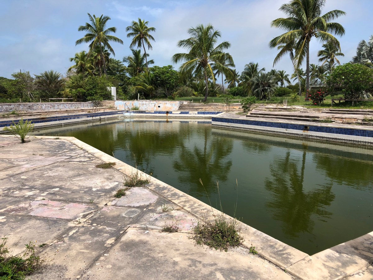
The next morning, about mid-morning, we headed ashore for the ¾ mile walk to the Club Med ruins on the Atlantic side of the island. I did a little online research about the place, which was spotty, and at times inconsistent. Best I could figure out, the location was originally the French Leave Resort in the 1960’s and was sold to Club Med in the latter part of that decade. Club Med was heavily damaged by Hurricane Floyd in 1999 and never reopened. Sometime in the early 2000s many of the structures were bull dozed in preparation for a new entity named French Leave to rebuild on the site. The rebuild never happened, although there is a small French Leave resort not far from the ruins. One of the structures still standing appeared to be an office, one room of which contained one of those blueprints cabinets with wide, shallow drawers. Only the drawers were all empty and the contents strewn about the floor. They appeared to be plans for the new resort that never materialized; one was dated 2006, so the timeframe fits. I’ll let the pictures in the video slideshow linked below speak for the rest of what we saw. I also found this link that includes several ca. 1960s post cards from when it was French Leave Resort (and one from Club Med).
When we returned to town we stopped for lunch at The Buccaneer Club, which we’d heard was good. It was. Got a few grocery items and some liquor; scored a whole case of Kalik Radlers Mango (hard to find) at half the price of buying the things individually. Kalik is a local beer; the flavored Radlers barely qualify, though. They’re mostly hummingbird nectar with 2% alcohol. No wonder I like them. The rest of our day was spent on Lady and very low key.
Our excursion the following day was to the Leon Levy Native Plant Preserve, but I’ll tell you about that one in the next post. I took lots of photos! Until then, stay safe and take care of each other.