Diving in the Abacos: Part 1- Fowl Cay National Park

General Overview of Our Dives

While in the Abacos from late May through mid July of 2021, we dove 10 times on 5 different reef systems. Two were small reefs inside the Sea of Abaco, that’s between Great Abaco Island and the small barrier islands to its east. The other three reefs were on the Atlantic side of those barrier islands, but we always dove the leeward sides (facing the barrier islands) because the conditions on the Atlantic side were either too choppy, or there was no place for us to anchor Indigo Lady and it was too far to dingy.

I always enjoy being under the sea watching the fish school along the coral heads, but this series of dives seemed more desolate than our Florida Keys dives back in August of 2020. I went back through the videos from our Florida Keys dives and finally realized what had been missing in the Abacos- fish! Okay, we saw fish in the Abacos, as you’ll see in the video, but we saw far fewer fish, less variety, and rarely any large fish or sharks. I would say the coral was about in the same condition both in the Abacos and Florida Keys, though perhaps a little worse off in the Abacos. I suspect Hurricane Dorian (early September 2019) had something to do with that. Still, there were fish to see, and I do find it peaceful to watch them from inside the fish tank, so to speak.

Fowl Cay National Park

The video that follows is a compilation of five dives done in Fowl Cay National Park over three days in June (two in early June, one in late June). The picture at the top of this post shows the area we explored.

The park was established in 2009. It used to have around twenty dive moorings one could pick up (with a small boat, not Lady’s size), but Hurricane Dorian removed many of them. There were about 6-8 left, or reinstalled, on the Grouper Alley/Flywheel Bay side, labeled in purple on the picture above. We dingied to these from Indigo Lady, which was anchored on the inside of the north end of Fowl Cay. When we dove the Twin Reefs/Tombstone area, labeled in green, we anchored Indigo Lady in a tongue of sand near the anchor mark in the picture and launched hookah from her sugar scoops (the stern steps).

Now settle back and listen to me breathe through my regulator as you as you enjoy the giant fishbowl of Fowl Cay National Park.

Coming out of radio silence

Greetings from New Hampshire! Yes, you read that right; we’re still in NH.

We were supposed to have rejoined Indigo Lady in the Bahamas at the beginning of this month, but yet again, we find ourselves delayed. Dave is in need of another surgery, poor guy. It’s not an emergency, but it is important. This morning he was finally able to schedule a surgery date for early March. It’s a day surgery, but he has to follow-up in person three weeks later. If all goes according to plan, we should be able to go to the Bahamas in April. Until then, he’s been instructed not to travel out of country, just in case. That means no Bahamas until he’s done and given the all-clear. So we wait.

I find it difficult to blog about travel and living on a boat when I’m stuck on land. At home in the fall of 2020, your may recall, I bombarded you with videos of our diving in the Florida Keys from August of that year. This past fall, however, I just wasn’t in the mood. I figured I’d take a four-month hiatus and restart in early January, back in the Bahamas. Well, it’s now late January and I’m not in the Bahamas, but I finally felt inspired to sort through the photos and videos from our short 2021 cruising season and that inspired me to restart my blog.

First up, a slide show of the artist trail we found on Manjack Cay, Abacos. I wrote about Manjack cay and the art trail and posted a handful of pictures from the trail this past July, but that was only a tiny fraction of the pictures I’d taken. I’ve whittled it down to 95 pictures and let the Photos app on my Mac create the slideshow. Don’t worry; it’s not 95 separate slides. I chose the origami theme, so you get several at once, and it’s set to music.

Enjoy the show, and until next time, stay safe and take care of each other!

Farewell Abacos, Hello (again) Great Harbor Cay

Our stint at Manjack Cay was our last touristy hurrah before heading back to the Berry Islands. We left Manjack the morning of Friday, July 9th and arrived at Great Harbor Cay in the Berry Islands mid-afternoon on Friday the 16th. Our focus at this point was readying ourselves and Indigo Lady for the two days we would take to get back to GHC and we decided to do most of the preparations at Marsh Harbor. 

We arrived at the little bay anchorage just outside of Marsh Harbor on the afternoon of Saturday the 10th. We spent three nights and three very busy days there. Sunday-Tuesday were all work, especially for Dave. In late June Dave discovered there was a leak in the port engine room around the rudder post. It was small, but no leak through the hull is good and small ones have a habit of becoming bigger, so Dave wanted to repair it before heading back to GHC. That repair took from 9:00 am – 7:00 pm Sunday (some of that time was waiting for JB Weld putty to dry). Monday morning we walked to Maxwell’s Supermarket for some final provisions. Back onboard I tended to the unpacking and moving around of provisions while Dave started cleaning our hulls. I made him stop about 2/3 of the way because it was late and he was exhausted. We barely mustered enough energy to heat leftovers for dinner and listen to music in the hammocks before bed. We got little sleep that night due to a storm that started around 11:30 pm and didn’t finish until after 3:00 am. Once again, the storm came from the only unprotected direction in the anchorage, making it bouncy and noisy with the waves hitting the hulls. We dragged ourselves out of bed just after 8:00 am Tuesday. Dave managed to finish cleaning the hulls after breakfast and I did some interior cleaning. Though tired, we decided to make the short 6 nm hop over to Hope Town knowing it would be a bumpy ride. It was, but it was short, and we were rewarded by a calm afternoon and night on a mooring and a final loaf of coconut bread from Vernon’s Grocery.

Wednesday morning we headed over to Lynard Cay. This was the first place we had anchored when we arrived in the Abacos in late May and it was now our launching spot for the return trip, retracing our steps around Hole in the Wall to Cross Harbor, then the following day from Cross Harbor to GHC. Lynard Cay to GHC is a 16-20 hour trip that we could do in a single shot, but I prefer to avoid overnight passages when they’re not necessary and it was not necessary in this case. The weather routing apps we use looked good enough to set out as planned at first light the next morning. We agreed that if conditions weren’t good we’d turn around and try again the next day.

As planned, we set off Thursday morning at 6:30 am, just as the sun was rising, and stuck our nose out into the Atlantic. The conditions weren’t perfect, but seemed doable, better than our trip up anyway. Conditions deteriorated about 2 hours out. We’re still learning how to apply all aspects of a forecast to a planned route. A forecast of 2-4’ seas from the SE with an 8 second period is based on the average top 1/3 of waves and assumes open water with no other influences; there can still be waves shorter or taller and from other directions. We did not account for the wind chop, which layers wind-driven waves over the predicted ones, and on that day the wind and seas were from different directions, which means we had waves from multiple directions- “confused” seas. On top of that, we were heading almost into some of the wave sets, which shortens the wave period making it bumpier. We chose to continue anyway for a few reasons. First, despite the bumpiness we were making better time than the trip up because the wind and some of those confused seas were more off our stern and giving us a bit of a push; it was only going to be an 8 our trip and we’d already done 2 hours. We knew when we made the turn to go around Hole in the Wall we would have the seas completely behind us and once around the point we’d be in the lee of Great Abaco where the water would flatten- that was another 2 hours of the trip. So I had 4 more hours of bumpy conditions to suffer through (the bouncing doesn’t really bother Dave). I’d taken one seasickness pill but should have taken two because I still wasn’t feeling great, mostly tired, and all I could do for 5 of the first 6 hours was stand and stare at the horizon waiting for the torture to end. Onward we trudged. I rejoiced when we made that turn to go around Hole in the Wall! We anchored in Cross Harbor by mid-afternoon and got a nap in before dinner (which I’d had the sense to prepare in advance) and we got a good night’s sleep. The next morning, Friday the 16th, was much better. We left at about the same time of the morning and had following seas the entire 8 hours. We were anchored in Bullocks Harbor by 3:00 pm and in the hammocks with celebratory drinks shortly thereafter.

We’re currently exploring the Berry Islands for the remainder of our time in the Bahams, which is quickly nearing its end. We have booked flights back to the US for mid August. We will pick up our car from my West Palm Beach cousins and start slowly driving home, stopping to visit family and friends along the way, assuming the stupid Delta variant of COVID doesn’t get any worse.

Next week I’ll tell you about our time in the Berry Islands. Until then, stay safe and take care of each other!

More about Manjack Cay

I was going to tell you about our 4 days and nights in the protected anchorage on Manjack Cay. We had arrived early in the evening of July 5th, the day that storm cell that blew in from the north, and we tucked into the north shore of the anchorage to be out of the biggest of the winds. 

The anchorage is a shallow bay about a half-mile wide on the Sea of Abaco side, and about half a mile across from the Sea of Abaco until you reach the junction of the two cays that form it- Crab Cay south to east and Manjack Cay east to northwest. Depths are about 5-9 feet (mean low water, MLW) for about a quarter mile in, then quickly drop to as low as 1 foot (MLW) as you near the cut between the two Cays. The southeast end of Manjack reminds me of a Maine lobster claw. The longer, upper portion of the claw on the Atlantic side curves gently from NW to SE, the tip pointing straight down at the narrow eastern portion of Crab Cay. The lower, shorter part of the claw runs east to west and points at the northern most point of Crab Cay. This yin/yang forms what the charts label Manjack Harbor, between the two cays. It’s not really a harbor, just a very shallow cut to the south and east leading to the Atlantic. If one turns NW inside the cut, you enter the space between the two halves of the Manjack “lobster claw” that forms a mangrove river running SE-NW for about three quarter of a mile.

The morning of the 6th, we were just getting into dinghy to head for the art trail we’d read about, when we were greeted by an older couple (my folks’ ages) in their tender. They had come over to say hello and ask about our boat. Turned out they own the property adjacent to the beach we were heading to. They told us to stop by after our walk if we saw them out and about. We continued to the beach and the art trail. It was a fun, interesting walk. Many cruisers and other vacationers who walk the trail contribute a piece of art made mostly of flotsam and jetsam (plastics, nets, etc.) and/or flora (palm fronds, coconuts) and fauna (shells and seabiscuits). Paint and markers are often used in the decorating. I took a ton of pictures and will eventually turn that into a slideshow, but for now you’ll have to enjoy the handful of pictures I’ve included here. Dave and I spent the afternoon and part of the next day ruminating over what our contribution would be and collecting raw materials when we walked on a beach the following morning. We ultimately decided to create something to represent us, so we made an Indigo Lady- as in a “lady” that was made of blue materials. Can you find her among the pictures in this post?

After our trail walk we decided to eat our granola bar snacks and look for the ocean beach trail. On our way there we bumped into the couple we’d run into that morning. They were doing yard work. Leslie and Bill have lived on Majack for almost 30 years; they hail from south Florida originally. They own about 5 acres and built everything on it. They are downsizing, however, and are moving to a new, smaller house they’re building a little further up on the bluff. Did I mention they’re in their 70s? They are installing enough solar in the new house to run AC, a small comfort for their aging bodies, as they put it. I’ve read comments other cruisers have written about the “lovely couple” on Majack who are very welcoming of cruisers. They are indeed. They have a little cabana on a post in the shallows of the beach that had swings on it pre-Dorian. They have some picnic tables in the shade at the head of the beach for cruisers to use, and a station for opening coconuts. They gave us a tour of their property and extensive gardens (which they also plan to downsize, a little). Leslie gave me some herbs from her garden; so sweet! Dave helped them hitch a trailer of rock wool insulation to his truck and we bid our farewells as they headed up the hill to install the insulation and we headed back to Lady for lunch.

The normal SE-ish winds had resumed. The wind was brisk, which set up a bit of chop across the open expanse of water (fetch) between us and the opposite shore making it a bit bouncy. After lunch we hauled anchor and tucked in near that opposite shore to reduce the bounce. Then we waited for just past low tide, around 2pm, and set out on a dinghy safari through the mangroves. We saw dozens upon dozens of small sea turtles, but no stingrays or young sharks, which we’d heard were often spotted here. At any rate, it was lovely and we went as far as water depth would allow, which was the back side of part of Bill & Leslie’s property where they have a dock onto the mangroves. Back at Lady we cooled off in the water off our stern for a bit and were just drying off in the tramps when we heard the approach of a dinghy. Two men and two women from the catamaran anchored in front of us had come over to say hello and ask about our solar-electric system. Dave had the guys come aboard the sugar scoop to see the engine room. The women stayed in the dinghy and I chatted with them a bit. We told them what we knew about things to see and do in the area. When they left us they were heading for the mangroves. We passed a quiet afternoon in the hammocks with fruity rum drinks.

After breakfast on the 7th we headed back ashore, this time to find the trail to the beach on the ocean side of Manjack. We arrived just in time to help Leslie and Bill stack one dinghy on top of another. Then we proceeded to the trail. It was about a mile walk through the woods to the beach. As we got nearer, we started to hear the surf, then see a preponderance of sand on the trail, and then the view. What a view greeted us! The water in dazzling shades of blue, the white sand, and we had it all to ourselves! We were sweating at this point, so we waded into the shallow water to cool off before combing the beach for “art” supplies. Once we’d had our fill (sun was getting higher and it was getting hotter), we headed back to the trail and to Lady for lunch. En route we encountered the foursome from the other catamaran and wished them a lovely day. We had lunch, then Dave got into the hammock to read. I made granola bars first and then got into my own hammock with a book (e-reader, actually). I started feeling creative around 5pm, so I pulled out our art supplies and we created our Indigo Lady, our contribution to the art trail. Just as we were finishing, my alarm went off to remind us that we had a Zoom meeting with our boating club (hello ABC-Portsmouth crew!). We had a strong enough signal to join with video; it was nice to see faces. We followed that with a late dinner and a short movie before bed. 

Next morning, the 8th, we dinghied ashore after breakfast to place our artwork on the artists trail. Then we went back to Lady, hauled anchor and headed back to the NW end of Manjack to see about a dive on the Atlantic-side reef. It was too bumpy on the larger outer reef to anchor dinghy, and no place to anchor Lady out there – too much reef and not enough sand. After cruising the inner portion of the reef a bit, we found a perfect tongue of sand to anchor Lady in and launched the hookah. It was nice enough, and good to be on another dive, but we’ve discovered that all the reefs in this section of the Abacos look the same, so it was a short dive. We were stalked by a 3-foot barracuda the whole time. Dave stared him down once; just like a dog, the ‘cuda looked down and away. He still followed us, though. We had lunch at anchor, then returned to our anchorage. As we ate dinner that night, we got to listen to a livestream of the Soggy Po Boys at the Lu (a friend’s barn/music venue in SW Maine). It was a fundraiser for our friends’ nonprofit- Continuum Arts Collective. Just as we finished dinner, it started to rain. So we listened to New Orleans Jazz while we danced in the rain (we may or may not have been clothed at the time). It was a refreshing evening, both because of the music and the cooling rain. 

Mid-morning on Friday the 9th we hauled anchor and started our trek south. It was time to head back to the Berry Islands. Here we are a week later, Friday the 16th, and we are on the last leg of our journey to the Berries as I type, hopefully arriving by mid afternoon. Next week I’ll tell you about our last few days in the Abacos and the two day trek from there to the Berries.

Until then, stay safe and take care of each other!

An interesting Fourth of July

I hope everyone enjoyed their Independence Day celebrations. We didn’t do anything here to celebrate, unless you count making burgers for dinner. Our “interesting” 4th of July had nothing to do with the holiday itself. Keep reading.

On the morning of the 4th we awoke to no breeze in White Sound, a harbor at Green Turtle Cay, and a bunch of mosquitoes hanging out on the screen door, fortunately on the outside. So right after breakfast we hauled anchor and headed for the anchorage on the NW end of Manjack Cay for hopefully fewer bugs and at least a little breeze. We were not disappointed.

We arrived at the anchorage around 10:30 AM to find two enormous catamarans rafted together at anchor; one 70 feet long, the other 82feet! It wasn’t 5 minutes after we set our anchor when we heard what we thought was a call for help. We saw splashing in the water between us and the shore and grabbed the binoculars to make sure it wasn’t people playing around. It wasn’t. The water wasn’t turning red either, so it wasn’t a shark attack, thank goodness. Perhaps I should clarify that last sentence. Tour boats feed sharks and rays in this anchorage, so I needed to know if I should grab the med kit. It wasn’t necessary. We saw a young man’s sit-atop kayak sinking underneath him. He was stranded, and panicky, probably because he knew there are sharks in the area. Nobody onboard the catamarans he came from seemed in a rush to help their own friend. They didn’t even attempt to drop their dinghy. One guy did, slowly, get ready to head over in another kayak. Really, people? So we dropped our dinghy and beat the kayak over. We got the young man into our dingy and towed the sunken kayak back to his boat. Interestingly, he asked how he could have handled the situation differently. We assured him there was nothing he could have done to prevent the kayak from sinking; it had developed a leak and the airspace just filled with water. We did suggest having a life vest with him if he’s not a strong swimmer, and to not thrash around if he’s concerned about sharks. 

After the rescue, we gathered our snorkeling gear and dinghied to mid-beach to snorkel from there. The SW corner of this anchorage is where tour boats feed the stingrays and sharks. I’m a bit of a wuss when it comes to sharks, so I wanted to start where there likely weren’t any. There were two small power boats in that corner, but they weren’t feeding the sea life, just hanging out on the fourth of July and swimming. We worked our way over there and did in fact see several rays, a couple of nurse sharks, a couple of small reef sharks, a sea turtle and a bunch of the same fish we’ve seen everywhere in the Abacos. More and more small power boats started showing up making it too dangerous for us to continue snorkeling, so we swam back to our dinghy and went back to Indigo Lady. 

We had ourselves a leisurely morning the next day and finally suited up for another snorkel just after lunch. This time we headed straight for the SW corner. There were no tour boats feeding the sea life and we had no intention of doing so ourselves. Turns out intention is irrelevant. As soon as we got within 20 feet of the beach, motor still running, the rays moved in. The mere presence of our dinghy was like ringing the dinner bell. There were half a dozen or more good sized rays skating in the shallows, in inches of water. As soon as we waded to our ankles they swam to and over our feet. A couple of 3-foot reef sharks showed up too but stayed 15 or so feet off the beach. I wasn’t excited about trying to get my snorkel gear on as I was being harassed by rays, so I let Dave get in first and draw them off. I’m so brave. Eventually I got in and we were treated to another lovely snorkel. The rays mostly lost interest in us once we were in the water with them. The reef sharks kept well away from us. A 6-foot nurse shark covered in remoras swam close by, followed by a smaller 4-foot one. Realizing we had no food, they lost interest quickly. At one point Dave stopped swimming and I saw a 6-foot reef shark swim past him about 10-20 feet in front. It leisurely disappeared into the dark beyond and we did not see it again. We also saw a fairly large sea turtle that Dave swam with for a bit. Getting back into dinghy was challenging. As soon as we were standing in the shallows again, there were the rays looking for food. We had to carefully work around them to get dinghy back into the water without stepping on them. I was afraid they’d get too close to the motor when we started it, but it all worked out. 

On our way back to Lady, we stopped at a smaller charter catamaran that had pulled into the anchorage earlier in the day. We chatted with the couple for a bit until it started to rain. We got back to Lady just in time to avail ourselves of the free fresh water to rinse off ourselves and our snorkel gear. There were clouds as far as the eye could see, so we had ourselves a little snack and decided to spend the rest of the afternoon watching movies. It was about 3:30pm. 

All day up until now, we’d seen rain cells passing to the east heading in a northerly direction. That means all the anchored boats were pointing southward, the direction the weather was coming from. As we were heading back to Lady from our snorkel we realized all the boats were pointing north, but the rain appeared to have come from the south. Curious. We didn’t think much more about it until the wind started blowing 25-30 kts kicking up 3-5 foot waves…from the north. Then the anchor drag alarm went off. Dang! We knew our anchor wasn’t buried well, but it was in what appeared to be a sand patch and it was south of a lip of mud and weed. Had the predicted SSE wind directions played out, we would have blown back on our anchor south to north, firmly rooting it in that mud & weed. Instead, we were blown north to south which just dislodged the anchor from what was apparently sand over rock. Rocna anchors usually reset if they drag, but we dragged 150 feet or more and our Rocna just skipped along the bottom. We decided it was unlikely we would be able to reset the anchor successfully with this wind and sea direction and this bottom, so we just pulled it up and headed south toward another anchorage 2 miles away, protected from the North. It was a pretty quick trip because once we rounded the point of the anchorage, the north winds and seas were at our backs giving us a push. Less than 90 minutes later we were anchored snugly in our new location. We opted for leftovers rather than cooking, and finally settled into our movie.

We would spend four wonderful days and nights in this anchorage and surrounding area, but I’ll write about that next week.

Until then, stay safe and take care of each other.

Which way to go from here?

Happy July!

We continue to enjoy our time here in the Abacos. Our friend, Ian, was with us for a little over a week. We did a bunch of diving and eating lunches ashore, enjoyed quiet anchorages, we even caught a tuna (and by “we” I mean Ian and Dave). It was wonderful to share an extended period of time with another human after more than a year of social distancing. (Thanks for coming, Ian!) He flew home this past Sunday. Dave and I did some boat chores, rested up a bit, then started planning our remaining time here in the Abacos. There is one more island we want to explore, Manjack Cay (also called Nunjack, locally), about 5-6 miles NW of Green Turtle Cay. We’re en route there now, but the timing of our arrival will depend on the path and timing of Tropical Storm Elsa. As with every day cruising, Mother Nature will decide. 

It may seem a bit early, but even as we head for Manjack Cay, we’re already thinking about how we will return to the Berry Islands for August. Again, we work on Mother Nature’s schedule and that is ever changing. We can’t afford to miss a good weather window. At this point we’re just exploring route options. My goals are to pick a route that (a) l is ikely to provide the most comfortable ride, (b) minimizes the number of days we just “make miles,” and (c) isn’t boring. We are weighing the pros and cons of each route. If we are incredibly lucky, we’ll be able to accommodate both goals, but I’m not holding my breath. There are a couple of options north from Manjack, or we can return the way we came via the south route around Hole in the Wall. From Manjack, the route distances are similar.

Going back the way we came means going back down to the area of Little Harbor and possibly waiting there for the right weather window to make the trip around Hole in the Wall. It would be a comfortable place to wait. This route would require us retracing our path through the Sea of Abaco. This isn’t a bad thing, because this is where we’ve been hanging out for the past 5 weeks and we like it here. We could transit the area quickly or take our time and revisit some of our favorite spots one last time. We know the anchorages and harbors we can avail ourselves of on this route. This route is not remote, well, compared to the north routes. The route from Cross Harbor across the Northwest Providence Channel to the Berries is a good angle for the prevailing seas and winds this time of year, plus we have our track line to follow and know we can anchor in the dark at GHC, so timing isn’t an issue on that leg of the journey. A potential disadvantage is finding a good weather window for the first leg around Hole in the Wall. We’ll be traveling SSW from Little Harbor and then NW a short distance up to Cross Harbor. This time of year, the prevailing winds and seas are E-SE. Winds under 10 knots and seas under 4 feet with a long period from SSE would be ideal. The more south or the more east, the bumpier the ride gets, unless the wind and seas are so light as to not matter. If we choose this route, we’re committed, because the other routes are too far north from Little Harbor for us to change our minds.

Alternately, we could continue northwest from Manjack Cay and then west across the top of Little Abaco and West End Cay, down into the Bight of Abaco to Mores Island, then from Mores Island cross the Northwest Providence Channel to Great Harbor Cay. This is a more remote route with many small, uninhabited islands. Remote and quiet can be very nice, when the conditions are good. This is also an exposed area with fewer anchoring options if winds shift in different directions. How much we would get to enjoy these quiet areas would depend on the weather. If we get a stretch of calm, we could dub our way to the Bight, otherwise we’ll find ourselves just making miles so we can get to the next protected area. A big advantage to this route is that the prevailing wind and sea directions this time of year would be in our favor, and the Bight tends to be calm unless winds are over 15 kts. One of the challenges of this route is the need to time our entry into the Bight with the tide at Spence Rock before continuing another 38 miles to Morse Island, with no option to stop in between. If mid tide rising isn’t early enough we’ll be trying to anchor at Mores Island in the dark. We’ve also heard that the Bight of Abaco is a thunderstorm magnet this time of year. Mores Island sounds like a reasonable place to wait for a weather window to cross to Great Harbor Cay, should that be necessary, and the route from Mores island to GHC is pretty good for the prevailing winds and seas. 

If we didn’t want to take the south route and didn’t want to risk the shallow Bight of Abaco and its potential thunderstorms, we could continue about 50 miles past Little Abaco and then turn south to enter the north end of the Grand Lucayan Waterway, a canal system that bisects Grand Bahama Island. Again, prevailing winds and seas are likely to be helpful, which is an advantage. We’d have to time our entrance across the shallow north entrance of the canal with the tide again, but once inside the canal system there are numerous offshoots in which we can safely anchor if we can’t transit the entire canal the same day. The angle from the south end of the canal system to Great Harbor Cay is less likely to provide a comfortable ride given the prevailing winds and seas. It would seem less likely we would choose this route. 

So there you have it, more information than you need about routes you probably don’t care much about. Dave and I keep wavering about which to choose. When we’re driving a car we will often return from a destination via a route different than that which we took to get there. Why go back the way we came when we can explore something else? It would be nice to check out the northern reaches of the Abacos, if the conditions were right. Alas, there’s no guarantee of the “right conditions” on the water, especially in a slow boat during hurricane season. Our decision point is Manjack Cay. When we’re done exploring there, we will have to commit to a route. Stay tuned!

Reefs and Recovery

Prior to the pandemic, when we thought last year was the real start to our cruising life, we did not plan to visit the Abacos because they’re in the extreme NW Bahamas, the opposite direction from the Caribbean, our ultimate target. Besides, they had just been hit by Dorian in September 2019 and were only about 6 months into their rebuilding efforts when we set out from Georgia in early February 2020. (If you’re new to my blog, read this post to find out why our boat was in Georgia). When we realized we wouldn’t have a full cruising season again this year we talked about what we would or could do given the ongoing pandemic and Dave’s hand surgery and recovery timeline. Regardless of where we chose, we knew Indigo Lady would be in the hurricane belt for the entire hurricane season, with us on board for part of it. We also knew we couldn’t go too far. 

As lovely as it would have been to see more of the Florida Keys, we didn’t want to delay our trek to the Caribbean any longer. The Bahamas are the first leg of that journey for us and they have a wonderful hurricane hole in the Berry Islands where we can leave Lady when we go back home to New Hampshire this fall. Extra bonus, when we resume cruising next January we don’t have to cross the Gulf Stream; it can take weeks in the winter to find the right weather window to do so. Now the Abacos seemed like a viable destination. Other cruisers rave about it as a destination for its friendly people and the beautiful diving and scenery. We knew we could easily spend a couple of months there exploring. They could use all the visitors they can get, too, since their economy relies heavily on tourism, which they have not had a lot of these past two years. To the Abacos we would go.

We have been in the Abacos coming up on four weeks. We’ve had several days of diving and have explored each island we’ve been to. From what I’ve read, the reefs have been declining over the years, some due to increased tourism but mostly due to the changing climate. Still, they’re in better shape than I expected. There have been a couple of beautiful dives with a good crop of healthy corals and small reef fish, others have been mostly brown with either remnant healthy corals or returning corals, hard to tell. The Bahamian government has been creating more coral & fish preserve areas since the early 2000s and there are several here in the Abacos. No fishing is allowed in these areas and you have to either anchor in sand, avoiding all coral and sea grass, or pick up one of the dive moorings, few of which remain after Dorian. I’m glad to see these efforts. Hopefully they’re making a difference. Our friend Ian is with us for a little over a week. He dove this area about 20 years ago, so it will be interesting to hear from him how the reefs have changed over those two decades. 

Thus far we’ve spent time exploring the out islands of Elbow Cay, Man-O-War Cay, Great Guana Cay, and Green Turtle Cay. These are barrier islands facing the Atlantic, on the east edge of the Sea of Abaco. We spent one night at anchor outside of the private canal development of Leisure Lee on the “mainland” of Great Abaco Island on the west side of the Sea of Abaco, and a couple of nights at Marsh Harbor, also on Great Abaco. These places are at varying stages of recovery. Hope Town, on Elbow Cay, and Green Turtle Cay seem to be the furthest along. Marsh Harbor is still looking wrecked. Dorian first made landfall in the Bahamas over Elbow Cay (Hope Town) with 1-minute sustained winds of over 180 mph and gusts over 200 mph. It crawled slowly over Grand Bahama and didn’t weaken for a couple of days and even as it eventually did weaken, it pulled northward slowly. Most of the locals were stuck here during Dorian. I can’t imagine the terror they felt or the emotional scars that experience left, especially on the children. One woman we spoke to on Green Turtle Cay told us that families moved from one house to another during the storm; as one was destroyed, everyone moved to the next. 

There is a lot of active rebuilding in all these areas. It is through the unquenchable perseverance of the locals, supported by numerous aid organizations, that these islands are making their comeback. We see barges running back and forth between islands with heavy equipment and building supplies. On every island is the sound of saws and hammers and the sight of stacked new building supplies waiting to be used. On Green Turtle Cay we watched a house being demolished and loaded into a dump truck for removal. Something new will take its place. Each island we’ve visited has at least one open restaurant, a couple of open shops, and a grocery store (although the one on Great Guana looked closed to us). We’ve been able to find fresh produce easily, which I wasn’t sure would be possible in a remote area like this that’s still recovering from a hurricane. We’re going to have to remember to actually eat all the frozen veggies we stocked up on in the U.S.!

The pandemic hasn’t made the recovery any easier. At least 50% of the Bahamas’ economy relies on tourism one way or another. The Bahamian government has had to balance the need for tourism dollars with the need to keep its people safe from COVID. They have opened up more to travelers, requiring pre and post-arrival testing for those unvaccinated. As of May first, fully vaccinated travelers with proof of vaccination can forego the testing requirements. Masking and social distancing remain in place, with varying degrees of enforcement on the different islands. They have started a vaccination campaign here, and still impose island by island shutdowns as warranted to control spread. 

There are other parts of the Bahamas we could have explored this year, equally as beautiful, equally as close to the Berry Islands where we will end this cruising season, but not devastated by the hurricane. We decided that this is a small way we can support their rebuilding efforts; show up and spend money. We’ve pulled into the harbors that have moorings and paid the (remarkably small) fee to support the mooring owners, which have surprisingly not been big marinas. We tour the town on each island and while ashore buy lunch, a handful of groceries, sometimes treats at the local bakery, and mementos and gifts in their shops. We’ve purchased some groceries in each location and some small mementos and gifts from their shops. We also learned that there is a way to donate online to support the dive moorings. We don’t care about amenities; we have everything we need onboard. Some islands have multiple lunch options, others only one. We don’t care, they all serve fabulous food. We can see hints of what the Abacos were before Dorian and why people flock here by land and sea each year, why other cruisers rave about the Abacos. Sure, we’re missing out on meeting a bunch of other cruisers, but we also don’t have the typical crowded anchorages and mooring fields and we’re having some great conversations with locals. We’re having a wonderful time. I’m glad we came.

It’s been a tough two years for the residents of the Abacos, and it will take them years to completely rebuild. If you feel so inclined, there are numerous ways to support the residents of the Abacos in their rebuilding efforts. Please share this link widely. (I’m just passing along information; I don’t get any compensation for advertising this list.)I’ll leave it at that. Stay safe and take care of each other!

This is the Abacos
But so is this

Diving the “Coral Gardens”

Sorry I didn’t post last weekend as promised. We were too busy enjoying ourselves. I believe I promised you a description of our first real dive here. 

I don’t know who named this area “Coral Gardens.” I suspect it was a local dive shop. At any rate, it was definitely worth backtracking to dive here. We knew there were dive moorings for small boats, so we couldn’t take Lady over. Instead we loaded the hookah system and our gear into dingy and made the 1.5 mile run to the dive site. The site is across from one of the cuts between barrier islands out to the Atlantic side and there was some swell coming in. Fortunately, a wet dingy ride doesn’t matter when one is going diving. There was nobody else there when we arrived around 10:15am, so we had our pick of the dive moorings. We picked up the one in the center so we could swim easily in either direction depending on the swells, which there were, and any current. As soon as we picked up the mooring, a little sea turtle came over to greet us. It was then that I realized I’d left my underwater camera on Lady! Argh! Of course the little turtle swam around our dingy and hookah the entire time we were preparing for the dive and I couldn’t get any photos <sigh>. He skedaddled as soon as we got in the water.

I was amazed at how big the reef was, given that it’s on the inside of the barrier islands and not on the Atlantic side. It was probably a couple hundred yards long; we didn’t dive the whole length of it. At the deepest point it was about 20 feet tall. There was plenty of reef all the way up to the surface for snorkelers to enjoy as well. There were many fish, small ones, like a nursery reef. 

The current on top of the surge was tiring, so our first dive was only about half an hour. When we came up for a snack and some water, all the moorings were occupied! Another dingy was sharing our mooring and had some snorkelers off it’s stern in the shallow part of the reef. We chatted with the guy driving that dingy, had a bit of a rest and went back down for another, slightly longer dive. The current had abated and we stayed in the deeper part where the surge wasn’t as strong. When we came up again, our neighbor dingy was gone, and the boats on the other moorings were just preparing to leave. 

Once we got back to Lady, we put our toys away before having lunch. “Putting our toys away” is about a half hour process. We have to get the hookah and hoses back onto Lady from the dingy and rinse it all with fresh water. Then we have to rinse all our gear and ourselves and set everything out to dry. On diving days we always spend the rest of the afternoon relaxing, not that we need and excuse to relax.

We were preparing to return to Coral Gardens the next day in the afternoon when we saw dark clouds and rain not too far away. Good thing we hadn’t taken off in the dingy yet, because it would not have been fun to get stuck in that squall out in dingy! It only clipped us with some showers and winds on Lady but went right over the dive site. Our plans thwarted for that day, we hunkered down inside for the rest of the afternoon. The following day we did return to Coral Gardens and this time I remembered my camera. So I’ll stop blabbing and let the video speak for itself. Enjoy!

FYI, it takes too long to put together these videos and I’d rather spend my time down here doing other things. Further videos of our exploits in The Bahamas will have to wait until we get home in the fall, just like I did last fall after our dive trip to the Florida Keys. (If you don’t know what I’m talking about, scroll back to my posts from September-December 2020. That was some great diving!)

Be safe, and take care of each other!

First days in the Abacos

Now where did I leave off last time? Oh, yes, we were anchored at Lynard Cay after that bumpy Tuesday passage that made me seasick. Moving on to last Wednesday.

After breakfast last Wednesday morning we set off for Hope Town where we finally caught up with our friends, Rich and Cathy, and their big golden retriever, Bernie, on board M/V Angeleno. Thanks to those winds that kept us at Great Harbor Cay for so long, what should have been a week with our friends ended up being only a couple of days, but at least we got that. We picked up a mooring next to them in the harbor and they dinghied over and took us to lunch at the marina. (Thanks again for lunch!) After lunch we walked up the Hope Town Lighthouse, the only remaining manned lighthouse in the Bahamas. We were treated to spectacular 360o views after climbing the steep 100+ steps to the top. On our way back to the dinghy we looked in at the two small grocery stores to see what they had and bought a few pieces of fresh produce. We shared drinks, snacks and then dinner on their boat and returned to Lady for bed.

Thursday morning Dave and I went ashore for a walk through the town. We stopped at Vernon’s Market & Bakery to buy some fresh made pastries and a couple of produce items for dinner that night. On the way back to our dinghy we stopped at Captain Jack’s and got a bottle of rum. We’d heard rave reviews about their restaurant, but they are still rebuilding from Dorian and won’t open until later this summer. At least their liquor store was open! We ran into Cathy, Rich and Bernie on our way out of Captain Jack’s and decided to return to our boats and prepare to head out of the harbor and up to an anchorage off Dickies Cay outside the mouth of Man-O-War Cay harbor. Cathy and Rich needed to leave early the following morning to start their trek home, and the rising tide out of the harbor next morning would not have been conducive to an early departure. Not having a dog to tend to and no need to warm up our electric motors before departure, Dave and I enjoyed the delicious apple cinnamon scones we’d purchased at Vernon’s while our friends prepped their boat for departure. 

By late morning we were headed out of the harbor and traveled the 4 nm to our new anchorage. An hour later we were rafted together on Lady’s anchor and very cozy. If you’re not familiar with the term, “rafting” is when two boats tie up alongside each other, usually with only one boat’s anchor holding them in place. It allowed us to easily pass between boats, and Bernie always had his humans within sight. We made our own lunches and ate in Lady’s cockpit, retired to our own boats for some down time, then reconvened on Lady for afternoon drinks and snacks, followed by dinner, with brownies, and more rum, for dessert. We all headed for bed around 9pm.

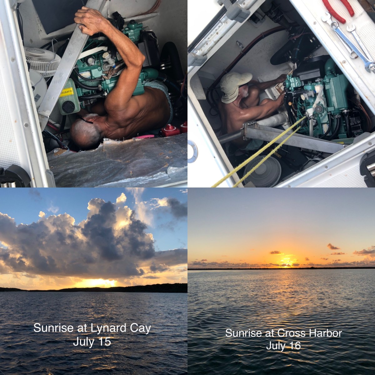
We bid an early farewell to Cathy, Rich and Bernie Friday morning as they started their trek back to the U.S. Dave and I stayed in place and on the boat the rest of Friday. We did some boat chores, pulled out our charts and loosely planned our remaining time in the Abacos, then relaxed in the hammock with our books the rest of the afternoon, had dinner, and retired to bed fairly early. I was still pretty exhausted from Tuesday’s passage and very much needed and appreciated the low key day.

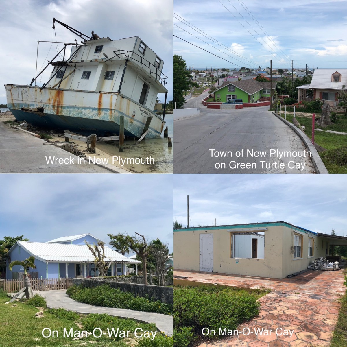
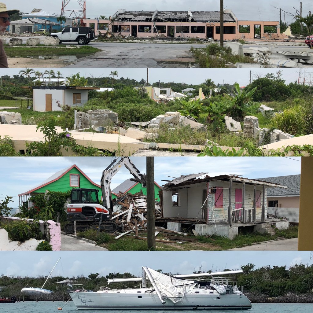
Dave and I set out to dinghy ashore Saturday morning swinging by the catamaran, S/V Tribute, that had just anchored behind us, to say hello. We met Jeff and Melissa, chatted for a bit and planned to meet up for drinks and appetizers later. Dave and I continued into the harbor, tied dinghy to their shiny new public dock, and took a walk. The Abacos were devastated by hurricane Dorian almost two years ago, and the pandemic followed closely on its heels. The islands are in various states of recovery from the hurricane. Man-O-War Cay is a small island with a small resident population of just over 200, but they’re making progress and there is a lot of rebuilding occurring now. As I said, their public dock is new. The Hibiscus Café near it was open as was an amazing coffee shop, which we found on our walk back into town from the outskirts. Lo and behold, we ran into Jeff and Melissa! We all sat outside in the shade enjoying our sinfully sugary treats and drinks, chatting up a storm. We eventually went our separate ways planning to meet on their boat later that evening. We stopped in the grocery store across from the coffee shop and struck pay dirt! It was the biggest, best stocked grocery we’ve seen so far. By U.S. standards it’s very tiny, but for these small islands it was a bonanza. We didn’t need much, but did buy a few items, especially fresh produce! On our way back to dinghy we ordered takeout from the Hibiscus Café. We killed our half hour wait time by walking out of town in the other direction a bit. We chatted with a local man also waiting for his lunch. We learned from him that the resident population of Man-O-War is about 210/220, down about 30-40 people since Dorian, when several left. We also learned that about half of the houses on the island are owned by locals and the other half by foreigners, mostly from the U.S. We bid him farewell when our food was ready and returned to Lady for our late lunch and a relaxing afternoon.

At 6:00pm we headed over to Tribute with some homemade hummus and a pitcher of our boat signature drink, called Indigo Ladies, of course. Jeff and Melissa had out a yummy spread of apples and carrots (more fresh produce!), crackers and dip. Their boat is amazing! It’s a new build, HH50 high performance, all carbon fiber 52’ catamaran. Dave geeked out while Jeff showed him all the cool technology. It’s also a beautiful living space. I’ll let you google them if you want to know more about this amazing vessel. 

We talked non-stop until almost 9pm. We come from different backgrounds, but Dave and Jeff have the same corny sense of humor, Melissa and I weren’t really boaters until we met these guys (who have been around boats forever), we all retired early, we’re all new to living aboard, and we have similar world views. They are heading up to cruise Maine for the summer, our old stomping grounds. Jeff made an interesting observation while we were talking. Where, other than within the cruising community, do people meet strangers for the first time and invite them over for drinks? You don’t turn to the person behind you in the supermarket line and invite them over for drinks. Jeff is so right! We meet all sorts of fun and interesting people cruising and it is especially nice to meet kindred spirits, as we did meeting Jeff & Melissa. We will surely stay in touch, but it’s still a bit sad to have to bid farewell so soon after meeting. Hopefully our paths will cross again next cruising season, somewhere in the Caribbean.

Sunday at lunch time we hauled anchor and ate underway as we backtracked 12 miles to Lynard Cay. Jeff and Melissa raved about snorkeling at “Coral Gardens” off Sandy Cay just two miles from the Lynard Cay anchorage. Wildly Intrepid had also told us about this fabulous spot, but we figured it just wasn’t in the cards since we had really wanted to catch up with our friends in Hope Town which was past Coral Gardens. Now that two couples raved about it, we started to think we may not want to miss it. It would also give us the chance to stop in Hope Town again, which I wanted more time to explore. We’re not really on a schedule, so why miss a hot snorkeling spot? So backtrack we did. We were at anchor back at Lynard Cay in time for afternoon drinks and hammock time.

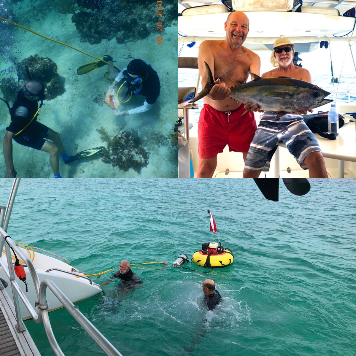
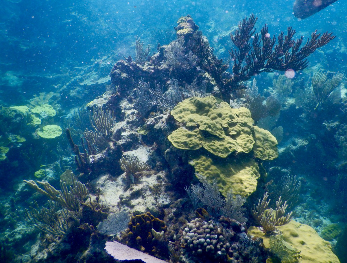
How was the diving? You’ll have to wait until this weekend’s post to find out. Until then…

Stay safe and take care of each other!’

Berry Islands to Abacos

Two weeks ago we were anchored in Bullocks Harbor off Great Harbor Cay in the Berry Islands, waiting out a big blow of indeterminate time. The winds lasted about a week, so we had extra time at GHC. Since I’m catching up on two weeks, you might want to grab a drink or snack and settle down someplace comfy before you continue reading; this is a long one.

We spent a couple of days exploring by bike. Those folding bikes we’ve been hauling around since 2019 finally earned their keep. We found Shell Beach, which despite its name had no shells, at least not the day we visited. It did provide a lovely walk on a soft, white sand beach, however. It’s on the Atlantic side of the island, so we could see the impact of the big winds on the seas. We also found the resort ruins up the hill from the marina. It must have been quite something back in the day. There was one cement staircase we were able to climb for a more top-down view. The remains of the courtyard include the old pool filled with accumulated rain water now. There’s another ruined resort at the north end of the island that we want to check out when we go back in August, Sugar Beach Resort. We’ll also have to talk to the locals and find out the history of these abandoned resorts. 

We had lunch one day at Brown’s Garden and had a long conversation with the wonderful owner, Ronnie. His wife cooks a delicious meal! We’d hoped for lunch another day at Hammerheads, but it was closed, so we got a quick takeout lunch at the Whitewater Grocery & Restaurant. We both ordered a club sandwich. It was kind of comical. The woman taking our order was telling us it had turkey, ham and bacon, oh, but they were out of bacon. No problem, we can live without bacon. About 5 minutes later she found us in the grocery aisles to tell us they were also out of tomato. I said, “That’s okay, we’re out of tomatoes on our boat, too. We can do without.” Because of the big winds, the mailboat, which also brings food to the island from Nassau (which gets it from the U.S. mostly), had been unable to deliver. That has to be very difficult on the locals when that happens, especially with there being only two tiny grocery stores on the island. 

The best part of being stuck at GHC for 10 days was that we finally caught up with a couple we met in the Dismal Swamp back in mid-November of 2019. We met Alex & Corey of Wildly Intrepid on a clear, chilly afternoon when eight boats transited from the north lock to the Visitor Center dock and tied up for the night. We chit chatted a bit that evening and again the following frosty, 31oF morning. We’ve followed each other on social media since then, but the pandemic had prevented us from meeting up again, at least until the big blow at GHC. We were pleasantly surprised to find that we were finally on the same island chain! They were down at Hoffman Cay (where we had spent two pandemic weeks in March 2020) and were heading to GHC to be out of the winds and to stage to cross back to the U.S. Over the week that we shared the anchorage, we snorkeled a couple of times, walked ashore a bit, and shared several dinners and late nights talking. It was so fun to get to know Alex and Corey beyond their social media (which you can check out yourself on their Wildly Intrepid YouTube channel or their Instagram @Wildlyintrepid). This is one of my favorite parts of cruising, meeting interesting and fun people. It’s always a bit sad to say goodbye, but who knows, our paths may cross again in some unexpected place. 

On Saturday, May 22nd, Dave and I were taking the dingy into the marina to ask a question, when another couple we met in the anchorage waved us over (hello Bob & Pam on Porkpie!). They had just heard that the island was going into lockdown for two weeks and if you went ashore you were stuck. So back to Lady we went and turned on our VHF. Early afternoon, the Royal Bahamas Defense Force (RBDF) broadcast that all boats in the marina or harbor were prohibited from leaving, they even put a military vessel at the mouth of the harbor to emphasize the point. We were told to hail the RBDF with questions, so we did. They gave us instructions to call the local police to get their okay to leave. Okey dokey, we called the police. They were fine with us leaving and told us to hail the RBDF again and tell Lt. Cox that we were okay to leave. Right-O, back on the VHF to hail the RBDF. We relayed the message from the police, but since we weren’t leaving until Monday, we were instructed to hail them right before we left. Dizzy yet? We felt fairly confident that we’d be allowed to leave Monday, but we had one additional step we needed to take anyway. Cruisers are supposed to submit domestic travel health visas when they move from one island group to another. Sunday morning I submitted ours to move from the Berries to the Abacos. They were immediately approved; one more piece of documentation that we were allowed to move. Monday arrive and we saw that Wildly Intrepid had already left for the U.S. Surely we’d be allowed to move, too. Dave hailed the RBDF at 6:00 (before coffee!), gave them the spiel of everything we’d done to get approval and they approved us to leave. Sweet! Not two minutes after our approval, four other boats hailed the RBDF also seeking approval to move on. We started something.

We had a lovely cruise Monday across the Northwest Providence Channel to Cross Harbor on the west side of the south end of Great Abaco Island. It’s not really a harbor, but it was a great anchorage for the calm night, in crystal blue water. We were up early again Tuesday and on our way around Hole in the Wall, the southernmost point of the island, and up the east coast to Little Harbor. About 10 minutes out, we were joined by several dolphins who played in our bow waves for about 15 minutes! I never get tired of watching dolphins do that. Unfortunately, that was the only good part of this leg of the trip. As we neared the point, the seas were not as forecast and it was a miserable 10 hours for me. The seas and winds were almost on our nose, a little to starboard, but the seas were a bit confused and from a couple of directions, so it felt like we were in a washing machine. I was mildly seasick most of the final 8 hours. I never used to get seasick, grrrrrr. The seasickness was exacerbated by the spasms in my midback, which alone can make me feel a little off. I munched on crackers and other carbs all day. I got a couple of hours reprieve when we got to a point where we could change course about 50o to port, aiming toward land while still making forward progress to our destination. This put the wind and waves more on our stern, which doesn’t bother me. Eventually we had to beat back into the seas and winds to get around the next point of land before the cut we needed to pass into. A couple of hours after that we were turning west into the cut for Little Harbor and soon thereafter the reefs and small outer islands cut down the swells and my tummy settled. We anchored off Lynard Cay for the night, a couple of miles north of Little Harbor. Lesson learned, take seasick medications before any long, open-water crossing, just in case, and keep more seasick meds onboard.

It’s almost 5pm and Dave has been in the hammock for about 20 minutes with his drink while I sip mine and type this. Something is wrong with this picture! This is long enough already, so I’m going to stop here and pick it up later with a bonus mid-week post, so stay tuned. I promise to try to post weekly from now on, somewhere between Friday-Sunday.

Stay safe and take care of each other!