Barbuda is better. Much better!
We didn’t do much in Antigua after my last post on 4/26, other than prepare for the arrival of our friend, Ian. We moved back to Jolly Harbor, did a little provisioning and some boat chores. Ian arrived Sunday afternoon and we just talked the rest of the day, through dinner and until bed. The morning of the 29th we popped ashore so I could use some WiFi and see a doctor to make sure there was nothing wrong with my right ear, which had been off and on extremely itchy deep in the eustachian tube. Other than a little irritation, all was clear. Good. That afternoon we moved up to Dickenson Bay at the NW part of the island to stage for our jump to Barbuda the following morning.
We hauled anchor around 8:00am the morning of 4/29 and had a comfortable 6-hour cruise up to Barbuda. Thus far, it’s been the most comfortable crossing we’ve had this season. We were anchored up near Codrington Lagoon by 2:00pm.
Barbuda, with a population around 1600-2000, lies about 30 miles north of Antigua. Together with Antigua, they gained their independence from Great Britain in 1981. Barbudans didn’t necessarily want to be part and parcel of a single nation-state with Antigua, and their relationship is fraught, to say the least, especially since Hurricane Irma, but that’s a story I don’t know much about. The 62 square mile island’s length is oriented NW to SE. It is composed largely of limestone and volcanic rocks from a long-extinct volcanic arc. The highest point of land on the east side tops out at about 125 feet above sea level. The west side of the island is characterized by Codrington Lagoon, a saltwater lagoon about 6 miles long and about 1½ miles wide at its widest point.
For most of its existence, the lagoon’s connection to the open ocean has been an inlet through the mangroves on the northwest corner of the island. It is otherwise separated from the open ocean by a long, narrow, sand spit. Codrington Lagoon is ecologically important for several reasons. First, it serves as the nesting grounds for the largest Magnificent Frigatebird colony in the world. It is also home to several other bird species, the rare Antiguan racer snake, and the smooth-headed iguana. It is a nursery for lobster, conch and fish that are important to the Barbudan economy. For example, they export lobster throughout the world. The lagoon and its sand spit also protect the island’s main settlement of Codrington from impacts of storm surge and hurricanes. In the past, two hurricanes (one the 1960s and the other in the 1990s, I believe) have breached this sand spit, but it repaired itself within two years or so. Hurricane Irma in 2107 breached this divider again, only instead of repairing itself over the past several years, the breach has become wider, reaching almost 2 miles! If this breach doesn’t repair itself, it will have lasting impacts on the island and its inhabitants, both human and non-human. (Cited from Smith Warner International.)
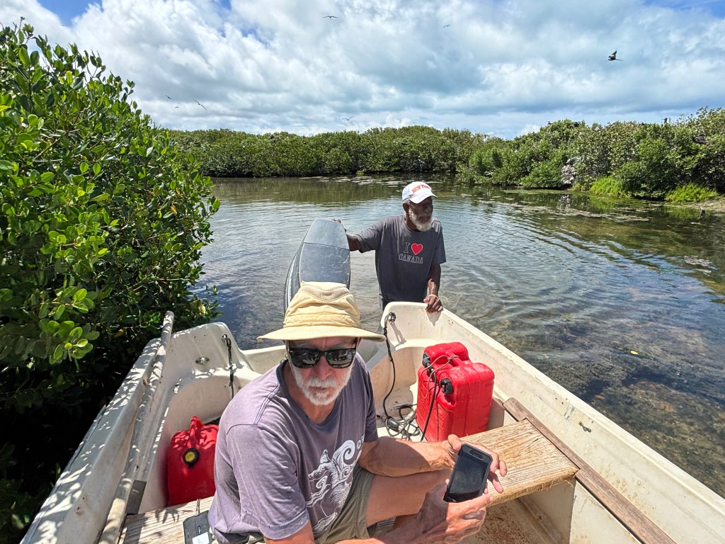
The morning after we arrived at Barbuda, we set out in dinghy at 8:30am to meet our guide for the Frigate Bird Sanctuary, a tour we had arranged before our arrival. We met George Jeffrey at the Codrington fishing dock, and the three of us, plus two other cruisers set off with George to see the birds. The first stop he made was well outside of the sanctuary where George told us a bit about the sand spit breaches I mentioned before, plus a little about the current troubles between Barbuda and Antigua. Then he took us to a small sandbar where he stopped again. That sandbar, devoid of all but a handful of tiny new growth mangroves, is the former site of the sanctuary. In 1960 (maybe 1961?) a hurricane hit Barbuda. Before its arrival, the Frigatebirds flew off to evade the storm. Upon their return, they found their mangroves gone, so they just flocked to another section of mangroves a little further north, and they’ve been there ever since. Then it was time to meet the birds.
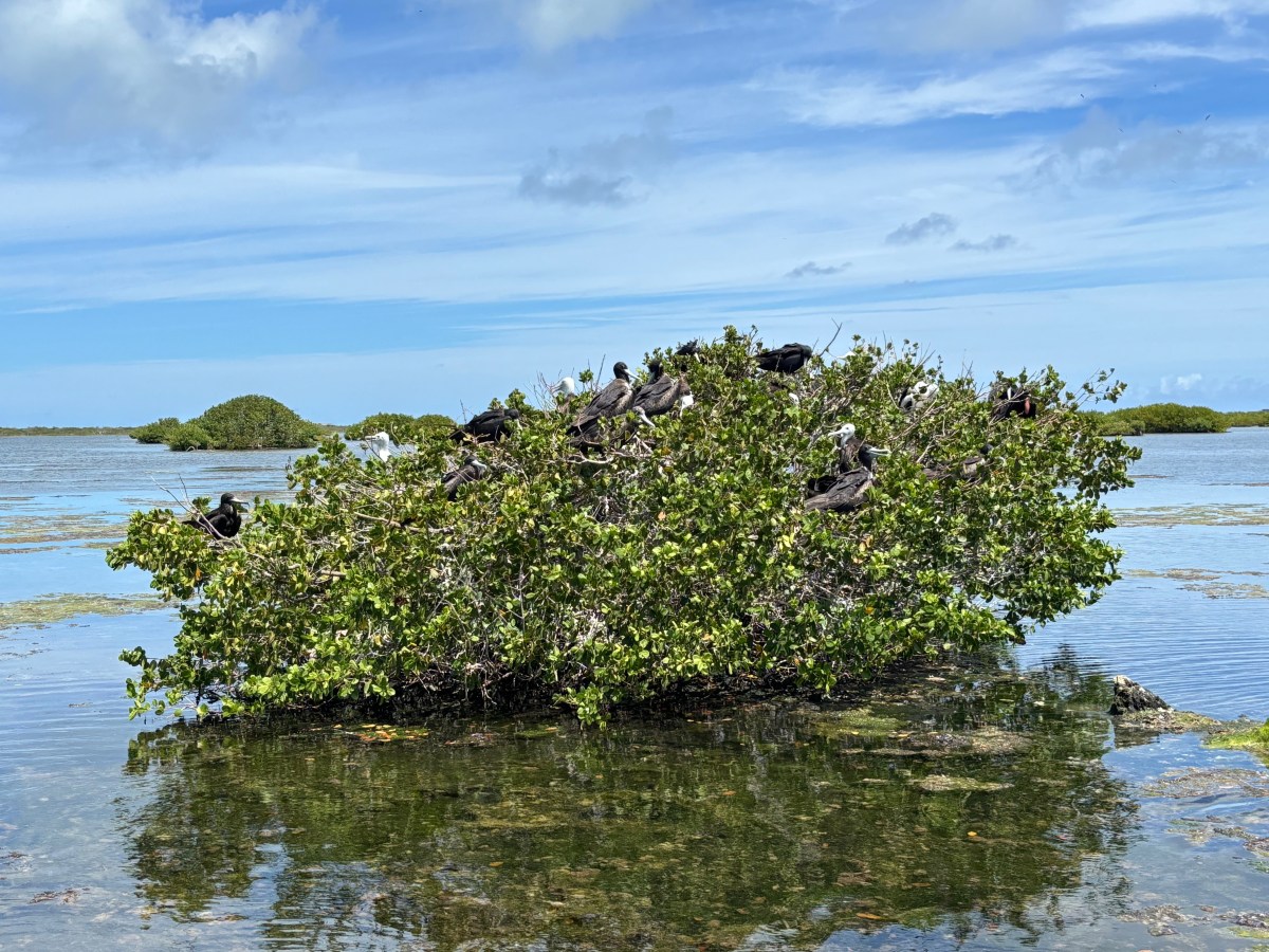
What an amazing sight! In a stretch of mangroves approximately ¼ x ¾ of a mile, are thousands upon thousands of birds (I’ve seen estimates ranging from 12,000-20,000). The mangroves were heavily laden with (mostly female) adults and chicks of various ages. They were squawking, but it wasn’t as loud as I’d expected. George got out of the boat and slowly maneuvered us through the shallow waters, through upsidedown jellyfish-infested waters (they don’t sting) around the mangroves so we could observe them closely. We spent about a half hour just watching the birds. They are the national bird of Antigua & Barbuda and are on the Barbudan flag. George told us a bit about them, and I looked up more information later, all of which I share below (and include the links I used so you can read more if you like). There are pictures at the end of this post.
Frigatebirds are agile aerialists, that can fly for days on end, but they don’t go into the water. Their feathers, in fact, are not waterproof; they would be unable to lift themselves back out of the water. They feed on small fish (locally, flying fish are a favorite) which they scoop from the water’s surface, or steal from other birds. Adults are about 3½ feet long (beak to tail) with a wingspan of about 7½ feet. They have a deeply forked tail. All adults have black feathers, but the females’ chests are white while the males sport a bright red throat pouch. That throat pouch is how they woo females during mating season, which generally runs from September-April (peaking in December), which explains why we saw chicks of varying ages. Once a female has chosen her mate, the two build a nest where the female deposits a single egg. Both parents share the work of incubating the egg, which lasts about 50 days, and then feeding the chick. The males take off after about three months. The chicks fledge at about five months. The female continues to feed the chick for another four months or so. The chicks are fuzzy white and grow into their black feathers over time, with their heads changing color last. We saw newer chicks of fluffy white with only a few small black feathers forming on their wings, and we also saw older chicks just waiting for their heads to go black. (Audubon)(Lonely Planet)(Wikipedia)
Codrington Lagoon, where this colony resides, became a National Park in 2004. One can only enter the sanctuary with a local guide. The National Park only charges $5 per person to enter the sanctuary. Our tour with George cost $60 for all five of us together, so $12 per person. If you’re ever in Barbuda, I highly recommend taking this tour. If you can’t get George, there are several other guides as well.
The day after our Frigatebird tour, May 1st, we hauled anchor late morning and moved Lady to a reef anchorage on the south side of Barbuda, settling in Gravenor Bay. We spent two nights there, and this morning we moved about a mile closer to Spanish point at the southeast end of the island. There is a lot of shallow patch reefs to explore in this area, and we’ve explored many of them over the past 3 days. These are not very healthy reefs, but they’re better than what we’ve seen in Antigua. They are certainly heavily storm damaged, as evidenced by the coral rubble, and they also suffer from what ails all the reefs we’ve snorkeled and dived on in the Caribbean- bleaching, disease, and overuse (by incautious tourists). Unlike our experiences in Antigua, however, there is more sign of recovery here. We did not see any sponges, but there were many corals. A large number of them were sea rods, but there was quite a variety of other corals as well, just in smaller numbers. There were the usual fish suspects, and we saw several southern stingrays and sea turtles, and Dave saw an eagle ray. It was nice to finally have some snorkeling worth doing, and it was encouraging to see the regrowth.
Either tomorrow or Monday we will head back to Antigua to do some snorkeling on the north side reefs. Then we may move south to Falmouth Harbor to do some snorkeling there and explore the island’s interior by car before Ian returns home.
Until next time, stay safe and take care of each other!