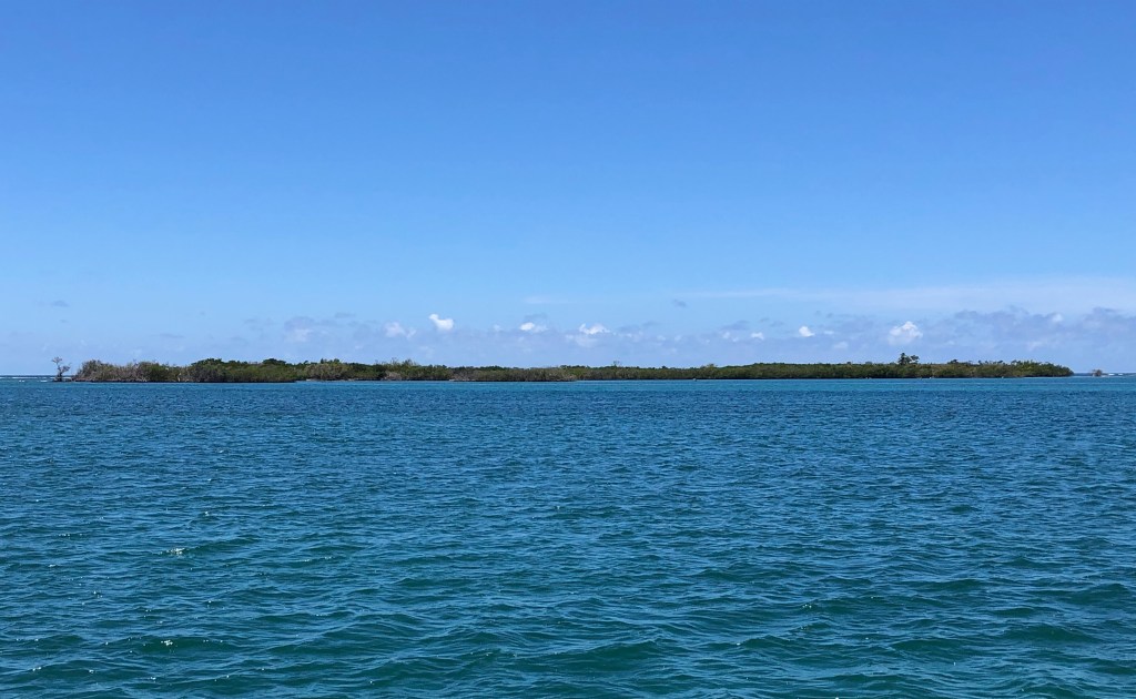
Okay, the Gilligan’s Island we went to has nothing at all to do with the famed TV series. Its real name is Cayo Aurora and it is one of three islands that make up the Cayos de Caña Gorda, managed by the Department of Natural Resources (DRNA). It’s about 1 nm off the coast of Guánica. I think I read somewhere that the person who named it sort of looked like Bob Denver (that’s the actor who played Gilligan), but I can’t confirm that.
Gilligan’s Island is a small mangrove island. It used to be quite the weekend hotspot for locals and tourists alike. There was a long dock where the hourly ferry from the mainland would drop off day trippers. Tourists at the resort in Guánica could rent kayaks and paddle over. Locals would bring their own boats over on the weekends to pick up a mooring ball and spend the day enjoying the water in the mangrove creeks or at the tiny beaches tucked among the mangroves. There were covered picnic areas with brick fire pits, changing huts, and a bathroom facility.
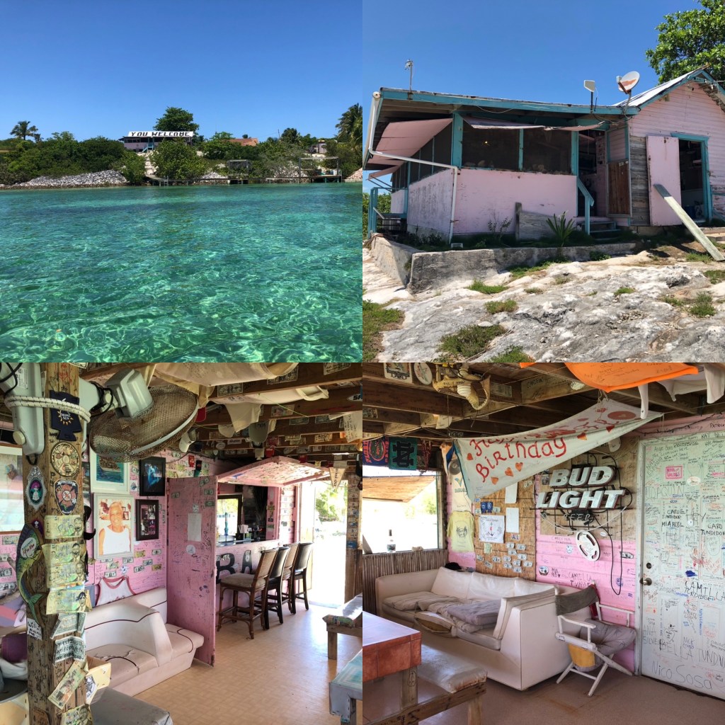
I’m writing in the past tense because that was all destroyed during an earthquake in January of 2020, and it hasn’t been repaired or replaced yet. The quake also caused some sinking of the land and the mangroves have filled in. The park is officially closed, so visiting is at one’s own risk and with one’s own means of transportation; the ferries don’t go there anymore. We dinghied over and landed on a couple of very tiny sandy spots to walk what remains of trails we could find. We dinghied partway through one of the mangrove creeks and saw lots of fish. Dave and I snorkeled part of the reef on the south side of the island. The first dive mooring we picked up was in a field of sea grass overgrowing tumbled, dead coral, but we had more luck on the other ball closer to the breaking part of the reef. The hard coral was mostly dead, but its structure remained. It must have been amazing when it was alive. There was new coral growth, which is encouraging. We saw a small, healthy elkhorn coral and some fire coral, as well as some other hard corals for which I don’t know the names. We saw the usual suspects of small fish. It wasn’t a great snorkel, but it is a pretty little island.
Gilligan’s Island
mangrove creek on Gilligan’s Island
Ocean playing fetch with Dave
Dinghy landing on one of the “beaches”
Barry & Andrea of s/v Caretta
remains of a fire pit
Gilligan’s Island ruins
remnants of the dock at Gilligan’s Island
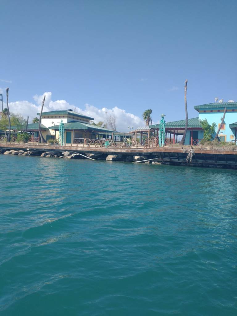
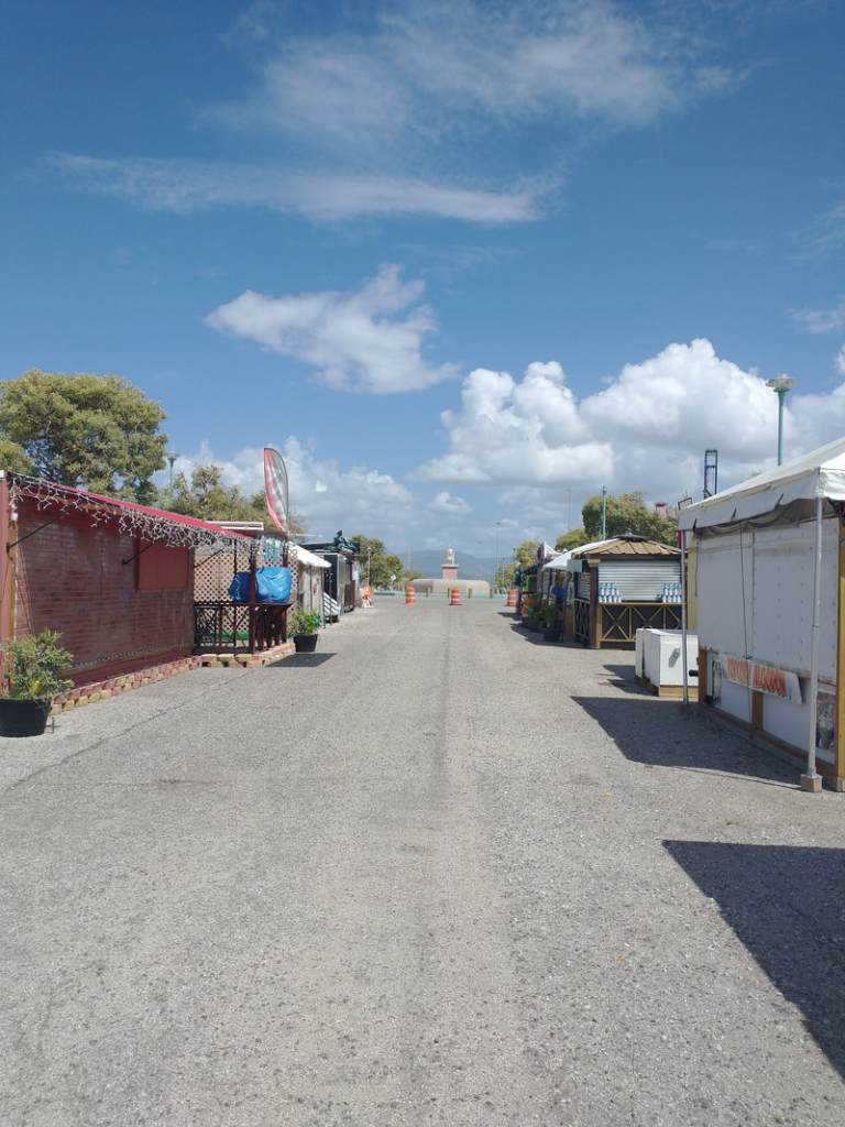
The next day was Tuesday, April 18th and we moved with our buddy boats the short distance east to Ponce. The preferred anchorage is near the Yacht Club. It’s a small area and not very pretty, not to mention crowded with the mooring balls and anchored boats. It’s the first time we put out our typical 5:1 scope to set the anchor, but then drew it in to a 3:1 scope. (Scope is the ratio of water depth to length of anchor line/chain put out. If the water is 10’ deep, we would put out 50’ of anchor chain for a 5:1 scope, 30’ for 3:1.) Sometime in the late 1990s, the La Guancha Boardwalk here was opened to the public. It was a hot spot on the weekends, especially at night. The waterfront was lined with shops, restaurants and bars. Again, past tense. It was heavily damaged by Hurricane Maria in 2017, and before any repairs were started it was damaged further by the January 2020 earthquake. There is a fishing cooperative at one corner of the anchorage that allows dinghies to tie up (the Yacht Club does not). So we went ashore and wandered a bit. About ¼ mile from the original boardwalk we encountered a park with food trucks lined up along the way. It’s a makeshift replacement for the boardwalk, but being a Sunday, the trucks were closed, except for a couple that sold drinks and hot dogs. We wanted a more substantial lunch and there was nothing within walking distance. One of our group had seen another dinghy dock at another fishing cooperative about a mile up into the bay. So we dinghied up and asked the fishermen and the DRNA officials (there was an office there) if we could leave our dinghies for a couple of hours while we got lunch. They put us all into an empty slip and recommended a restaurant about ½ mile down the road. It was a yummy lunch!
La Guancha ruins from the water
…and from land
Area where the temporary “La Guancha” is
Some of the food stalls
I had mofongo, and it was very tasty!
That was the sum total of our time in Ponce, at least for us and Caretta. Wild Horses stayed another two night and took care of some provisioning. Wednesday morning, we and Caretta headed 5.5 nm southeast to Isla Caja de Muertos, which is where I will pick this up next time. Until then, stay safe and take care of each other!
My post on Saturday ended with my birthday at the Fowl Cay anchorage across the cut from Rocky Dundas. I’ll pick up from there and get you to our last stop before we headed to George Town. This one is not quite as long as Saturday’s.
On February 1st we made the short jump south to Staniel Cay. We walked about the island shortly after our arrival and picked up some fresh produce at each of the two little markets there, and some rum at the laundromat/liquor store. The town is smaller than Great Harbor Cay, with only a little over 100 permanent residents. It’s a welcoming island that includes one marina, the Staniel Cay Yacht Club. Our primary reason for stopping here, however, was to snorkel Thunderball Grotto. This underwater cave was so named because it was used in the 1965 James Bond movie Thunderball, starring Sean Connery (which we watched the night before). It has also appeared in Never Say Never Again (another Bond movie) and in Splash with Tom Hanks and Daryl Hannah. We were anchored about a football field’s distance from the cave, so it was a short dinghy ride the next morning. We arrived about an hour before low tide and the water was low enough already that we didn’t have to swim underwater to clear the ledge, we just swam right in. We arrived there with only two other dinghies and entered the water faster than they did, which gave us 5+ minutes to ourselves, a rare treat at this popular tourist spot. Besides it movie fame, it was fun to be inside. This one was bigger than those at Rocky Dundas, and there were schools of sargent majors, jacks, grunts, etc. inside. People tend to feed the fish here, so it’s no wonder they all hang about and greet the snorkelers. We did not feed the fish. We gawked both above and below water, and poked around the underwater nooks and crannies until the cave got crowed with people. Then we swam out and explored the reef around the island to the other side. On the opposite side we found the always below water rear entrance to the cave. We didn’t brave that, though, because I don’t trust my ability to hold my breath long enough yet, or to stay far enough below water while holding my breath to not hit my head. By the time we got back to Lady there were about a dozen dinghies and a couple of high-powered tourist boats full of people there to explore the caves. Guess we got there at the right time.
After we returned from Thunderball Grotto, we had lunch then hauled anchor and moved a few miles south to Black Point on Great Guana Cay. This was a quick stopover, but we didn’t want to miss the world-famous Lorraine’s Café and the chance to meet Lorraine herself. Cruisers rave about Lorraine and all she does for the cruising community, plus she serves as a station host for the Seven Seas Cruising Association. We did get to have a quick chat with her on the deck of her newly opened restaurant called The High Tide, that has a lovely view of the harbor. We bought a loaf of regular coconut bread and a loaf of cinnamon coconut bread from her mother, whose house sits right between the new restaurant and the original (and yes, still open) Lorraine’s Café. We took a walk through the tiny town, then returned to The High Tide for conch fritters and rum punch before returning to Lady. That night as we were preparing dinner we got to watch a few small, local built boats practicing for the Little Farmers Cay Regatta that started the following day. Can those folks sail! It was impressive to watch, and we were glad for that brief opportunity, because we would miss the actuall regatta itself.
The next day we went ashore to have lunch at Lorraine’s Café and realized, too late, why most cruisers mention going for dinner rather than lunch. During the day, tour boats with 20-30 people apiece show up for a buffet at Lorraine’s. They come one after another starting around 11:30 am. We waited almost 90 minutes for our food to come out to the deck because of the hordes of people inside. Lesson learned. I very much enjoyed my conch burger, though. We still got back to Lady in time to haul anchor and head for the north anchorage at Little Farmers Cay. We didn’t have time to stay for the regatta, we just wanted to shave 10 miles off of our trek to George Town the following day. We spent a lovely evening at anchor there, listening to the distant regatta party music at the marina on the other side of the island.
The following morning, Saturday, February 4th, we got up before dawn, had our cups of coffee, and hauled anchor just before sunrise for George Town. That is where I will pick up with my next post.
Until then, stay safe and take care of each other!
Get cozy and grab a drink and a snack, because I’m covering a lot of water. I was going to take you all the way to George Town in this post, but that would have been way too long. Instead, I’m doing something I rarely do; I’m posting today and again on Wednesday to get you to George Town, which we will have already left by the time these two posts get you there. Still, it will keep you only about a week behind our actual location. Here we go…
In my last post we had just arrived at Warderick Wells, which is where the Exuma Cays Land & Sea Park headquarters are located. We had planned to stay only two nights, but we were boat bound our first full day there due to winds in the high 20s gusting to the low 30s with off and on rain all day, so we stayed one more night, which allowed us to walk ashore in a couple of places the next day, and also to snorkel Emerald Rock. The morning after the big winds, Dave and I hiked up the famous Boo Boo Hill and poked around for a bit. We did not contribute to the pile of boat names on drift wood at the peak because we are lame and forgot to make a sign <sigh>. Dave & I did some mediocre snorkeling at Emerald Rock after lunch. We’d had higher expectations of the snorkeling in the park, but conditions relegated us to just Emerald Rock. There were several very tiny patches of reef that together may have had a slightly larger footprint than Indigo Lady. There were a bunch of the usual suspects (fish) one expects on small, shallow reefs, but nothing as large as a barracuda, let alone a shark. I guess the really good snorkeling/diving was in the cuts between islands that we just couldn’t time correctly during our very short stay. After our dive, Dave, Mom and I dinghied down to Rendezvous Beach and took a short trial to poke around some very old, almost no longer existent plantation ruins before heading back to Lady for drinks and dinner. The snorkeling may not have met our expectations, but the views of and from Warderick Wells are amazing! It was a lovely setting.
I enjoy the sound of water lapping against the hull and the feel of the gentle rock of the boat as I fall asleep. Our last night on the Warderick Wells mooring ball was not that. It was dizzying and loud. While we were playing cards before bed, we watched the anchor lights in the mooring field whiz past us one way and then the other as we swung like we were on a Tilt-A-Whirl. Those who remember that amusement park ride know what I’m talking about; the rest of you can google a video of it. I hope you don’t get motion sick. As we retired to bed, the wind and current were opposing each other and we kept coming up tight *in front of* the mooring ball with it banging between our hulls, then the lines would relax, and then repeat coming up tight. The banging of the ball between the hulls plus the sound of our bridle lines tensioning repeatedly was enhanced in our echo-chamber cabin. It was very noisy until the tide changed and I could finally get to sleep.
We left Warderick Wells to anchor between Soldier and Little Halls Pond Cays so we could snorkel what is called the “sea aquarium.” We really wanted my folks to be able to do this, which meant taking Lady over there because they can’t get back into dinghy from the water. The dive moorings are designed for dinghies and tour boats smaller than Lady. So we picked up a mooring and got my folks in the water while Dave stayed at the helm to keep tension off the mooring line and keep us off the nearby rocks. I kept watch on the mooring and my folks. The wind and current were opposing each other, which is tetchy enough, but suddenly one of them overpowered the other and our bow started being pushed toward the very nearby rocks. I struggled to drop the mooring ball from our stern and shouted to my folks to stay put. Thank goodness Dave has the lifetime of boating experience he does, because he managed to maneuver us such that only the last part of the starboard sugar scoop scraped a small point of rock. It left us with a 4-6” gash in the fiberglass outer layer of the cored hull, substantially above water line. It has been temporarily patched with flex seal and is awaiting a proper repair of glassing and gel coat which we’ll probably do when we have her hauled at the end of the season. We circled around and picked up my folks who had thoroughly enjoyed seeing all the fish and coral on their brief dip. We returned to our anchor spot and then Dave and I dinghied over for our turn snorkeling the “sea aquarium.” It really is a lovely spot with tons of fish and healthy coral. We got cold pretty quickly, though, so it was a pretty brief snorkel. We surmised later that we probably got chilled so quickly because we were both coming down from the adrenaline rush of saving Indigo Lady from total destruction!
On to something more pleasant…
We spent my birthday anchored at Fowl Cay, on the south side of Conch Cut, which is the southern boundary of the Land & Sea Park. The southernmost island in the park is called Rocky Dundas with caves one can snorkel into under the ledge at low tide, which we did at the low tide on the morning of my birthday. There were three other dinghies there, and the caves aren’t very big, so we enjoyed the coral and fish outside the entrances as we waited our turn. The caves were really cool! You just swim in, get your feet under you, stand up and gawk for a few minutes at the stalactites and stalagamites. There were two caves. The more southerly one we could actually get up onto a dry (at low tide) rock shelf to stand and look around stably. The northerly cave had more surge so we stood but struggled to keep our feet. It was pretty spectacular.
After lunch all four of us dinghied to the small reef about a football field’s distance from Lady at the northwest corner of the anchorage. It was a pretty little reef with quite a bit of healthy coral and a bunch of fish, and it was out of the current. I even saw a small nurse shark and a large barracuda. We have a ladder we attach to dinghy’s stern to aid our getting back into dinghy from the water. We weren’t sure my folks would be able to use it, since there is very little room between it and the motor, and one still needs to stay balanced on the ladder while using one’s upper body to gently pull oneself over the transom. So we came prepared to tow them back to Lady with lines and a couple of floaties we keep onboard. Mom actually managed the ladder, but it was too tight a space for Dad, so we towed him back, which he enjoyed. Back aboard Lady, we enjoyed fruity rum drinks, a pasta dinner, courtesy of Mom, followed by cards and a chocolate banana bread I had made earlier. It was a great birthday!
The slide show below starts with Shroud Cay, which I mentioned briefly in my January 28th post, but since it’s part of the Exuma Cays Land & Sea Park, the pictures ended up here. The picture at the top of the post is a reef shark that greeted us when we arrived at Warderick Wells.
The next installment of our route to George Town will post this coming Wedenesday the 22nd.
Until then, enjoy the show below, stay safe and take care of each other!
We left the Glass Window anchorage on May 3rd and retraced our steps through Current Cut back to the Spanish Wells area where we would stay through May 12th. We returned to this area for several reasons. First of all, Peter, whom we’d met just before my folks left, was returning to the area with some friends and we wanted to spend some time with them snorkeling the reefs near Gun Point because, and this is reason #2, the seas were going to be calm enough to snorkel these Atlantic-side reefs. The third reason was that we had ordered a part for our failed starboard generator and were waiting for it to arrive.
Our first night back in the area we anchored off a small island called Meek’s Patch, located between St. George’s Cay (Spanish Wells is the town on that island) and North Eleuthera. Peter and crew arrived just after us and we spent the afternoon and evening onboard getting to know his friends Michael, Nila and Wendy. We had a great time and they fed us freshly caught mahi! Who knows how long we would have stayed chatting if the thunderstorm hadn’t threatened and sent us scurrying back to our boat. It ultimately amounted to only a sprinkle.
Over the following five days we did some snorkeling together, took Nila to Preacher’s Cave with us, and shared dinner with First Edition four more times. It was usually them providing us with freshly caught fish from that day’s spearfishing. We contributed potato salad once. On our final night together, I made a chicken stew in our slow cooker and we brought it to their boat. After dinner we got to spend a mosquito-free night hanging out in the bow on Peter’s big boat bean bags, chatting the hours away. As always, it was a bittersweet farewell with the promise of seeing each other next season. We know we’ll connect with Peter at least, because he’s usually stationed in Georgetown and we will be heading there next season. Dave & I were up the morning they started their trek back to Georgetown, so we got to bid them fair winds and following seas with air hugs one more time.
I mentioned Preacher’s Cave. The reef on the north side of North Eleuthera that wraps around toward Harbor Island to the east is called Devil’s Backbone. Many ships have wrecked there. In 1684, a group of British from Bermuda set out seeking religious freedom in the Bahamas. Their ship wrecked on the reef. Everyone survived and they slogged their way ashore and found refuge for many months in this cave and the surrounding area. One of their members salvaged their boat (or maybe it was their equivalent of a tender) and sailed to the Carolinas area of the US, got provisions and made it back safely to the Cave. These folks eventually created a settlement in the area. I find cruising challenging enough in this modern era; I can’t imagine leaving one’s home for foreign, unsettled areas like they did!
When we weren’t hanging out with the First Edition crew, Dave and I did some solo snorkeling, renewed our cruising permit at the Spanish Wells Customs office, got one of our propane tanks refilled, got some groceries and more liquor, used the WiFi at Wrecker’s (restaurant at Yacht Haven Marina) for Dave’s STEM Guitar meeting when the cell service went down on the island one afternoon, listened to a couple of Bruin’s playoff games, and I rested my back. I did a little too much snorkeling and my back was horrible for about 3 days (had to resort to taking Flexeril). Once First Edition left, we moved to an anchorage on the south side of Russell Island just outside the entrance to the Spanish Wells harbor (about a ½ mile dingy ride into the public dock). We were there for four days1h5 v doing boat chores, running errands ashore when necessary, had a lot of hammock time, ran into some friends we met in Bimini last season, and were constantly checking on the status of our generator part. It finally arrived the afternoon of the 12th! We picked it up, ran some final errands, returned to Lady and hauled anchor around 3:30 to head back to the anchorage above Current Cut. Anchored by 5:30pm and Dave installed the new part. It did not solve the problem. Damn! A whole bag of Doritoes and a movie in the hammocks as consolation. The next morning, Friday the 13th, we headed to Hatchet Bay.
That wraps up Spanish Wells, and since I’ve already written about Hatchet Bay, my next post will probably pick up with the stop after that, which was Alabaster Bay, unless something else comes to mind. Until then, stay safe and take care of each other.
I’m bombarding you with posts this season! I’ve been in the mood and have had the time. It’s a good use of passage-making time. Most of our passages have been 2-3 hours with an occasional longer one. Today we are cruising from South Palmetto Point to Rock Sound Harbor, about 23 nm and 6 hours. It’s a good time to get ahead.
I’m going to back up to late April/early May when we were still in the Spanish Wells area. If you’ve been following us this season, you know my folks left on April 26th to return home. After we saw them off, we dropped the dock lines at Yacht Haven Marina and cruised to the Atlantic side of Egg Island to do some snorkeling because the seas were actually calm on the ‘outside.’ We snorkeled a couple of times on our own. After our second day of snorkeling we stopped by a new catamaran in the anchorage, SV Breathe, and chatted with Jason & Monica for a bit, arranging to join them for appetizers and sundowners on their boat later in the day. We did do that, and had a great time with them and their buddy boat friends, Cindy & Ron on @SV Reef’n It!
The next day we all snorkeled together. There was a bit more swell and lower visibility, but we still saw some great stuff. Jason takes amazing underwater photos; check out his web page or Facebook page @BreatheSailDive. That evening we had them all over to Indigo Lady for appetizers and drinks and a tour of our boat. They were also able to give us some intel about things to see and do on our way along Eleuthera, which has paid off in spades. We exchanged social media contacts so we could stay in touch, and they headed back to their boats a little after 8pm. Cruisers lament- meet cool people and then have to part ways (I’m sure I’ve said that before). They were heading off for the Abacos the following morning. Sigh. Hopefully our paths will cross next season.
On the last day of April, we moved to anchor off Current Settlement on the southern end of North Eleuthera. This put us in position to pass through Current Cut, between North Eleuthera and Current Island, with the proper tide because it can have a wicked current a boat like ours doesn’t want to go against. We walked through the tiny settlement to sit outside their library, closed that day, to use their WiFi. We were still having data issues at the time, so we took any chance at free WiFi we could get.
Passing through the cut the next morning was smooth, but the cruise to the Glass Window anchorage was a bit bumpy; not horrible, just not comfortable. It was a nice, calm anchorage though and we arrived in time for lunch followed by a walk ashore. We landed the dingy on the beach and followed a short trail to Queens Hwy to find we were directly across from one of the natural wonders we wanted to see- Queen’s Bath. This is a large area of basically very large tide pools carved out of the limestone from years of bashing by the sea. One can only go down into the baths at low tide and as long as the waves aren’t still crashing and spraying. We got the low tide, but the sea was quite active and we didn’t have the best footwear to climb down anyway, so we appreciated the beauty and awesome power of nature from the top.
We next walked a little further north to Glass Window Bridge. This is a very narrow isthmus just north of Gregory Town and east of Lower Bogue where you can see simultaneously the Atlantic on one side and the Bight of Eleuthera on the other. The Atlantic side sports 80-foot cliffs. In the 1800s it was topped by a rocky ledge (Winslow Homer painted this), which has long since been destroyed by hurricanes. The succession of manmade bridges haven’t fared much better over time. There is no reef to break the waves from the Atlantic side, so storms at sea often create waves that funnel themselves into the narrow Atlantic-side cliffs throwing up waves that wash over the bridge to the Bight of Eleuthera on the other side. Over the years they have occasionally taken an unsuspecting car and/or person over with them (here’s one such story). We were fortunate to see it on a calm day, so we could safely walk across it to take pictures from both sides. My pictures don’t do it justice.
After Glass Window we started our walk back to dingy but decided to go a little past it to see if we could find the restaurant/bar rumored to be nearby. Half a mile later we were sitting at Daddy Joe’s enjoying conch fritters and mac ‘n cheese sticks, along with a drink called a Kerpunkle, which we learned is Bahamian slang for shit-faced. Aptly named, because the drink was strong with rum. Yum! Our ‘snack’ was large and late in the afternoon, so dinner on board was cheese and crackers and fruit.
We’d planned to go back to Queen’s Bath the next day, but dingy needed a patch repair and we wanted to give it a solid 24 hours to set before using it again. So we stayed aboard all day. I made English muffins and did three loads of laundry while Dave patched dingy and did some other stuff. We lazed away the afternoon in the hammocks. The following day, May 3, we moved back through Current Cut to the Spanish Wells side. More about that in my next post. For now, enjoy this video slideshow of the sights described here, stay safe and take care of each other.
Grab a beverage and find a comfy seat; this is a long one.
The Berry Islands are a small chain of islands about 57 nm (nautical miles) SE of Freeport on Grand Bahama and about 72 nm east of Bimini (or about 115 nm east of Miami). The island chain is bordered by the Northwest Providence Channel, the Northeast Providence Channel, and the vast, shallow Grand Bahama Bank. The northernmost islands are Little and Great Stirrup Cays, owned by Royal Carribbean and Norwegian cruise lines, respectively. Royal has dubbed Little Stirrup as “Perfect Day at Coco Cay.” Cocoa Cay is full of beaches, beach bars, water slides, and even a hot air balloon. Great Stirrup is set up as more of an adventure island with ziplines and such. This is from what we’ve read and seen as we’ve cruised by them (7 times thus far). The only town in the chain is on Great Harbor Cay, just south of the Stirrups, population around 400. The Stirrup Cays provide employment for a very large portion of the town. One local we spoke with estimated about 75-80% of adults are employed by those cruise lines in some way. Currently, the cruise lines do not offer excursions to Great Harbor Cay. In town there are two small grocery stores, several restaurants, a marina (one of the best hurricane holes in the Bahamas), several rental properties/inns, an air strip, a bunch of privately owned houses outside of town (owned by foreigners), and lots of friendly people. At the southernmost end of the island chain is Chub Cay, which is a big sport fishing spot that gets a lot of traffic from high speed powerboats from Florida, plus they also provide sport fishing charters for those who fly in. The inbetween islands are either uninhabited or privately owned. I’ll let you look at a map and try to count the number of islands that make up the Berries; I stopped counting at 45. The Berries are not a tourist hot spot, except for Chub Cay, but they do have their regular visitors by land and sea who appreciate them for their quiet, remote anchorages and friendly town.
From Explorer Chartbook: Near Bahamas
If you’ve been following my blog for a while, you may recall that Dave and I were here with my folks, on Indigo Lady, back near the start of the pandemic in late March/early April of 2020. There are worse places to be stuck for two weeks during uncertain times, but I’m glad we’ve had the opportunity to return and enjoy them differently this year. Yes, the pandemic still rages on, but the Bahamas figured out a way to reopen their borders to the much-needed tourists. Just like at home in the U.S., we follow whatever mandates each island group has in place at the time.
You don’t come here for the abundant daytime activities and the night life. This is a place where you meet and talk with the locals and get to understand their way of life. When we were here in late May this year, we biked the southern half of the island, walked about town, and met Ronny and Gaynell who own and run Brown’s Garden restaurant. We returned here from the Abacos in mid July and spent a few days anchored off town again. We returned to Ronny’s & Gaynell’s restaurant. The day we lunched there, Ronny invited us to come back for a cookout that evening that was a sendoff for his wife. She was promoted and would be spending a couple of years mainly living and working in Nassau, visiting with Ronny on weekends as one or the other of them would fly over to the other island. What a sacrifice! But they have plans and are working towards them. It was very sweet of Ronny to invite us and Gaynell introduced us to his family. This is the kind of experience one has on an island like this. Had we been here earlier in the cruising season, we would have availed ourselves of the socializing that goes on in Great Harbor Cay Marina. We heard that they do a group cookout on Fridays and pizza takeout on Saturdays. Alas, the marina was mostly empty when we returned in July; only a few boats stopping for a night or two.
We left Bullocks Harbor the morning of July 21st and started our trek down the eastern side of the island chain to spend some time at those quiet, secluded anchorages. We weren’t in a rush, so we took three days to get to Little Harbor Cay, the furthest south we planned to go. My post from July 24th takes you from Bullocks Harbor through our running aground and to the anchorage behind Little Gaulding. We spent two nights at that anchorage, which we did not enjoy because of the current and opposing swell. The morning of the third day we caught the rising tide down to the northwest end of Little Harbor Cay where we anchored on the west side of the island just below the NW point. It was another sandy-bottom, clear water anchorage and well protected, so it was blissfully calm. There was only one (very large) boat moored bow and stern. We stopped by briefly to say hello as they were heading off in their tender one morning. Turns out the owner of the boat also owns Big Gaulding Cay and they were heading over for a cookout. He graciously invited us to come over, but we weren’t in the mood for a hot day ashore so we declined. We spent three nights anchored here.
While at this anchorage, we found the little trail across to the Atlantic side and walked the beach. We dinghied over to the west side of nearby Comfort Cay to explore the underwater blue holes someone had told us about. Dave explored the blue holes snorkeling. We weren’t sure about the holding for dinghy’s anchor, so I stayed aboard just in case. I wasn’t terribly interested in this blue hole anyway. When Dave finished, he said he was glad he checked them out, but wasn’t interested in trying to move Lady over there to dive them with the hookah. He’s done his share of deepwater diving and is more interested in the reefs these days. After the blue holes, we decided to act upon the real reason we chose to go to Little Harbor Cay- the opportunity to eat at Flo’s Conch Bar. The restaurant was established in 1993 by Chester Darville, who returned to the island of his upbringing after almost 20 years. His mother, Flo, was the head chef until her passing in 2011. The family and workers are the only inhabitants on this island and they occupy a couple of buildings next to the restaurant. Other than a “camp” on the north end of the island, there are no other signs of civilization. Flo’s is not always open, so one has to make a reservation in advance. Unable to reach the restaurant by email, phone, or VHF, we stopped by after our blue hole excursion to arrange to have lunch there the following day. The restaurant is renowned for its Bahamian dishes and they did not disappoint! We did in fact have lunch there the following day, having arranged to have “a little of everything.” We enjoyed conch fritters, lightly battered and fried fish fingers, coleslaw, and Bahamian peas and rice, accompanied by a rum punch. Delicious! We also got to enjoy conversation with a lovely family who was also lunching there. The son/grandson (about 9-10 years old) regaled us with his knowledge of all things science. He was a joy! Lunch was so huge that we ended up bringing leftovers back to Lady that served as lunch the next day. “Dinner” later that night was cheese, crackers and pepperoni, quite late because we were still full from lunch Flo’s was certainly worth the trip!
Flo’s Conch Bar
The following day we caught the afternoon rising tide back to Hoffmans Cay where we anchored and stayed for 10 days. Hoffmans is uninhabited and the epitome of a quiet, remote anchorage. The only other boats we saw were a half mile or more away and anchored either off Little Gaulding or White Cay. A bit different than last year when we shared the anchorage with several boats also waiting to see what the pandemic would bring for cruisers. It is also much hotter here in July and August than it was in late March/early April. The temperature might get as low as 84-85oF overnight and as high as 89oF during the day (only saw 90oF once). There was a period of several days with very little breeze, making it feel even hotter. The days kind of run together at this point. Most days we did at least one thing off boat, but we spent a couple of really hot, nearly windless days onboard in the shade of our solar panel roof, in the hammocks, dipping into the water to cool off as necessary. Most afternoons were spent in the hammocks, followed by dinner and then either games, a movie, or the Red Sox. We also tended to basic chores and some projects.
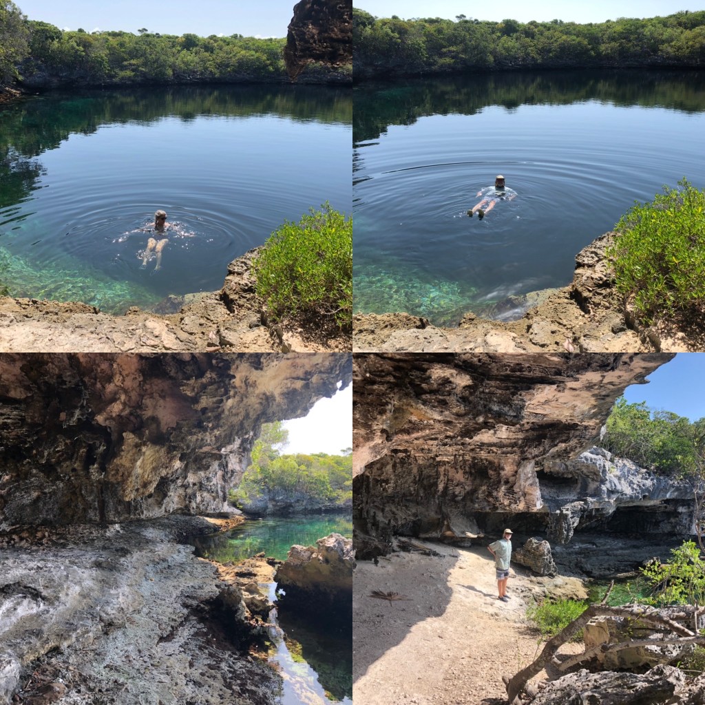
Over the course of our stay at Hoffmans we walked to and took a dip in the blue hole on the south end of the island. This blue hole is on land and is fed by the ocean from an opening on its bottom. Someone we met said it’s around 55’ deep. We walked the Atlantic side beach twice, the second time visiting the stranded power boat we saw last year. It has moved! We dinghied into a little bay full of sea turtles and up into the mangrove river on the rising tide. Last year we saw a bunch of fish among the mangrove roots, but this time we saw only a small school of needlefish and a couple of other small fish. Last year we’d seen a school of bonefish in the bay, so this time Dave set up to cast for them but, alas, there weren’t any. We snorkeled the ledges around two small beaches in sight of our anchorage. We didn’t see as much big life this time, although we did see a couple of trigger fish and a 5-6’ shark, which we thankfully only caught a glimpse of before it swam off. It wasn’t close enough long enough for us to identify it properly, but it was probably a reef shark. We walked the long, northernmost beach (also anchorage side) a couple of times. It’s only a “long,” one-mile beach at low tide. You can wade out into the water quite a way in a couple of spots and be standing on exposed sand. At the far end there is a remnant spit of coral that sort of forms a little bay where we saw a baby shark, very whitish and only about 2’ long, likely a juvenile and no idea what species. These walks also revealed one good sized ray, one barracuda, and several trigger fish, all right up in the shallows, plus a bunch of yellowfin mojarras (had to look those up) and little crabs that would scurry away from our feet and burrow into the sand. Along the shore there were many curly-tailed lizards, laughing gulls, plus we saw some sort of heron and an osprey. Our last day at Hoffmans we decided to snorkel off the long beach to see the sealife from in the water. Of course none of the big stuff graced us with their presence that day, but it was a fun and cooling way to spend a hot couple of hours.
Before we knew it, it was time to head back to Great Harbor Cay. As I write, we are two thirds of the way back. We spent Thursday night anchored off Soldier Cay again. This time we snorkeled to the beach and around the southern point and took a brief walk ashore. Last night and tonight we are anchored in Great Harbor behind the Stirrup Cays. Tomorrow we return to Bullocks Harbor. Monday we will go to Immigration to renew our expiring visas; we’ve spoken to the immigration officer, who is expecting us. Then we start the process of closing up and securing Indigo Lady for the next 5 months or so. We’ll do some of the closeup prep at anchor in Bullocks Harbor where we can benefit from the breeze, but the final couple of days we’ll need to be on a slip in the marina. We booked a room at the nearby inn for those final two nights.
I’m not sure if I’ll have the time or energy to post next weekend. Maybe I’ll knock off something when we’re back in the U.S. and at the hotel next Saturday night. Dave is having an interesting day today, with a couple of troubleshooting/repair jobs, one of which I wouldn’t wish on anybody. You’ll have to wait until next post to find out what that is.
Until then, stay safe and take care of each other!