
Happy July!
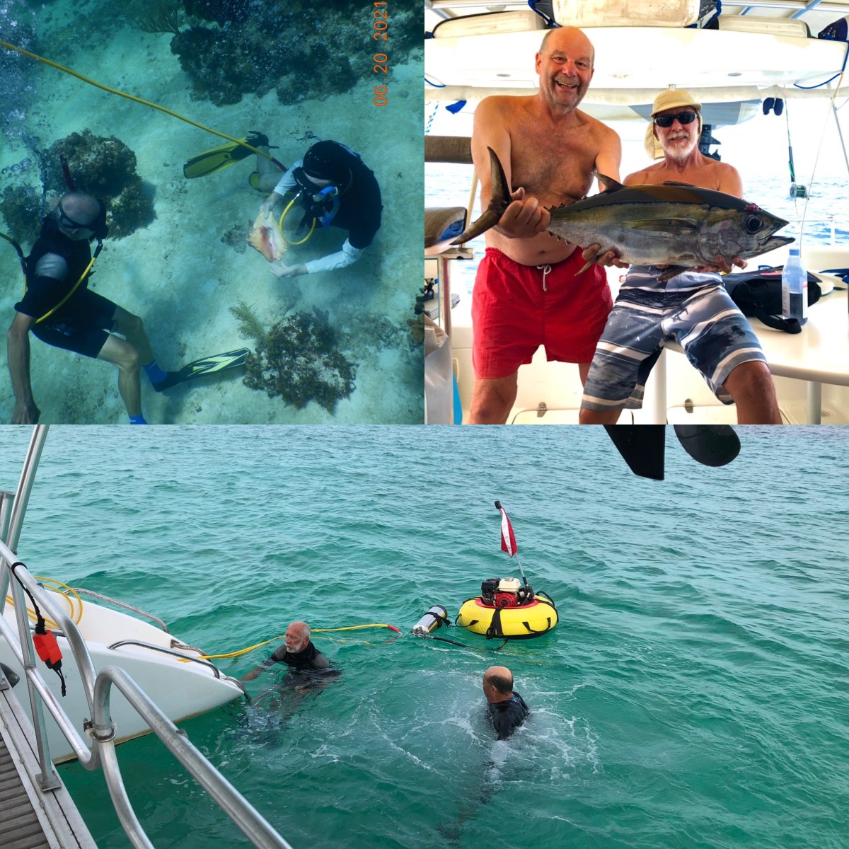
We continue to enjoy our time here in the Abacos. Our friend, Ian, was with us for a little over a week. We did a bunch of diving and eating lunches ashore, enjoyed quiet anchorages, we even caught a tuna (and by “we” I mean Ian and Dave). It was wonderful to share an extended period of time with another human after more than a year of social distancing. (Thanks for coming, Ian!) He flew home this past Sunday. Dave and I did some boat chores, rested up a bit, then started planning our remaining time here in the Abacos. There is one more island we want to explore, Manjack Cay (also called Nunjack, locally), about 5-6 miles NW of Green Turtle Cay. We’re en route there now, but the timing of our arrival will depend on the path and timing of Tropical Storm Elsa. As with every day cruising, Mother Nature will decide.
It may seem a bit early, but even as we head for Manjack Cay, we’re already thinking about how we will return to the Berry Islands for August. Again, we work on Mother Nature’s schedule and that is ever changing. We can’t afford to miss a good weather window. At this point we’re just exploring route options. My goals are to pick a route that (a) l is ikely to provide the most comfortable ride, (b) minimizes the number of days we just “make miles,” and (c) isn’t boring. We are weighing the pros and cons of each route. If we are incredibly lucky, we’ll be able to accommodate both goals, but I’m not holding my breath. There are a couple of options north from Manjack, or we can return the way we came via the south route around Hole in the Wall. From Manjack, the route distances are similar.
Going back the way we came means going back down to the area of Little Harbor and possibly waiting there for the right weather window to make the trip around Hole in the Wall. It would be a comfortable place to wait. This route would require us retracing our path through the Sea of Abaco. This isn’t a bad thing, because this is where we’ve been hanging out for the past 5 weeks and we like it here. We could transit the area quickly or take our time and revisit some of our favorite spots one last time. We know the anchorages and harbors we can avail ourselves of on this route. This route is not remote, well, compared to the north routes. The route from Cross Harbor across the Northwest Providence Channel to the Berries is a good angle for the prevailing seas and winds this time of year, plus we have our track line to follow and know we can anchor in the dark at GHC, so timing isn’t an issue on that leg of the journey. A potential disadvantage is finding a good weather window for the first leg around Hole in the Wall. We’ll be traveling SSW from Little Harbor and then NW a short distance up to Cross Harbor. This time of year, the prevailing winds and seas are E-SE. Winds under 10 knots and seas under 4 feet with a long period from SSE would be ideal. The more south or the more east, the bumpier the ride gets, unless the wind and seas are so light as to not matter. If we choose this route, we’re committed, because the other routes are too far north from Little Harbor for us to change our minds.
Alternately, we could continue northwest from Manjack Cay and then west across the top of Little Abaco and West End Cay, down into the Bight of Abaco to Mores Island, then from Mores Island cross the Northwest Providence Channel to Great Harbor Cay. This is a more remote route with many small, uninhabited islands. Remote and quiet can be very nice, when the conditions are good. This is also an exposed area with fewer anchoring options if winds shift in different directions. How much we would get to enjoy these quiet areas would depend on the weather. If we get a stretch of calm, we could dub our way to the Bight, otherwise we’ll find ourselves just making miles so we can get to the next protected area. A big advantage to this route is that the prevailing wind and sea directions this time of year would be in our favor, and the Bight tends to be calm unless winds are over 15 kts. One of the challenges of this route is the need to time our entry into the Bight with the tide at Spence Rock before continuing another 38 miles to Morse Island, with no option to stop in between. If mid tide rising isn’t early enough we’ll be trying to anchor at Mores Island in the dark. We’ve also heard that the Bight of Abaco is a thunderstorm magnet this time of year. Mores Island sounds like a reasonable place to wait for a weather window to cross to Great Harbor Cay, should that be necessary, and the route from Mores island to GHC is pretty good for the prevailing winds and seas.
If we didn’t want to take the south route and didn’t want to risk the shallow Bight of Abaco and its potential thunderstorms, we could continue about 50 miles past Little Abaco and then turn south to enter the north end of the Grand Lucayan Waterway, a canal system that bisects Grand Bahama Island. Again, prevailing winds and seas are likely to be helpful, which is an advantage. We’d have to time our entrance across the shallow north entrance of the canal with the tide again, but once inside the canal system there are numerous offshoots in which we can safely anchor if we can’t transit the entire canal the same day. The angle from the south end of the canal system to Great Harbor Cay is less likely to provide a comfortable ride given the prevailing winds and seas. It would seem less likely we would choose this route.
So there you have it, more information than you need about routes you probably don’t care much about. Dave and I keep wavering about which to choose. When we’re driving a car we will often return from a destination via a route different than that which we took to get there. Why go back the way we came when we can explore something else? It would be nice to check out the northern reaches of the Abacos, if the conditions were right. Alas, there’s no guarantee of the “right conditions” on the water, especially in a slow boat during hurricane season. Our decision point is Manjack Cay. When we’re done exploring there, we will have to commit to a route. Stay tuned!

Spanish Cay would be a good place to ride out the storm.
LikeLiked by 2 people
We’re in White Sound at Green Turtle. Good hurricane hole, and anchoring is free. 😁
LikeLiked by 1 person
I continue to read your posts in earnest. You capture my imagination with your descriptions and only wish it possible to provide a pencil map to compliment the nature of your journey. When you say 4 foot seas I think “Holy Cow”. Not a comfortable ride over a long period of time at least based on my experience. Stay safe and God be with you.
LikeLiked by 1 person